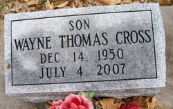
Wayne Thomas Cross
| Birth | : | 14 Dec 1950 Burlington, Des Moines County, Iowa, USA |
| Death | : | 4 Jul 2007 Mount Pleasant, Henry County, Iowa, USA |
| Burial | : | Belgrave Cemetery, Belgrave, Leicester Unitary Authority, England |
| Coordinate | : | 52.6653570, -1.1311220 |
| Description | : | The Burlington Hawkeye Wayne Cross Wayne Cross, 56, of Mount Pleasant, formerly of Middletown, died Wednesday, July 4, 2007, in the emergency room of the Henry County Health Center in Mount Pleasant. Wayne T. Cross, 56, of Mount Pleasant, formerly of Middletown, died Wednesday, July 4, 2007, at Henry County Health Center. Born Dec. 14, 1950, in Burlington, he was the son of Norbert and Ruby Fry Cross. He married Donna Whited. They divorced. On April 28, 1978, he married Diane Ray. She preceded him in death on June 17, 1999. On Jan. 12, 2001, he married Nancy Landes. Mr. Cross was a computer... Read More |
frequently asked questions (FAQ):
-
Where is Wayne Thomas Cross's memorial?
Wayne Thomas Cross's memorial is located at: Belgrave Cemetery, Belgrave, Leicester Unitary Authority, England.
-
When did Wayne Thomas Cross death?
Wayne Thomas Cross death on 4 Jul 2007 in Mount Pleasant, Henry County, Iowa, USA
-
Where are the coordinates of the Wayne Thomas Cross's memorial?
Latitude: 52.6653570
Longitude: -1.1311220
Family Members:
Parent
Spouse
Siblings
Flowers:
Nearby Cemetories:
1. Belgrave Cemetery
Belgrave, Leicester Unitary Authority, England
Coordinate: 52.6653570, -1.1311220
2. St. Peter's Churchyard
Belgrave, Leicester Unitary Authority, England
Coordinate: 52.6594208, -1.1255690
3. St James the Great Churchyard
Birstall, Charnwood Borough, England
Coordinate: 52.6741150, -1.1189210
4. Greengate Lane Cemetery
Birstall, Charnwood Borough, England
Coordinate: 52.6800110, -1.1346940
5. Leicester Abbey
Leicester, Leicester Unitary Authority, England
Coordinate: 52.6489600, -1.1369470
6. Thurmaston Parish Church Leicestershire
Leicester Unitary Authority, England
Coordinate: 52.6785900, -1.0993062
7. St Michael and All Angels Churchyard
Thurmaston, Charnwood Borough, England
Coordinate: 52.6785630, -1.0989530
8. St Margaret Churchyard
Leicester, Leicester Unitary Authority, England
Coordinate: 52.6403430, -1.1363440
9. Thurmaston Cemetery
Thurmaston, Charnwood Borough, England
Coordinate: 52.6788150, -1.0948670
10. Our Lady and St. Nicholas Churchyard
Wanlip, Charnwood Borough, England
Coordinate: 52.6910000, -1.1150000
11. Great Meeting Unitarian Chapel
Leicester, Leicester Unitary Authority, England
Coordinate: 52.6379400, -1.1360390
12. All Saints Church
Leicester, Leicester Unitary Authority, England
Coordinate: 52.6381940, -1.1403170
13. Gilroes Cemetery and Crematorium
Leicester, Leicester Unitary Authority, England
Coordinate: 52.6514359, -1.1721700
14. St. Nicholas Church
Leicester, Leicester Unitary Authority, England
Coordinate: 52.6351400, -1.1408940
15. Leicester Cathedral
Leicester, Leicester Unitary Authority, England
Coordinate: 52.6347430, -1.1370210
16. St George's Church
Leicester, Leicester Unitary Authority, England
Coordinate: 52.6344300, -1.1267420
17. All Saints Churchyard
Thurcaston, Charnwood Borough, England
Coordinate: 52.6906870, -1.1647320
18. St. Mary de Castro Churchyard
Leicester, Leicester Unitary Authority, England
Coordinate: 52.6322610, -1.1404000
19. Church of the Annunciation of St. Mary
Leicester, Leicester Unitary Authority, England
Coordinate: 52.6308229, -1.1417201
20. St Mary's Church
Anstey, Charnwood Borough, England
Coordinate: 52.6720090, -1.1888250
21. St Peter's Church (Defunct)
Leicester, Leicester Unitary Authority, England
Coordinate: 52.6300260, -1.1164980
22. St. Mary's Churchyard
Humberstone, Leicester Unitary Authority, England
Coordinate: 52.6479200, -1.0760100
23. Anstey Cemetery
Anstey, Charnwood Borough, England
Coordinate: 52.6680480, -1.1955570
24. Chapel of the Knights Templar
Rothley, Charnwood Borough, England
Coordinate: 52.7056000, -1.1478000


