
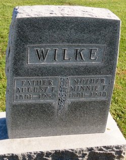
Wilhelmine Fredericke “Minnie” Lahrs Wilke
| Birth | : | 21 Dec 1881 Read Township, Clayton County, Iowa, USA |
| Death | : | 9 May 1938 Read Township, Clayton County, Iowa, USA |
| Burial | : | Liberty Cemetery, Petaluma, Sonoma County, USA |
| Coordinate | : | 38.2781990, -122.7055500 |
frequently asked questions (FAQ):
-
Where is Wilhelmine Fredericke “Minnie” Lahrs Wilke's memorial?
Wilhelmine Fredericke “Minnie” Lahrs Wilke's memorial is located at: Liberty Cemetery, Petaluma, Sonoma County, USA.
-
When did Wilhelmine Fredericke “Minnie” Lahrs Wilke death?
Wilhelmine Fredericke “Minnie” Lahrs Wilke death on 9 May 1938 in Read Township, Clayton County, Iowa, USA
-
Where are the coordinates of the Wilhelmine Fredericke “Minnie” Lahrs Wilke's memorial?
Latitude: 38.2781990
Longitude: -122.7055500
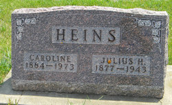
Family Members:
Parent

Spouse

Siblings
Flowers:


Nearby Cemetories:
1. Liberty Cemetery
Petaluma, Sonoma County, USA
Coordinate: 38.2781990, -122.7055500
2. My Pets Cemetery
Petaluma, Sonoma County, USA
Coordinate: 38.2472000, -122.6506000
3. Cypress Hill Memorial Park
Petaluma, Sonoma County, USA
Coordinate: 38.2472000, -122.6505966
4. B'nai Israel Cemetery
Petaluma, Sonoma County, USA
Coordinate: 38.2454700, -122.6490000
5. Calvary Catholic Cemetery
Petaluma, Sonoma County, USA
Coordinate: 38.2449000, -122.6493400
6. Oak Hill Cemetery
Petaluma, Sonoma County, USA
Coordinate: 38.2365130, -122.6509010
7. Two Rock Presbyterian Church Cemetery
Two Rock, Sonoma County, USA
Coordinate: 38.2570000, -122.7795029
8. Macedonia Methodist Episcopal Church Cemetery
Sebastopol, Sonoma County, USA
Coordinate: 38.3594860, -122.7727270
9. General Vallejo Ranch Cemetery
Sonoma, Sonoma County, USA
Coordinate: 38.2554500, -122.5845200
10. Canfield Cemetery
Sebastopol, Sonoma County, USA
Coordinate: 38.3512430, -122.8147040
11. Bloomfield Cemetery
Bloomfield, Sonoma County, USA
Coordinate: 38.3135986, -122.8583984
12. Chapel of the Chimes Cemetery and Mausoleum
Santa Rosa, Sonoma County, USA
Coordinate: 38.4141998, -122.7137985
13. Thompson Family Cemetery
Glen Ellen, Sonoma County, USA
Coordinate: 38.3644240, -122.5621210
14. Bennett Valley Cemetery
Santa Rosa, Sonoma County, USA
Coordinate: 38.4161987, -122.6619034
15. Sonoma State Home Cemetery
Eldridge, Sonoma County, USA
Coordinate: 38.3412190, -122.5427810
16. Pleasant Hills Memorial Park and Mortuary
Sebastopol, Sonoma County, USA
Coordinate: 38.3792000, -122.8350983
17. Jack London State Historic Park Cemetery
Glen Ellen, Sonoma County, USA
Coordinate: 38.3538000, -122.5367000
18. Calvary Catholic Cemetery
Santa Rosa, Sonoma County, USA
Coordinate: 38.4314003, -122.6847000
19. Luther Burbank Memorial Home and Gardens Cemetery
Santa Rosa, Sonoma County, USA
Coordinate: 38.4355810, -122.7118050
20. Sebastopol Memorial Lawn Cemetery
Sebastopol, Sonoma County, USA
Coordinate: 38.3981018, -122.8366013
21. Tomales Presbyterian Cemetery
Tomales, Marin County, USA
Coordinate: 38.2455215, -122.9075089
22. Tomales Catholic Cemetery
Tomales, Marin County, USA
Coordinate: 38.2482300, -122.9142500
23. Faith Lutheran Church Memorial Garden
Sonoma, Sonoma County, USA
Coordinate: 38.2932380, -122.4880690
24. Spring Hill Cemetery
Sebastopol, Sonoma County, USA
Coordinate: 38.3968010, -122.8637009