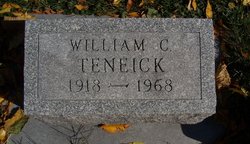
William Charles Ten Eick
| Birth | : | 23 Jan 1918 |
| Death | : | 27 Nov 1968 |
| Burial | : | St Kenelm Churchyard, Alderley, Stroud District, England |
| Coordinate | : | 51.6155170, -2.3357530 |
| Description | : | Iowa City Press-Citizen November 29, 1968 William C. TenEick, 50, of Davenport, a former Iowa Citian, died Wednesday at a Davenport hospital after a long illness. Services will be at 3 p.m. Saturday at the Donohue Mortuary with the Rev. D. L. Schuldt of First Methodist Church officiating. Burial will be in Brick Chapel Cemetery. Friends may call at the funeral home beginning at 11 a.m. Saturday. Mr. TenEick was born Jan. 23, 1918, to Joseph W. and Bessie Anderson TenEick. He married Maxine Teefy of Iowa City at Lebanon, Mo. A watch maker, he... Read More |
frequently asked questions (FAQ):
-
Where is William Charles Ten Eick's memorial?
William Charles Ten Eick's memorial is located at: St Kenelm Churchyard, Alderley, Stroud District, England.
-
When did William Charles Ten Eick death?
William Charles Ten Eick death on 27 Nov 1968 in
-
Where are the coordinates of the William Charles Ten Eick's memorial?
Latitude: 51.6155170
Longitude: -2.3357530
Family Members:
Spouse
Flowers:
Nearby Cemetories:
1. St Kenelm Churchyard
Alderley, Stroud District, England
Coordinate: 51.6155170, -2.3357530
2. Hillesley Baptist Churchyard
Hillesley, Stroud District, England
Coordinate: 51.6054787, -2.3318073
3. Kingswood Abbey
Kingswood, Stroud District, England
Coordinate: 51.6264381, -2.3667738
4. Wotton Baptist Churchyard
Wotton-under-Edge, Stroud District, England
Coordinate: 51.6371850, -2.3531940
5. St. Mary the Virgin Churchyard
Wotton-under-Edge, Stroud District, England
Coordinate: 51.6390390, -2.3480250
6. St Nicholas Churchyard
Ozleworth, Cotswold District, England
Coordinate: 51.6380070, -2.2986530
7. St Mary Churchyard
Hawkesbury, South Gloucestershire Unitary Authority, England
Coordinate: 51.5807290, -2.3359910
8. Holy Trinity Churchyard
Wickwar, South Gloucestershire Unitary Authority, England
Coordinate: 51.5985120, -2.4006930
9. North Nibley Cemetery
North Nibley, Stroud District, England
Coordinate: 51.6584100, -2.3768600
10. Horton Church Cemetery
Horton, South Gloucestershire Unitary Authority, England
Coordinate: 51.5647100, -2.3388100
11. St James the Elder Churchyard
Horton, South Gloucestershire Unitary Authority, England
Coordinate: 51.5637860, -2.3390110
12. Leighterton Church Cemetery
Leighterton, Cotswold District, England
Coordinate: 51.6176900, -2.2518400
13. St Martin Churchyard
North Nibley, Stroud District, England
Coordinate: 51.6629860, -2.3836650
14. St Leonard Churchyard
Tortworth, Stroud District, England
Coordinate: 51.6379440, -2.4286650
15. St Marks Churchyard
Dursley, Stroud District, England
Coordinate: 51.6777900, -2.3499800
16. St Michael and All Angels Churchyard
Little Badminton, South Gloucestershire Unitary Authority, England
Coordinate: 51.5572610, -2.2888360
17. St. John the Baptist Churchyard
Kingscote, Cotswold District, England
Coordinate: 51.6644230, -2.2640480
18. St James the Great Church
Dursley, Stroud District, England
Coordinate: 51.6812840, -2.3530000
19. Dursley Tabernacle URC
Dursley, Stroud District, England
Coordinate: 51.6823727, -2.3571669
20. St Andrew Churchyard
Cromhall, South Gloucestershire Unitary Authority, England
Coordinate: 51.6121930, -2.4456930
21. St Giles Churchyard
Uley, Stroud District, England
Coordinate: 51.6853115, -2.3038214
22. Holy Cross Churchyard
Owlpen, Stroud District, England
Coordinate: 51.6841176, -2.2912175
23. Dursley Town Cemetery
Dursley, Stroud District, England
Coordinate: 51.6893700, -2.3623400
24. Cam Congregational Church
Cam, Stroud District, England
Coordinate: 51.6914518, -2.3530424


