
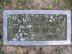
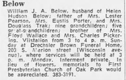
William J.A. Below
| Birth | : | 20 Jul 1886 Terril, Dickinson County, Iowa, USA |
| Death | : | 2 Nov 1968 Oak Park, Cook County, Illinois, USA |
| Burial | : | Croston Cemetery, Croston, Chorley Borough, England |
| Coordinate | : | 53.6586700, -2.7733100 |
| Plot | : | Section: 30 Lot:005 |
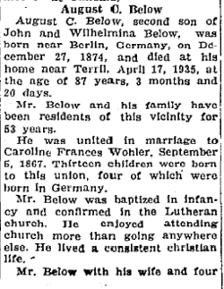
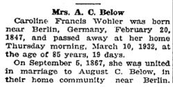
| Description | : | Date of Burial: 11/4/1968, Military: none, Race: White, Father: August Christian, Mother: Caroline Wohler, Cause of death: Cerebral Thrombosis, Occupation: Retired Book Keeper Ref: Cemetery Records |
frequently asked questions (FAQ):
-
Where is William J.A. Below's memorial?
William J.A. Below's memorial is located at: Croston Cemetery, Croston, Chorley Borough, England.
-
When did William J.A. Below death?
William J.A. Below death on 2 Nov 1968 in Oak Park, Cook County, Illinois, USA
-
Where are the coordinates of the William J.A. Below's memorial?
Latitude: 53.6586700
Longitude: -2.7733100
Family Members:
Parent
Spouse
Siblings

Flowers:


Nearby Cemetories:
1. Croston Cemetery
Croston, Chorley Borough, England
Coordinate: 53.6586700, -2.7733100
2. St. John the Baptist Churchyard
Bretherton, Chorley Borough, England
Coordinate: 53.6776300, -2.7952200
3. St Mary the Virgin Churchyard
Eccleston, Chorley Borough, England
Coordinate: 53.6528800, -2.7331920
4. Congregational Church
Bretherton, Chorley Borough, England
Coordinate: 53.6780260, -2.7986920
5. St. Mary the Virgin Churchyard
Rufford, West Lancashire District, England
Coordinate: 53.6349960, -2.8126410
6. St. Mary's Churchyard
Tarleton, West Lancashire District, England
Coordinate: 53.6746100, -2.8239200
7. St. Peter's Churchyard
Mawdesley, Chorley Borough, England
Coordinate: 53.6237600, -2.7734100
8. St. Peter and St. Paul Churchyard
Mawdesley, Chorley Borough, England
Coordinate: 53.6266580, -2.7451420
9. Saint James Churchyard
Leyland, South Ribble Borough, England
Coordinate: 53.6896630, -2.7327430
10. Woodland Burial Ground
Much Hoole, South Ribble Borough, England
Coordinate: 53.6986390, -2.7974440
11. St. Michael and All Angel Churchyard
Much Hoole, South Ribble Borough, England
Coordinate: 53.6942950, -2.8143830
12. Much Hoole Methodist Burial Ground
Much Hoole, South Ribble Borough, England
Coordinate: 53.7053750, -2.7951470
13. St Mary's Roman Catholic Churchyard
Leyland, South Ribble Borough, England
Coordinate: 53.6880510, -2.6983240
14. St. James the Great Churchyard
Wrightington, West Lancashire District, England
Coordinate: 53.6168220, -2.7175670
15. Saint Andrews Churchyard
Leyland, South Ribble Borough, England
Coordinate: 53.6881270, -2.6957880
16. Becconsall Old Church Churchyard
Hesketh with Becconsall, West Lancashire District, England
Coordinate: 53.7023610, -2.8314810
17. St. Mary's Churchyard
Euxton, Chorley Borough, England
Coordinate: 53.6669580, -2.6768350
18. Charnock Richard Crematorium
Chorley, Chorley Borough, England
Coordinate: 53.6518550, -2.6763080
19. Euxton Parish Churchyard
Euxton, Chorley Borough, England
Coordinate: 53.6650950, -2.6743630
20. All Saints Churchyard
Hesketh with Becconsall, West Lancashire District, England
Coordinate: 53.7028189, -2.8400142
21. Christ Church
Charnock Richard, Chorley Borough, England
Coordinate: 53.6367200, -2.6773400
22. St John the Baptist Churchyard
Burscough, West Lancashire District, England
Coordinate: 53.6042760, -2.8401390
23. Our Lady and All Saints Roman Catholic
Parbold, West Lancashire District, England
Coordinate: 53.5911900, -2.7644350
24. St. Andrew's Churchyard
Longton, South Ribble Borough, England
Coordinate: 53.7263889, -2.7822222