
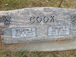

William Joseph “Bill” Cook
| Birth | : | 5 Jun 1910 Albion, Boone County, Nebraska, USA |
| Death | : | 5 May 2002 Albion, Boone County, Nebraska, USA |
| Burial | : | Sleaford Cemetery, Sleaford, North Kesteven District, England |
| Coordinate | : | 53.0027590, -0.4056790 |
| Description | : | Son of Joseph & Hazel (Stoakes) Cook. Married to Thelma Schoening on 6-30-1936 at Belgrade, NE. US Navy Veteran - 11-18-1944/1-19-1946. After his discharge, he returned to Albion where he opened Cook's Radio Service. In the late 1940s, he brought the first television to the community and began selling and servicing televisions and other appliances. He also owned and operated the Rex Movie Theater from the 1940s to 1960s. |
frequently asked questions (FAQ):
-
Where is William Joseph “Bill” Cook's memorial?
William Joseph “Bill” Cook's memorial is located at: Sleaford Cemetery, Sleaford, North Kesteven District, England.
-
When did William Joseph “Bill” Cook death?
William Joseph “Bill” Cook death on 5 May 2002 in Albion, Boone County, Nebraska, USA
-
Where are the coordinates of the William Joseph “Bill” Cook's memorial?
Latitude: 53.0027590
Longitude: -0.4056790
Family Members:
Parent

Spouse

Siblings

Flowers:


Nearby Cemetories:
1. Sleaford Cemetery
Sleaford, North Kesteven District, England
Coordinate: 53.0027590, -0.4056790
2. St Denys Churchyard
Sleaford, North Kesteven District, England
Coordinate: 52.9996510, -0.4088960
3. St Botolph Churchyard
Quarrington, North Kesteven District, England
Coordinate: 52.9872010, -0.4312350
4. St Andrew Churchyard
Leasingham, North Kesteven District, England
Coordinate: 53.0239040, -0.4262600
5. St. Denys Churchyard
Kirkby la Thorpe, North Kesteven District, England
Coordinate: 53.0008270, -0.3636800
6. St. Denis Churchyard
Silk Willoughby, North Kesteven District, England
Coordinate: 52.9738460, -0.4268830
7. St Denys Churchyard
Silk Willoughby, North Kesteven District, England
Coordinate: 52.9736976, -0.4263297
8. Rauceby Hospital Cemetery
Quarrington, North Kesteven District, England
Coordinate: 52.9807077, -0.4549731
9. St. Andrew's Churchyard
Asgarby, North Kesteven District, England
Coordinate: 52.9941750, -0.3383450
10. St Peter's Churchyard
North Rauceby, North Kesteven District, England
Coordinate: 53.0056400, -0.4796500
11. All Saints Churchyard
Ruskington, North Kesteven District, England
Coordinate: 53.0460330, -0.3866280
12. St Andrew Churchyard
Cranwell, North Kesteven District, England
Coordinate: 53.0370660, -0.4612070
13. St Edith's Church
Anwick, North Kesteven District, England
Coordinate: 53.0414520, -0.3391170
14. Anwick Church Lane Churchyard Extension
Anwick, North Kesteven District, England
Coordinate: 53.0420800, -0.3397200
15. St. Andrew's Churchyard
Scredington, North Kesteven District, England
Coordinate: 52.9498300, -0.3701700
16. St. Andrew Churchyard
Burton Pedwardine, North Kesteven District, England
Coordinate: 52.9646176, -0.3348618
17. St. Oswald's Churchyard
Howell, North Kesteven District, England
Coordinate: 53.0016300, -0.3100400
18. All Saints Churchyard
Brauncewell, North Kesteven District, England
Coordinate: 53.0587900, -0.4418200
19. St. Mary's Churchyard
Wilsford, North Kesteven District, England
Coordinate: 52.9751600, -0.5023700
20. St. Andrew's Churchyard
Heckington, North Kesteven District, England
Coordinate: 52.9822000, -0.2990800
21. St Thomas Churchyard
Aunsby, North Kesteven District, England
Coordinate: 52.9367820, -0.4470450
22. Heckington Cemetery
Heckington, North Kesteven District, England
Coordinate: 52.9803830, -0.2920010
23. St Peter & St Paul Churchyard
Osbournby, North Kesteven District, England
Coordinate: 52.9298800, -0.4105100
24. St Andrew Churchyard
Kelby, North Kesteven District, England
Coordinate: 52.9608000, -0.5074000