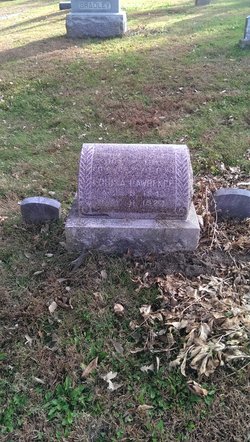
William P Lawrence
| Birth | : | 8 Nov 1834 Morgan County, Ohio, USA |
| Death | : | 2 Oct 1911 Mount Etna, Adams County, Iowa, USA |
| Burial | : | Springston Cemetery, Lincoln, Selwyn District, New Zealand |
| Coordinate | : | -43.6404360, 172.4509420 |
| Description | : | W. P. Lawrence, of Carl township, died at his home Monday, October 2, 1911, being aged 76 years, 10 months and 24 days. The funeral was held today at the First Baptist church in Washington township, conducted by Rev. A. K. Lewis, and interment was made in the Baptist cemetery nearby. W. P. Lawrence was born in Morgan County, Ohio, November 8, 1834. He was a soldier in the civil war, enlisting October 15, 1862, in Muskingum County, Ohio, in company C 122nd Ohio volunteer infantry. He was honorably discharged June 26, 1865. In 1867 he came from Ohio to Adams... Read More |
frequently asked questions (FAQ):
-
Where is William P Lawrence's memorial?
William P Lawrence's memorial is located at: Springston Cemetery, Lincoln, Selwyn District, New Zealand.
-
When did William P Lawrence death?
William P Lawrence death on 2 Oct 1911 in Mount Etna, Adams County, Iowa, USA
-
Where are the coordinates of the William P Lawrence's memorial?
Latitude: -43.6404360
Longitude: 172.4509420
Family Members:
Spouse
Children
Flowers:
Nearby Cemetories:
1. Springston Cemetery
Lincoln, Selwyn District, New Zealand
Coordinate: -43.6404360, 172.4509420
2. St Mary's Churchyard
Springston, Selwyn District, New Zealand
Coordinate: -43.6446560, 172.4263590
3. Lincoln Cemetery
Lincoln, Selwyn District, New Zealand
Coordinate: -43.6311790, 172.4862570
4. Prebbleton Cemetery
Prebbleton, Selwyn District, New Zealand
Coordinate: -43.5887200, 172.5053500
5. Shands Road Cemetery
Prebbleton, Selwyn District, New Zealand
Coordinate: -43.5792540, 172.4888630
6. All Saint's Churchyard
Prebbleton, Selwyn District, New Zealand
Coordinate: -43.5781040, 172.5131430
7. Weedons Cemetery
Weedons, Selwyn District, New Zealand
Coordinate: -43.5670010, 172.4015870
8. St Saviours Churchyard
Templeton, Christchurch City, New Zealand
Coordinate: -43.5501420, 172.4714620
9. St. Mary's Anglican Church Cemetery
Halswell, Christchurch City, New Zealand
Coordinate: -43.5794830, 172.5686440
10. Mount Magdala Cemetery
Halswell, Christchurch City, New Zealand
Coordinate: -43.5622700, 172.5672600
11. St Luke's Anglican Churchyard
Brookside, Selwyn District, New Zealand
Coordinate: -43.6903100, 172.3029000
12. St Paul's Anglican Church Cemetery
West Melton, Selwyn District, New Zealand
Coordinate: -43.5261700, 172.3701800
13. Yaldhurst Cemetery
Yaldhurst, Christchurch City, New Zealand
Coordinate: -43.5109640, 172.4765980
14. Church of the Epiphany Churchyard
Teddington, Christchurch City, New Zealand
Coordinate: -43.7016200, 172.6182200
15. Brookside Cemetery
Brookside, Selwyn District, New Zealand
Coordinate: -43.6751800, 172.2683700
16. St Peter's Anglican Churchyard
Upper Riccarton, Christchurch City, New Zealand
Coordinate: -43.5317570, 172.5701330
17. St Cuthbert's Cemetery
Governors Bay, Christchurch City, New Zealand
Coordinate: -43.6326900, 172.6458000
18. Avonhead Memorial Cemetery
Avonhead, Christchurch City, New Zealand
Coordinate: -43.5095390, 172.5503920
19. Sydenham Cemetery
Sydenham, Christchurch City, New Zealand
Coordinate: -43.5582330, 172.6254900
20. St Peters Churchyard
Teddington, Christchurch City, New Zealand
Coordinate: -43.6719000, 172.6590100
21. Addington Cemetery
Addington, Christchurch City, New Zealand
Coordinate: -43.5434880, 172.6235790
22. Halkett Presbyterian Churchyard
Halkett, Selwyn District, New Zealand
Coordinate: -43.5011000, 172.3220900
23. Waimairi Cemetery
Burnside, Christchurch City, New Zealand
Coordinate: -43.4997760, 172.5773860
24. Blessed Sacrament Cathedral
Christchurch, Christchurch City, New Zealand
Coordinate: -43.5384250, 172.6458880


