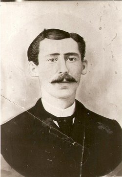
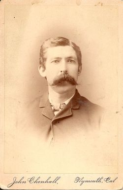
William Richard Clemence
| Birth | : | 10 Feb 1859 St Austell, Cornwall Unitary Authority, Cornwall, England |
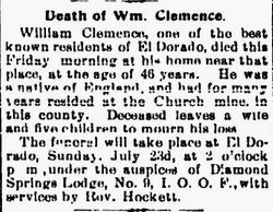
| Death | : | 21 Jul 1905 El Dorado, El Dorado County, California, USA |
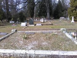
| Burial | : | El Dorado Cemetery, El Dorado, El Dorado County, USA |
| Coordinate | : | 38.6804085, -120.8490067 |
| Plot | : | sec 1 row 4 plot 20 |
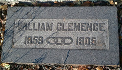
| Inscription | : | WILLIAM CLEMENCE, 1859 OOO 1905 |
| Description | : | 1859, Feb 10 ---- BIRTH (date and location), MARRIAGE, DEATH: {FamilySearch.org} BIRTHPLACE: ST. AUSTELL: “Named after it’s patron Saint, the Parish is in Restormel district. St Austell is a market town situated approximately 14 miles to the North East of Truro, it is not mentioned in the Domesday Book. The town is a small country town near to the local china clay industry. The Southern edge of the parish is the coastline around St Austell Bay. The main industries of the area are china clay extraction, and farming. There is a brewery in the town. A number of villages... Read More |
frequently asked questions (FAQ):
-
Where is William Richard Clemence's memorial?
William Richard Clemence's memorial is located at: El Dorado Cemetery, El Dorado, El Dorado County, USA.
-
When did William Richard Clemence death?
William Richard Clemence death on 21 Jul 1905 in El Dorado, El Dorado County, California, USA
-
Where are the coordinates of the William Richard Clemence's memorial?
Latitude: 38.6804085
Longitude: -120.8490067
Family Members:
Parent
Spouse
Siblings
Children
Flowers:
Nearby Cemetories:
1. El Dorado Cemetery
El Dorado, El Dorado County, USA
Coordinate: 38.6804085, -120.8490067
2. Kingsville Cemetery
El Dorado, El Dorado County, USA
Coordinate: 38.6993870, -120.8516060
3. Carpenter Family Residence Burial Plot
Diamond Springs, El Dorado County, USA
Coordinate: 38.6941590, -120.8187750
4. Diamond Springs Cemetery
Diamond Springs, El Dorado County, USA
Coordinate: 38.6940960, -120.8186620
5. Greenstone Cemetery
Shingle Springs, El Dorado County, USA
Coordinate: 38.6749020, -120.8869240
6. Odd Fellows Cemetery
Diamond Springs, El Dorado County, USA
Coordinate: 38.6963882, -120.8151932
7. Missouri Flat Cemetery
Placerville, El Dorado County, USA
Coordinate: 38.7157360, -120.8403400
8. Weberville Cemetery
Placerville, El Dorado County, USA
Coordinate: 38.7024170, -120.7901000
9. Heusner Ranch Family Cemetery
Buckeye, El Dorado County, USA
Coordinate: 38.6675770, -120.9135260
10. Meyer-Zentgraf Cemetery
Shingle Springs, El Dorado County, USA
Coordinate: 38.6710620, -120.9158490
11. Old Placerville City Cemetery
Placerville, El Dorado County, USA
Coordinate: 38.7258987, -120.8059464
12. Middletown Cemetery
Placerville, El Dorado County, USA
Coordinate: 38.7358704, -120.8301010
13. Old Saint Patricks Cemetery
Placerville, El Dorado County, USA
Coordinate: 38.7249107, -120.8024673
14. Westwood Hills Memorial Park Pet Cemetery
Placerville, El Dorado County, USA
Coordinate: 38.7365210, -120.8323130
15. Westwood Hills Memorial Park
Placerville, El Dorado County, USA
Coordinate: 38.7367363, -120.8326035
16. Jewish Pioneer Cemetery
Placerville, El Dorado County, USA
Coordinate: 38.7299500, -120.8091965
17. Boles Family Cemetery
Placerville, El Dorado County, USA
Coordinate: 38.7309860, -120.8069580
18. Placerville Union Cemetery
Placerville, El Dorado County, USA
Coordinate: 38.7317390, -120.8084106
19. Saint Patrick Cemetery
Placerville, El Dorado County, USA
Coordinate: 38.7327995, -120.8047638
20. Shingle Springs Cemetery
Shingle Springs, El Dorado County, USA
Coordinate: 38.6648903, -120.9270325
21. Frenchtown Cemetery
Frenchtown, El Dorado County, USA
Coordinate: 38.6421585, -120.9132309
22. Methodist Episcopal Federated Cemetery
Placerville, El Dorado County, USA
Coordinate: 38.7283287, -120.7942200
23. County Hospital Cemetery
Placerville, El Dorado County, USA
Coordinate: 38.7342796, -120.8028488
24. Cold Springs Cemetery
Cold Springs, El Dorado County, USA
Coordinate: 38.7441444, -120.8721619

