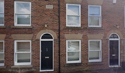
| Memorials | : | 0 |
| Location | : | Nantwich, Cheshire East Unitary Authority, England |
| Coordinate | : | 53.0658770, -2.5222890 |
| Description | : | In 1772 "the Baptist cause fell on hard times and the Chapel closed" only to be leased, five years later, to the local Methodist Society. John Wesley preached there three times - in 1779, 1780 and 1781. About 1812, the Baptist cause was revived but later, in a row over it having been used by another denomination, the chapel was closed and remained so for 40 years until 1862. It was officially reopened, after repairs, in 1865 and was used by the Baptists until they moved to Market Street in 1873. The building was then used by the Order of... Read More |
frequently asked questions (FAQ):
-
Where is Barker Street Chapel Chapelyard?
Barker Street Chapel Chapelyard is located at Barker Street Nantwich, Cheshire East Unitary Authority ,Cheshire ,England.
-
Barker Street Chapel Chapelyard cemetery's updated grave count on graveviews.com?
0 memorials
-
Where are the coordinates of the Barker Street Chapel Chapelyard?
Latitude: 53.0658770
Longitude: -2.5222890
Nearby Cemetories:
1. Nantwich Quaker Burial Ground (Defunct)
Nantwich, Cheshire East Unitary Authority, England
Coordinate: 53.0645719, -2.5214206
2. St Mary's Church
Nantwich, Cheshire East Unitary Authority, England
Coordinate: 53.0671000, -2.5206000
3. Nantwich Cemetery
Nantwich, Cheshire East Unitary Authority, England
Coordinate: 53.0765120, -2.5108130
4. St Mary Churchyard
Acton, Cheshire East Unitary Authority, England
Coordinate: 53.0737140, -2.5511740
5. St Mary's Churchyard
Wistaston, Cheshire East Unitary Authority, England
Coordinate: 53.0790200, -2.4771400
6. St Oswald Churchyard
Worleston, Cheshire East Unitary Authority, England
Coordinate: 53.1072140, -2.5223120
7. Quaker Burial Ground at Stoke Nantwich
Stoke, Cheshire East Unitary Authority, England
Coordinate: 53.0989400, -2.5670000
8. St Michael Churchyard
Baddiley, Cheshire East Unitary Authority, England
Coordinate: 53.0488780, -2.5905830
9. St. Chad Churchyard
Wybunbury, Cheshire East Unitary Authority, England
Coordinate: 53.0452760, -2.4488530
10. Meadow Brook Cemetery
Crewe, Cheshire East Unitary Authority, England
Coordinate: 53.1083460, -2.4690380
11. St. Michael Churchyard
Crewe, Cheshire East Unitary Authority, England
Coordinate: 53.1058200, -2.4475200
12. Crewe Cemetery & Crematorium
Crewe, Cheshire East Unitary Authority, England
Coordinate: 53.1030540, -2.4415159
13. St Margaret Churchyard
Wrenbury-cum-Frith, Cheshire East Unitary Authority, England
Coordinate: 53.0256700, -2.6073340
14. Weston Cemetery
Weston, Cheshire East Unitary Authority, England
Coordinate: 53.0680861, -2.4095799
15. Bateman Memorial Chapel
Chorley, Cheshire East Unitary Authority, England
Coordinate: 53.0549000, -2.6368300
16. St Peter Churchyard
Minshull Vernon, Cheshire East Unitary Authority, England
Coordinate: 53.1308770, -2.4772320
17. St Michael's
Haslington, Cheshire East Unitary Authority, England
Coordinate: 53.0946170, -2.4097820
18. St Bartholomew's Churchyard
Church Minshull, Cheshire East Unitary Authority, England
Coordinate: 53.1414200, -2.5007800
19. St. Matthew's Churchyard
Haslington, Cheshire East Unitary Authority, England
Coordinate: 53.1011010, -2.3933740
20. St. Boniface Churchyard
Bunbury, Cheshire East Unitary Authority, England
Coordinate: 53.1182360, -2.6453990
21. St. Leonard's Churchyard
Warmingham, Cheshire East Unitary Authority, England
Coordinate: 53.1462213, -2.4367574
22. Weaver Methodist Church Cemetery
Winsford, Cheshire West and Chester Unitary Authority, England
Coordinate: 53.1652870, -2.5207080
23. St Margaret Churchyard
Betley, Newcastle-Under-Lyme Borough, England
Coordinate: 53.0328100, -2.3658530
24. St Michael Churchyard
Marbury-cum-Quoisley, Cheshire East Unitary Authority, England
Coordinate: 53.0062980, -2.6564160

