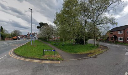
| Memorials | : | 0 |
| Location | : | Nantwich, Cheshire East Unitary Authority, England |
| Coordinate | : | 53.0645719, -2.5214206 |
| Description | : | According to the historian James Hall, writing in 1883, "The Nantwich Friends' Meeting-House, and Burial Ground, is situated in Pillory Street. The land, about eight hundred and twenty-one square yards, was conveyed in 1724 to Benjamin Claridge, of Winsford, and another, together with some buildings thereon, in trust for the use of the people called Quakers, ... Read More |
frequently asked questions (FAQ):
-
Where is Nantwich Quaker Burial Ground (Defunct)?
Nantwich Quaker Burial Ground (Defunct) is located at 17 Love Lane Nantwich, Cheshire East Unitary Authority ,Cheshire , CW5 5BHEngland.
-
Nantwich Quaker Burial Ground (Defunct) cemetery's updated grave count on graveviews.com?
0 memorials
-
Where are the coordinates of the Nantwich Quaker Burial Ground (Defunct)?
Latitude: 53.0645719
Longitude: -2.5214206
Nearby Cemetories:
1. Barker Street Chapel Chapelyard
Nantwich, Cheshire East Unitary Authority, England
Coordinate: 53.0658770, -2.5222890
2. St Mary's Church
Nantwich, Cheshire East Unitary Authority, England
Coordinate: 53.0671000, -2.5206000
3. Nantwich Cemetery
Nantwich, Cheshire East Unitary Authority, England
Coordinate: 53.0765120, -2.5108130
4. St Mary Churchyard
Acton, Cheshire East Unitary Authority, England
Coordinate: 53.0737140, -2.5511740
5. St Mary's Churchyard
Wistaston, Cheshire East Unitary Authority, England
Coordinate: 53.0790200, -2.4771400
6. St Oswald Churchyard
Worleston, Cheshire East Unitary Authority, England
Coordinate: 53.1072140, -2.5223120
7. Quaker Burial Ground at Stoke Nantwich
Stoke, Cheshire East Unitary Authority, England
Coordinate: 53.0989400, -2.5670000
8. St Michael Churchyard
Baddiley, Cheshire East Unitary Authority, England
Coordinate: 53.0488780, -2.5905830
9. St. Chad Churchyard
Wybunbury, Cheshire East Unitary Authority, England
Coordinate: 53.0452760, -2.4488530
10. Meadow Brook Cemetery
Crewe, Cheshire East Unitary Authority, England
Coordinate: 53.1083460, -2.4690380
11. St. Michael Churchyard
Crewe, Cheshire East Unitary Authority, England
Coordinate: 53.1058200, -2.4475200
12. Crewe Cemetery & Crematorium
Crewe, Cheshire East Unitary Authority, England
Coordinate: 53.1030540, -2.4415159
13. St Margaret Churchyard
Wrenbury-cum-Frith, Cheshire East Unitary Authority, England
Coordinate: 53.0256700, -2.6073340
14. Weston Cemetery
Weston, Cheshire East Unitary Authority, England
Coordinate: 53.0680861, -2.4095799
15. Bateman Memorial Chapel
Chorley, Cheshire East Unitary Authority, England
Coordinate: 53.0549000, -2.6368300
16. St Peter Churchyard
Minshull Vernon, Cheshire East Unitary Authority, England
Coordinate: 53.1308770, -2.4772320
17. St Michael's
Haslington, Cheshire East Unitary Authority, England
Coordinate: 53.0946170, -2.4097820
18. St Bartholomew's Churchyard
Church Minshull, Cheshire East Unitary Authority, England
Coordinate: 53.1414200, -2.5007800
19. St. Matthew's Churchyard
Haslington, Cheshire East Unitary Authority, England
Coordinate: 53.1011010, -2.3933740
20. St. Boniface Churchyard
Bunbury, Cheshire East Unitary Authority, England
Coordinate: 53.1182360, -2.6453990
21. St. Leonard's Churchyard
Warmingham, Cheshire East Unitary Authority, England
Coordinate: 53.1462213, -2.4367574
22. St Margaret Churchyard
Betley, Newcastle-Under-Lyme Borough, England
Coordinate: 53.0328100, -2.3658530
23. St Michael Churchyard
Marbury-cum-Quoisley, Cheshire East Unitary Authority, England
Coordinate: 53.0062980, -2.6564160
24. Weaver Methodist Church Cemetery
Winsford, Cheshire West and Chester Unitary Authority, England
Coordinate: 53.1652870, -2.5207080

