
| Memorials | : | 0 |
| Location | : | Chertsey, Runnymede Borough, England |
| Coordinate | : | 51.3781700, -0.5831300 |
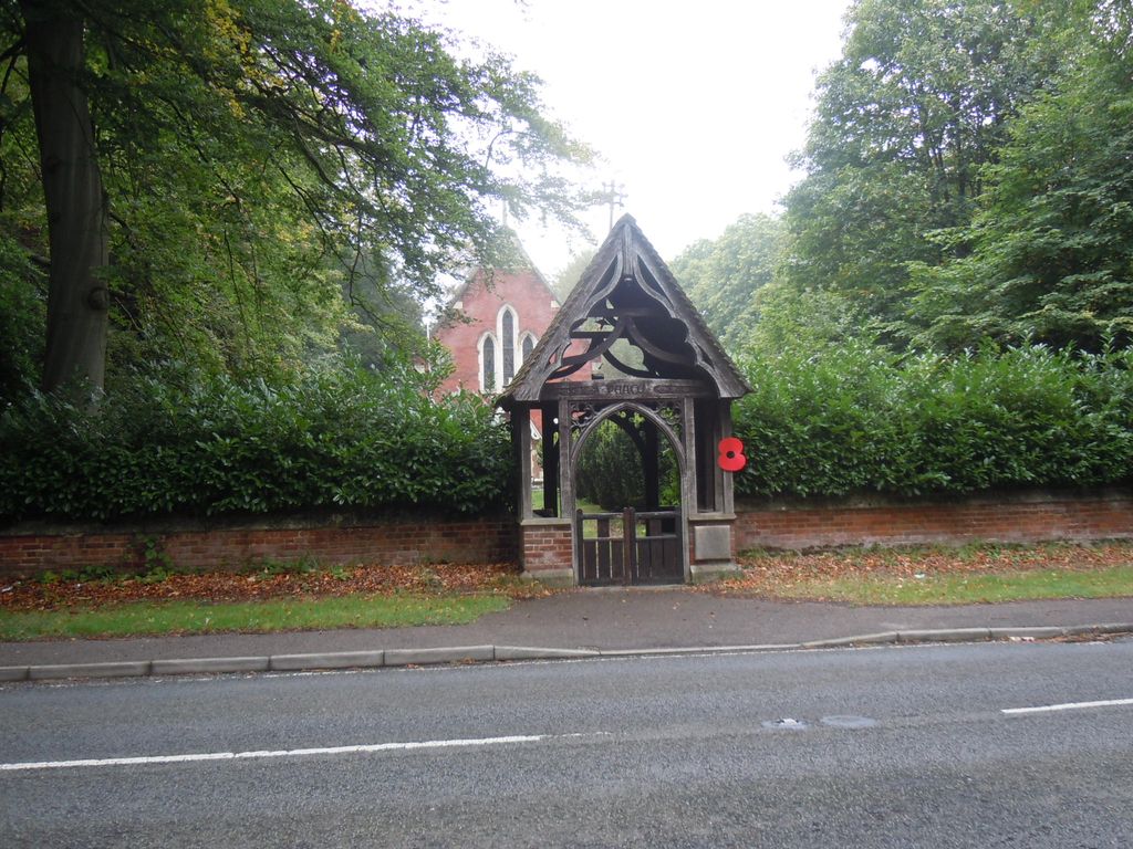
| Description | : | Christ Church, Longcross, Chertsey, Surrey is located on Longcross Road (B386) about 6km from Chertsey and close to Chobham Common. The church has been registered for disposal and the parish has merged with the parish of Lyne. The church is a Grade II listed building of mid-Victorian (1847) origin comprising a nave, west porch, chancel, north organ chamber, and vestry. It is built of red brick with slate roofs. The cemetery surrounds the church. The Lych gate marking the entrance was erected in memory of Sub-Lieutenant Cyril J A Mullens RNVR who died in action in WW1 on... Read More |
frequently asked questions (FAQ):
-
Where is Christ Church?
Christ Church is located at Longcross Road Chertsey, Runnymede Borough ,Surrey , KT16 0DUEngland.
-
Christ Church cemetery's updated grave count on graveviews.com?
0 memorials
-
Where are the coordinates of the Christ Church?
Latitude: 51.3781700
Longitude: -0.5831300
Nearby Cemetories:
1. Christ Church Churchyard
Virginia Water, Runnymede Borough, England
Coordinate: 51.4073160, -0.5796440
2. Valley End St Saviour Churchyard
Chobham, Surrey Heath Borough, England
Coordinate: 51.3647100, -0.6317100
3. Christ Church Cemetery
Ottershaw, Runnymede Borough, England
Coordinate: 51.3610140, -0.5353310
4. Holy Trinity Churchyard
Sunningdale, Windsor and Maidenhead Royal Borough, England
Coordinate: 51.3989170, -0.6304810
5. Sunningdale Cemetery
Sunningdale, Windsor and Maidenhead Royal Borough, England
Coordinate: 51.4021820, -0.6322850
6. St Marys Churchyard
Thorpe, Runnymede Borough, England
Coordinate: 51.4075720, -0.5293820
7. Englefield Green Cemetery
Englefield Green, Runnymede Borough, England
Coordinate: 51.4273640, -0.5730490
8. Addlestone Cemetery
Addlestone, Runnymede Borough, England
Coordinate: 51.3780880, -0.5031800
9. Holy Trinity Churchyard
West End, Surrey Heath Borough, England
Coordinate: 51.3434880, -0.6420670
10. St Michael and All Angels Churchyard
Sunninghill, Windsor and Maidenhead Royal Borough, England
Coordinate: 51.4000090, -0.6570340
11. St Paul's Churchyard
Addlestone, Runnymede Borough, England
Coordinate: 51.3687400, -0.5027050
12. St. Peter's Churchyard
Chertsey, Runnymede Borough, England
Coordinate: 51.3924010, -0.5036640
13. Chertsey Cemetery
Chertsey, Runnymede Borough, England
Coordinate: 51.3849600, -0.5009760
14. Chertsey Abbey (Defunct)
Chertsey, Runnymede Borough, England
Coordinate: 51.3950000, -0.5031000
15. Windlesham Cemetery
Windlesham, Surrey Heath Borough, England
Coordinate: 51.3654000, -0.6654900
16. St Mary the Virgin Churchyard
Horsell, Woking Borough, England
Coordinate: 51.3227460, -0.5703770
17. St. John the Baptist Churchyard
Bisley, Surrey Heath Borough, England
Coordinate: 51.3273600, -0.6266370
18. St. John the Baptist Churchyard
Egham, Runnymede Borough, England
Coordinate: 51.4327120, -0.5443380
19. Runnymede Memorial
Englefield Green, Runnymede Borough, England
Coordinate: 51.4378433, -0.5649990
20. All Souls Churchyard
South Ascot, Windsor and Maidenhead Royal Borough, England
Coordinate: 51.4035450, -0.6745890
21. St John the Baptist Church
West Byfleet, Woking Borough, England
Coordinate: 51.3383570, -0.5023990
22. All Saints Churchyard
Laleham, Spelthorne Borough, England
Coordinate: 51.4091880, -0.4898680
23. Woking Crematorium
Woking, Woking Borough, England
Coordinate: 51.3122590, -0.6022630
24. St John the Baptist Churchyard
St Johns, Woking Borough, England
Coordinate: 51.3104700, -0.5929170