
| Memorials | : | 0 |
| Location | : | Downton, Wiltshire Unitary Authority, England |
| Coordinate | : | 51.0106010, -1.7411390 |
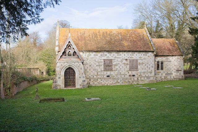
| Description | : | The church, dedicated to St. Mary, is thought to have been newly founded in 1147 as a daughter church of Downton. After the settlement at Standlynch disappeared in the late In the early 17th century the the lords of Standlynch manor were Roman Catholics and may have used the church for masses. It was rebuilt in 1677 by Maurice Buckland, then lord of the manor, although part of the late medieval chancel survives. It remained a private chapel. It is of flint and stone in chequer pattern with a nave and chancel only. In the 19th century services were conducted... Read More |
frequently asked questions (FAQ):
-
Where is Church of St. Michael and All the Angels?
Church of St. Michael and All the Angels is located at Trafalgar Park, Standlynch, Downton Downton, Wiltshire Unitary Authority ,Wiltshire , SP5 3QREngland.
-
Church of St. Michael and All the Angels cemetery's updated grave count on graveviews.com?
0 memorials
-
Where are the coordinates of the Church of St. Michael and All the Angels?
Latitude: 51.0106010
Longitude: -1.7411390
Nearby Cemetories:
1. St Mary's Churchyard
Alderbury, Wiltshire Unitary Authority, England
Coordinate: 51.0413780, -1.7413140
2. St Mary Churchyard
Hale, New Forest District, England
Coordinate: 50.9670380, -1.7473110
3. Broad Chalke Congregational Chapelyard
Broad Chalke, Wiltshire Unitary Authority, England
Coordinate: 51.0523805, -1.7071162
4. St. Peter's Churchyard
Britford, Wiltshire Unitary Authority, England
Coordinate: 51.0551650, -1.7689880
5. St. Mary's Churchyard
Breamore, New Forest District, England
Coordinate: 50.9687400, -1.7834000
6. Woodgreen Cemetery
Woodgreen, New Forest District, England
Coordinate: 50.9525032, -1.7574225
7. St. Leonard's Churchyard
Whitsbury, New Forest District, England
Coordinate: 50.9713900, -1.8176000
8. St. Michael and All Angels Cemetery
Coombe Bissett, Wiltshire Unitary Authority, England
Coordinate: 51.0361120, -1.8473230
9. St. Andrew's Churchyard
Rockbourne, New Forest District, England
Coordinate: 50.9640400, -1.8369600
10. St Andrew Churchyard
Bemerton, Wiltshire Unitary Authority, England
Coordinate: 51.0740580, -1.8252960
11. St. Winfrith Churchyard
East Dean, Test Valley Borough, England
Coordinate: 51.0393480, -1.6115260
12. Bemerton St John
Bemerton, Wiltshire Unitary Authority, England
Coordinate: 51.0759324, -1.8333699
13. Fordingbridge Cemetery
Fordingbridge, New Forest District, England
Coordinate: 50.9253570, -1.7818480
14. St Peter Churchyard
Plaitford, Test Valley Borough, England
Coordinate: 50.9815600, -1.6052890
15. Fordingbridge Methodist Church
Fordingbridge, New Forest District, England
Coordinate: 50.9251012, -1.7948375
16. St. John the Baptist Churchyard
Bishopstone (Salisbury), Wiltshire Unitary Authority, England
Coordinate: 51.0379160, -1.8812960
17. St. Mary the Virgin Churchyard
Fordingbridge, New Forest District, England
Coordinate: 50.9236200, -1.7946300
18. Stuckton Congregational Chapelyard
New Forest District, England
Coordinate: 50.9182358, -1.7740048
19. St. Peter's Churchyard
Bramshaw, New Forest District, England
Coordinate: 50.9485800, -1.6245700
20. St George Churchyard
Damerham, New Forest District, England
Coordinate: 50.9416320, -1.8483240
21. St. Leonard Churchyard
Sherfield English, Test Valley Borough, England
Coordinate: 51.0001130, -1.5875130
22. St. Peter's Churchyard
West Tytherley, Test Valley Borough, England
Coordinate: 51.0662240, -1.6100910
23. Holy Ascension Churchyard
Hyde, New Forest District, England
Coordinate: 50.9115300, -1.7660300
24. All Saints Churchyard
Martin, New Forest District, England
Coordinate: 50.9753760, -1.9009220