
| Memorials | : | 0 |
| Location | : | Brownfield, Oxford County, USA |
| Coordinate | : | 43.9372900, -70.9454100 |
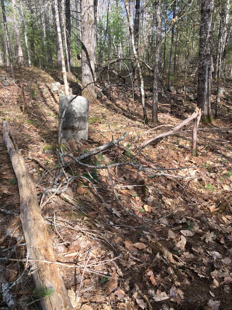
| Description | : | From its intersection with Haleytown Road, drive east on Hampshire (River) Road less than 0.2 miles. Park at a small dirt drive on the left (north) side across from #236. From the small red shack, walk north into the woods about 50 yards. One gravestone is standing next to a stone wall (Edwin Hill) and another is lying embedded in the ground (William Hill). There is no enclosure around the graves. According to Ruth Peckham's notes of Eli Bean's diaries, also buried here are Ada Hill (dau of Rose E. Hill), Jane Hill (wife of William Hill) and an infant... Read More |
frequently asked questions (FAQ):
-
Where is Edwin Hill Cemetery?
Edwin Hill Cemetery is located at Brownfield, Oxford County ,Maine ,USA.
-
Edwin Hill Cemetery cemetery's updated grave count on graveviews.com?
0 memorials
-
Where are the coordinates of the Edwin Hill Cemetery?
Latitude: 43.9372900
Longitude: -70.9454100
Nearby Cemetories:
1. Isaac Johnson Cemetery
Brownfield, Oxford County, USA
Coordinate: 43.9321500, -70.9356200
2. Wentworth-Brown Cemetery
Brownfield, Oxford County, USA
Coordinate: 43.9317200, -70.9555100
3. Merrill Cemetery
Brownfield, Oxford County, USA
Coordinate: 43.9284000, -70.9423100
4. Thomas Cotton Cemetery
Brownfield, Oxford County, USA
Coordinate: 43.9546000, -70.9561500
5. Greenlaw Cemetery
Brownfield, Oxford County, USA
Coordinate: 43.9263992, -70.9677963
6. Brown-Johnson Cemetery
Brownfield, Oxford County, USA
Coordinate: 43.9163710, -70.9617450
7. Pine Grove Cemetery
Brownfield, Oxford County, USA
Coordinate: 43.9375000, -70.9041977
8. Marston Cemetery
Brownfield, Oxford County, USA
Coordinate: 43.9664001, -70.9539032
9. Blake Cemetery
Brownfield, Oxford County, USA
Coordinate: 43.9063988, -70.9514008
10. Ricker Cemetery
Brownfield, Oxford County, USA
Coordinate: 43.9061540, -70.9425500
11. Dennett Cemetery
Brownfield, Oxford County, USA
Coordinate: 43.9289700, -70.9931000
12. Quint Cemetery
Brownfield, Oxford County, USA
Coordinate: 43.8984700, -70.9408400
13. Joseph Meserve Cemetery
Brownfield, Oxford County, USA
Coordinate: 43.9104300, -70.9854200
14. George Hart Cemetery
Eaton Center, Carroll County, USA
Coordinate: 43.9161600, -70.9950900
15. Burnt Meadow Cemetery
Brownfield, Oxford County, USA
Coordinate: 43.9458008, -70.8843994
16. Binford Cemetery
Brownfield, Oxford County, USA
Coordinate: 43.8936250, -70.9597380
17. Gray Gravesite
Eaton Center, Carroll County, USA
Coordinate: 43.9227780, -71.0058330
18. Nathaniel Hill Cemetery
Brownfield, Oxford County, USA
Coordinate: 43.8926100, -70.9615000
19. Cole Cemetery
Brownfield, Oxford County, USA
Coordinate: 43.8956000, -70.9768700
20. Frank Hart Cemetery
Eaton Center, Carroll County, USA
Coordinate: 43.9145100, -71.0039600
21. Thurston-Meserve Cemetery
Eaton, Carroll County, USA
Coordinate: 43.9105100, -71.0027800
22. Johnson Cemetery
Brownfield, Oxford County, USA
Coordinate: 43.8880600, -70.9355600
23. Linscott Cemetery
Brownfield, Oxford County, USA
Coordinate: 43.8984500, -70.9886100
24. Walker-Rounds Cemetery
Brownfield, Oxford County, USA
Coordinate: 43.8909100, -70.9765200