
| Memorials | : | 1 |
| Location | : | Brownfield, Oxford County, USA |
| Coordinate | : | 43.9317200, -70.9555100 |
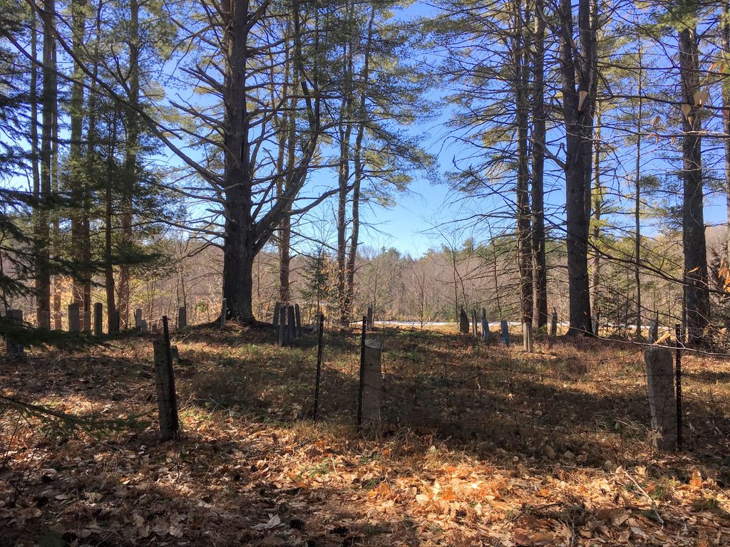
| Description | : | From its intersection with Center Conway Road, drive south on Hampshire (Eaton Center) Road 330 feet until a small drive on the left (east) side of the road. Follow this drive (right at the fork) 500 feet to the cemetery, which sits on a spit of woods raised above the surrounding fields. This cemetery is fenced and most of the stones are standing. Many large pine trees drop their branches around the stones. |
frequently asked questions (FAQ):
-
Where is Wentworth-Brown Cemetery?
Wentworth-Brown Cemetery is located at Hampshire Road Brownfield, Oxford County ,Maine ,USA.
-
Wentworth-Brown Cemetery cemetery's updated grave count on graveviews.com?
1 memorials
-
Where are the coordinates of the Wentworth-Brown Cemetery?
Latitude: 43.9317200
Longitude: -70.9555100
Nearby Cemetories:
1. Edwin Hill Cemetery
Brownfield, Oxford County, USA
Coordinate: 43.9372900, -70.9454100
2. Merrill Cemetery
Brownfield, Oxford County, USA
Coordinate: 43.9284000, -70.9423100
3. Greenlaw Cemetery
Brownfield, Oxford County, USA
Coordinate: 43.9263992, -70.9677963
4. Isaac Johnson Cemetery
Brownfield, Oxford County, USA
Coordinate: 43.9321500, -70.9356200
5. Brown-Johnson Cemetery
Brownfield, Oxford County, USA
Coordinate: 43.9163710, -70.9617450
6. Thomas Cotton Cemetery
Brownfield, Oxford County, USA
Coordinate: 43.9546000, -70.9561500
7. Blake Cemetery
Brownfield, Oxford County, USA
Coordinate: 43.9063988, -70.9514008
8. Dennett Cemetery
Brownfield, Oxford County, USA
Coordinate: 43.9289700, -70.9931000
9. Ricker Cemetery
Brownfield, Oxford County, USA
Coordinate: 43.9061540, -70.9425500
10. Joseph Meserve Cemetery
Brownfield, Oxford County, USA
Coordinate: 43.9104300, -70.9854200
11. George Hart Cemetery
Eaton Center, Carroll County, USA
Coordinate: 43.9161600, -70.9950900
12. Marston Cemetery
Brownfield, Oxford County, USA
Coordinate: 43.9664001, -70.9539032
13. Quint Cemetery
Brownfield, Oxford County, USA
Coordinate: 43.8984700, -70.9408400
14. Gray Gravesite
Eaton Center, Carroll County, USA
Coordinate: 43.9227780, -71.0058330
15. Pine Grove Cemetery
Brownfield, Oxford County, USA
Coordinate: 43.9375000, -70.9041977
16. Binford Cemetery
Brownfield, Oxford County, USA
Coordinate: 43.8936250, -70.9597380
17. Frank Hart Cemetery
Eaton Center, Carroll County, USA
Coordinate: 43.9145100, -71.0039600
18. Cole Cemetery
Brownfield, Oxford County, USA
Coordinate: 43.8956000, -70.9768700
19. Nathaniel Hill Cemetery
Brownfield, Oxford County, USA
Coordinate: 43.8926100, -70.9615000
20. Thurston-Meserve Cemetery
Eaton, Carroll County, USA
Coordinate: 43.9105100, -71.0027800
21. Linscott Cemetery
Brownfield, Oxford County, USA
Coordinate: 43.8984500, -70.9886100
22. Walker-Rounds Cemetery
Brownfield, Oxford County, USA
Coordinate: 43.8909100, -70.9765200
23. Kenneson Cemetery
Eaton, Carroll County, USA
Coordinate: 43.9014700, -70.9997600
24. Johnson Cemetery
Brownfield, Oxford County, USA
Coordinate: 43.8880600, -70.9355600