
| Memorials | : | 4 |
| Location | : | Bromley, Kenton County, USA |
| Coordinate | : | 39.0807991, -84.5586014 |
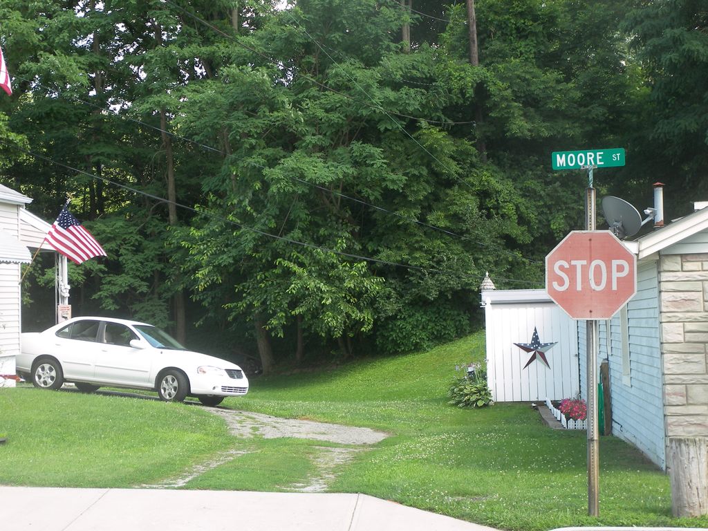
| Description | : | The cemetery is located south-southeast of the intersection of Moore Street and Steve Tanner Street (formerly Harris Street). The cemetery is behind the houses on the south side of Moore street past the tree line up a hill. The cemetery is listed as Gardner Cemetery on pages 33-34 of Small Kenton County, Kentucky, Cemeteries, published by the Kenton County Historical Society, Cemetery Committee, and on pages 33=34 of Kenton County Cemeteries, published by the Kenton County Historical Society, Covington, Kentucky, 1981. The cemetery inscriptions were recorded in October 1978, reporting 20 graves identifiable by inscription and many broken and... Read More |
frequently asked questions (FAQ):
-
Where is Gardner-Harris Cemetery?
Gardner-Harris Cemetery is located at Moore Street and Steve Tanner Street Bromley, Kenton County ,Kentucky , 41016USA.
-
Gardner-Harris Cemetery cemetery's updated grave count on graveviews.com?
4 memorials
-
Where are the coordinates of the Gardner-Harris Cemetery?
Latitude: 39.0807991
Longitude: -84.5586014
Nearby Cemetories:
1. Wilson Cemetery
Covington, Kenton County, USA
Coordinate: 39.0786110, -84.5438900
2. Montague Cemetery
Covington, Kenton County, USA
Coordinate: 39.0805560, -84.5380550
3. Flournoy Family Cemetery
Crescent Springs, Kenton County, USA
Coordinate: 39.0672830, -84.5706660
4. Reinhart Family Cemetery
Crescent Springs, Kenton County, USA
Coordinate: 39.0672510, -84.5707150
5. LaBare Cemetery
Crescent Springs, Kenton County, USA
Coordinate: 39.0631570, -84.5596300
6. Cleveland-McKay Family Cemetery
Villa Hills, Kenton County, USA
Coordinate: 39.0736230, -84.5802230
7. Saint John Cemetery
Fort Mitchell, Kenton County, USA
Coordinate: 39.0619011, -84.5550003
8. Saldridge Cemetery
Crescent Springs, Kenton County, USA
Coordinate: 39.0620860, -84.5690090
9. Saint Joseph Cemetery
Cincinnati, Hamilton County, USA
Coordinate: 39.1035995, -84.5757980
10. Sisters of Notre Dame Cemetery
Park Hills, Kenton County, USA
Coordinate: 39.0637530, -84.5303120
11. Saint Joseph Irish Cemetery
Price Hill, Hamilton County, USA
Coordinate: 39.1075050, -84.5740940
12. Craig Street Burying Ground
Covington, Kenton County, USA
Coordinate: 39.0840890, -84.5151330
13. Linden Grove Cemetery
Covington, Kenton County, USA
Coordinate: 39.0738983, -84.5152969
14. Lincoln Park Potters Field (Defunct)
Cincinnati, Hamilton County, USA
Coordinate: 39.1097710, -84.5346450
15. Highland Cemetery
Fort Mitchell, Kenton County, USA
Coordinate: 39.0475006, -84.5457993
16. Saint Walburg Cemetery
Villa Hills, Kenton County, USA
Coordinate: 39.0671860, -84.6001990
17. First Quaker Cemetery (Defunct)
Cincinnati, Hamilton County, USA
Coordinate: 39.1004360, -84.5201220
18. Mother of God Church
Covington, Kenton County, USA
Coordinate: 39.0839600, -84.5125700
19. Catherine Street Burying Ground
Cincinnati, Hamilton County, USA
Coordinate: 39.1067490, -84.5252700
20. Catherine Street Methodist Cemetery (Defunct)
Cincinnati, Hamilton County, USA
Coordinate: 39.1064840, -84.5243150
21. Enon Baptist Church Burying Ground (Defunct)
Cincinnati, Hamilton County, USA
Coordinate: 39.1065420, -84.5238110
22. Saint Mary's Cemetery
Fort Mitchell, Kenton County, USA
Coordinate: 39.0438995, -84.5500031
23. Trinity Episcopal Church Memorial Garden
Covington, Kenton County, USA
Coordinate: 39.0873540, -84.5106140
24. Mount Alverno Cemetery (Defunct)
Delhi, Hamilton County, USA
Coordinate: 39.0863890, -84.6083330