
| Memorials | : | 0 |
| Location | : | Gjøvik, Gjøvik kommune, Norway |
| Coordinate | : | 60.7880340, 10.6986880 |
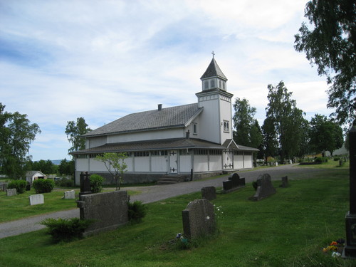
| Description | : | Gjøvik gravlund came into use in 1906, while the chapel was built in 1911. This is Gjøvik municipality's largest cemetery (it is 7 in total); It consists, among other things, of several urn gardens (urnelunder), and it has burial grounds for foreign religions and an urn garden for anonymous graves. The cemetery is beautifully situated by Lake Mjøsa - Norway's largest lake. NB! Gjøvik Church is located right in the center of the city, and has no cemetery attached to it. There are about 13,000 Soviet war graves in Norway. This includes Russians, Ukrainians, Kazakhstan and several other... Read More |
frequently asked questions (FAQ):
-
Where is Gjøvik gravlund?
Gjøvik gravlund is located at Østre Totenveg 16 Gjøvik, Gjøvik kommune ,Oppland fylke , 2816Norway.
-
Gjøvik gravlund cemetery's updated grave count on graveviews.com?
0 memorials
-
Where are the coordinates of the Gjøvik gravlund?
Latitude: 60.7880340
Longitude: 10.6986880
Nearby Cemetories:
1. Hunn gravlund
Gjøvik, Gjøvik kommune, Norway
Coordinate: 60.8019010, 10.6734890
2. Nordli Cemetery
Nordlia, Østre Toten kommune, Norway
Coordinate: 60.7432240, 10.7695170
3. Vardal kirkegård
Bybrua, Gjøvik kommune, Norway
Coordinate: 60.8161530, 10.5234840
4. Ringsaker kirkegård
Moelv, Ringsaker kommune, Norway
Coordinate: 60.9031110, 10.7242950
5. Aas Churchyard
Raufoss, Vestre Toten kommune, Norway
Coordinate: 60.6693210, 10.6990180
6. Nes kirkegård
Nes, Ringsaker kommune, Norway
Coordinate: 60.7625700, 10.9429500
7. Hoff Church Cemetery
Lena, Østre Toten kommune, Norway
Coordinate: 60.6847580, 10.8444930
8. Helgøya kirkegård
Nes, Ringsaker kommune, Norway
Coordinate: 60.7446645, 10.9585367
9. Seegård kirkegård
Snertingdal, Gjøvik kommune, Norway
Coordinate: 60.8803220, 10.4626220
10. Brumunddal kirkegård
Brumunddal, Ringsaker kommune, Norway
Coordinate: 60.8845300, 10.9528000
11. Veldre kirkegård
Veldre, Ringsaker kommune, Norway
Coordinate: 60.9172800, 10.8907600
12. Kolbu Kirke Churchyard
Østre Toten kommune, Norway
Coordinate: 60.6293210, 10.7737690
13. Furnes kirkegård
Furnes, Ringsaker kommune, Norway
Coordinate: 60.8406000, 11.0217000
14. Hol Cemetery
Hamar, Hamar kommune, Norway
Coordinate: 60.8154900, 11.0450600
15. Balke Kirkegaard
Skreia, Østre Toten kommune, Norway
Coordinate: 60.6681415, 10.9499695
16. Biri kirkegård
Biri, Gjøvik kommune, Norway
Coordinate: 60.9588990, 10.6018850
17. Hamar Kirkegaard
Hamar, Hamar kommune, Norway
Coordinate: 60.7991950, 11.0698420
18. Nykirke kirkegård
Snertingdal, Gjøvik kommune, Norway
Coordinate: 60.8977830, 10.3388270
19. Ottestad kirkegård
Ottestad, Stange kommune, Norway
Coordinate: 60.7573100, 11.1447300
20. Fluberg kirke
Fluberg, Søndre Land kommune, Norway
Coordinate: 60.7758230, 10.2467960
21. Åsmarka kirkegård
Åsmarka, Ringsaker kommune, Norway
Coordinate: 61.0117202, 10.7800753
22. Stange Church Cemetery
Stange, Stange kommune, Norway
Coordinate: 60.7098210, 11.1373780
23. Brøttum Cemetery
Brøttum, Ringsaker kommune, Norway
Coordinate: 61.0283660, 10.5496950
24. Øvre Vang kirkegård
Hamar, Hamar kommune, Norway
Coordinate: 60.8458900, 11.2043400