
| Memorials | : | 0 |
| Location | : | Veldre, Ringsaker kommune, Norway |
| Coordinate | : | 60.9172800, 10.8907600 |
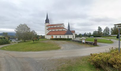
| Description | : | Veldre is correct but does not have its own postal code - the postaddress is 2385 Brumunddal. The church / cemetery is located at Byflaten, on a plateau above Brumunddal, and the road up there is steep and winding, slightly depending on which direction one comes from. There have been several churches in Veldre, but there is only one at Flisaker that is mentioned in writing – Flisaker church. It was first mentioned in 1332 and was in the courtyard east of the old “føderåds” building on Flisaker farm. This church eventually became... Read More |
frequently asked questions (FAQ):
-
Where is Veldre kirkegård?
Veldre kirkegård is located at Flesakervegen 23 Veldre, Ringsaker kommune ,Hedmark fylke ,Norway.
-
Veldre kirkegård cemetery's updated grave count on graveviews.com?
0 memorials
-
Where are the coordinates of the Veldre kirkegård?
Latitude: 60.9172800
Longitude: 10.8907600
Nearby Cemetories:
1. Brumunddal kirkegård
Brumunddal, Ringsaker kommune, Norway
Coordinate: 60.8845300, 10.9528000
2. Ringsaker kirkegård
Moelv, Ringsaker kommune, Norway
Coordinate: 60.9031110, 10.7242950
3. Furnes kirkegård
Furnes, Ringsaker kommune, Norway
Coordinate: 60.8406000, 11.0217000
4. Åsmarka kirkegård
Åsmarka, Ringsaker kommune, Norway
Coordinate: 61.0117202, 10.7800753
5. Hol Cemetery
Hamar, Hamar kommune, Norway
Coordinate: 60.8154900, 11.0450600
6. Biri kirkegård
Biri, Gjøvik kommune, Norway
Coordinate: 60.9588990, 10.6018850
7. Hamar Kirkegaard
Hamar, Hamar kommune, Norway
Coordinate: 60.7991950, 11.0698420
8. Hunn gravlund
Gjøvik, Gjøvik kommune, Norway
Coordinate: 60.8019010, 10.6734890
9. Nes kirkegård
Nes, Ringsaker kommune, Norway
Coordinate: 60.7625700, 10.9429500
10. Gjøvik gravlund
Gjøvik, Gjøvik kommune, Norway
Coordinate: 60.7880340, 10.6986880
11. Øvre Vang kirkegård
Hamar, Hamar kommune, Norway
Coordinate: 60.8458900, 11.2043400
12. Helgøya kirkegård
Nes, Ringsaker kommune, Norway
Coordinate: 60.7446645, 10.9585367
13. Nordli Cemetery
Nordlia, Østre Toten kommune, Norway
Coordinate: 60.7432240, 10.7695170
14. Brøttum Cemetery
Brøttum, Ringsaker kommune, Norway
Coordinate: 61.0283660, 10.5496950
15. Ottestad kirkegård
Ottestad, Stange kommune, Norway
Coordinate: 60.7573100, 11.1447300
16. Vardal kirkegård
Bybrua, Gjøvik kommune, Norway
Coordinate: 60.8161530, 10.5234840
17. Mesnali kirkegård
Mesnali, Ringsaker kommune, Norway
Coordinate: 61.1027820, 10.6929130
18. Seegård kirkegård
Snertingdal, Gjøvik kommune, Norway
Coordinate: 60.8803220, 10.4626220
19. Løten Kirke Cemetery
Loten, Løten kommune, Norway
Coordinate: 60.8268950, 11.3172070
20. Hoff Church Cemetery
Lena, Østre Toten kommune, Norway
Coordinate: 60.6847580, 10.8444930
21. Stange Church Cemetery
Stange, Stange kommune, Norway
Coordinate: 60.7098210, 11.1373780
22. Romedal Kirkegård
Romedal, Stange kommune, Norway
Coordinate: 60.7517000, 11.2614400
23. Balke Kirkegaard
Skreia, Østre Toten kommune, Norway
Coordinate: 60.6681415, 10.9499695
24. Aas Churchyard
Raufoss, Vestre Toten kommune, Norway
Coordinate: 60.6693210, 10.6990180