
| Memorials | : | 0 |
| Location | : | Bybrua, Gjøvik kommune, Norway |
| Coordinate | : | 60.8161530, 10.5234840 |
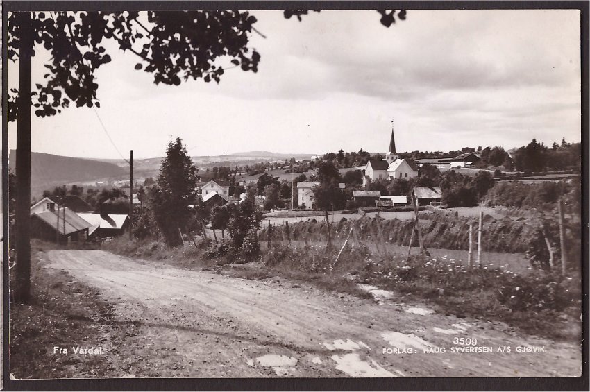
| Description | : | There has been a cemetery in Vardal as long as there has been church; there are also several old burial grounds in the areas around the existing cemetery. The present and third church was consecrated on November 30, 1803, while the first service was held on Sunday, September 18, the same year. The church / cemetery is built on Haug's farm; For that reason, the church, by the inhabitants of Vardal, is often called "Haugskjerka". The first church was a stave church - it is mentioned in documents from the 14th century. The second church was... Read More |
frequently asked questions (FAQ):
-
Where is Vardal kirkegård?
Vardal kirkegård is located at Vardalsvegen 757 Bybrua, Gjøvik kommune ,Oppland fylke , 2822Norway.
-
Vardal kirkegård cemetery's updated grave count on graveviews.com?
0 memorials
-
Where are the coordinates of the Vardal kirkegård?
Latitude: 60.8161530
Longitude: 10.5234840
Nearby Cemetories:
1. Seegård kirkegård
Snertingdal, Gjøvik kommune, Norway
Coordinate: 60.8803220, 10.4626220
2. Hunn gravlund
Gjøvik, Gjøvik kommune, Norway
Coordinate: 60.8019010, 10.6734890
3. Gjøvik gravlund
Gjøvik, Gjøvik kommune, Norway
Coordinate: 60.7880340, 10.6986880
4. Nykirke kirkegård
Snertingdal, Gjøvik kommune, Norway
Coordinate: 60.8977830, 10.3388270
5. Ringsaker kirkegård
Moelv, Ringsaker kommune, Norway
Coordinate: 60.9031110, 10.7242950
6. Nordli Cemetery
Nordlia, Østre Toten kommune, Norway
Coordinate: 60.7432240, 10.7695170
7. Fluberg kirke
Fluberg, Søndre Land kommune, Norway
Coordinate: 60.7758230, 10.2467960
8. Biri kirkegård
Biri, Gjøvik kommune, Norway
Coordinate: 60.9588990, 10.6018850
9. Aas Churchyard
Raufoss, Vestre Toten kommune, Norway
Coordinate: 60.6693210, 10.6990180
10. Hoff Church Cemetery
Lena, Østre Toten kommune, Norway
Coordinate: 60.6847580, 10.8444930
11. Veldre kirkegård
Veldre, Ringsaker kommune, Norway
Coordinate: 60.9172800, 10.8907600
12. Nes kirkegård
Nes, Ringsaker kommune, Norway
Coordinate: 60.7625700, 10.9429500
13. Brøttum Cemetery
Brøttum, Ringsaker kommune, Norway
Coordinate: 61.0283660, 10.5496950
14. Ostsinni Church Cemetery
Dokka, Nordre Land kommune, Norway
Coordinate: 60.8490580, 10.0783310
15. Brumunddal kirkegård
Brumunddal, Ringsaker kommune, Norway
Coordinate: 60.8845300, 10.9528000
16. Kolbu Kirke Churchyard
Østre Toten kommune, Norway
Coordinate: 60.6293210, 10.7737690
17. Helgøya kirkegård
Nes, Ringsaker kommune, Norway
Coordinate: 60.7446645, 10.9585367
18. Åsmarka kirkegård
Åsmarka, Ringsaker kommune, Norway
Coordinate: 61.0117202, 10.7800753
19. Furnes kirkegård
Furnes, Ringsaker kommune, Norway
Coordinate: 60.8406000, 11.0217000
20. Enger kirkegård
Enger, Søndre Land kommune, Norway
Coordinate: 60.5801000, 10.3338000
21. Hol Cemetery
Hamar, Hamar kommune, Norway
Coordinate: 60.8154900, 11.0450600
22. Balke Kirkegaard
Skreia, Østre Toten kommune, Norway
Coordinate: 60.6681415, 10.9499695
23. Vingrom kirkegård
Lillehammer, Lillehammer kommune, Norway
Coordinate: 61.0722800, 10.4298900
24. Hamar Kirkegaard
Hamar, Hamar kommune, Norway
Coordinate: 60.7991950, 11.0698420