
| Memorials | : | 82 |
| Location | : | Goodnestone, Dover District, England |
| Coordinate | : | 51.2457190, 1.2290550 |
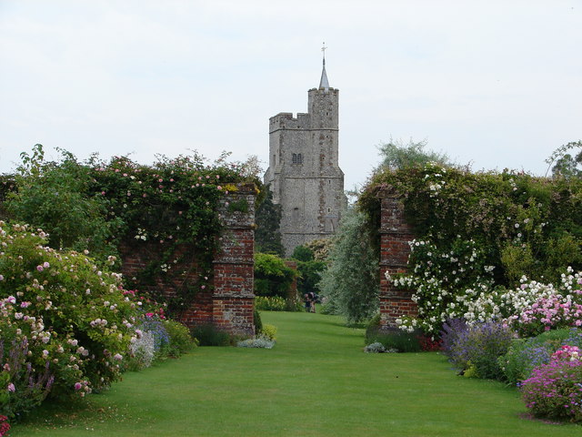
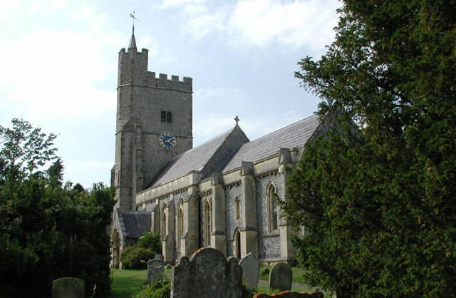
| Description | : | The Church is located off the A257 Canterbury to Sandwich Road, 3 miles South of Wingham on the way to Goodnestone Park and is next to the Fitz Walter Arms Pub This Grade 1 listed Parish Church is built of knapped flint and Caen stone dating back in part from the 12th Century with a 13th Century extension and rebuilt tower from the 15th Century which has a clock and five bells. The Nave and Chancel were rebuilt in 1838-41 in the 13th Century style Nearby Goodnestone Park was built by Sir Brook Bridges, 1st Baronet, whose family were related by marriage... Read More |
frequently asked questions (FAQ):
-
Where is Holy Cross?
Holy Cross is located at The Street Goodnestone, Dover District ,Kent ,England.
-
Holy Cross cemetery's updated grave count on graveviews.com?
82 memorials
-
Where are the coordinates of the Holy Cross?
Latitude: 51.2457190
Longitude: 1.2290550
Nearby Cemetories:
1. St Mary the Virgin Churchyard
Nonington, Dover District, England
Coordinate: 51.2258300, 1.2253800
2. St James the Great Churchyard
Staple, Dover District, England
Coordinate: 51.2636300, 1.2515200
3. Holy Innocents Churchyard
Adisham, City of Canterbury, England
Coordinate: 51.2440380, 1.1903320
4. St Clement Church
Knowlton, Dover District, England
Coordinate: 51.2348930, 1.2652130
5. St Mary the Virgin Churchyard
Wingham, Dover District, England
Coordinate: 51.2721220, 1.2128950
6. St Nicholas’ Barfrestone Church Burial Ground
Eythorne, Dover District, England
Coordinate: 51.2056350, 1.2400870
7. Saint Nicholas Churchyard
Eythorne, Dover District, England
Coordinate: 51.2055720, 1.2400490
8. St Margaret of Antioch Churchyard
Womenswold, City of Canterbury, England
Coordinate: 51.2109850, 1.1878090
9. St. Nicholas Churchyard
Ash, Dover District, England
Coordinate: 51.2786800, 1.2786400
10. Aylesham Cemetery
Aylesham, Dover District, England
Coordinate: 51.2126910, 1.1781980
11. St Andrew Churchyard
Wickhambreaux, City of Canterbury, England
Coordinate: 51.2844400, 1.1822300
12. Saint Peter & Saint Paul Churchyard
Eythorne, Dover District, England
Coordinate: 51.2011990, 1.2616710
13. St Mary the Virgin Churchyard
Eastry, Dover District, England
Coordinate: 51.2453000, 1.3100000
14. Saint Andrew Churchyard
Tilmanstone, Dover District, England
Coordinate: 51.2159790, 1.2950400
15. Elmstone Churchyard
Preston, Dover District, England
Coordinate: 51.2967160, 1.2424980
16. Saint Mary The Virgin Churchyard
Woodnesborough, Dover District, England
Coordinate: 51.2628240, 1.3073810
17. Eythorne Baptist Church Cemetery
Eythorne, Dover District, England
Coordinate: 51.1982330, 1.2661470
18. St Mildred Churchyard
Preston, Dover District, England
Coordinate: 51.2985000, 1.2173980
19. St Peter Churchyard
Bekesbourne, City of Canterbury, England
Coordinate: 51.2563430, 1.1445750
20. St Mary the Virgin Churchyard
Betteshanger, Dover District, England
Coordinate: 51.2251200, 1.3118800
21. Barham Crematorium
Barham, City of Canterbury, England
Coordinate: 51.1972610, 1.1800310
22. St John the Baptist Churchyard
Barham, City of Canterbury, England
Coordinate: 51.2065410, 1.1620830
23. St John the Baptist Church Cemetery
Barham, City of Canterbury, England
Coordinate: 51.2056600, 1.1629900
24. St Mary Churchyard
Patrixbourne, City of Canterbury, England
Coordinate: 51.2534430, 1.1364840