
| Memorials | : | 0 |
| Location | : | Preston, Dover District, England |
| Coordinate | : | 51.2985000, 1.2173980 |
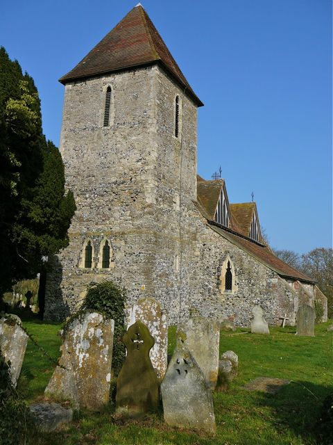
| Description | : | Although the Victorian tiled roof of its square tower can be seen across the fields for a considerable distance, St Mildred's Church is not easy to find, being hidden at the end of a rural cul-de-sac some distance from the village. The church is Early English in style, with an unusual feature of four large diamond-leaded dormer windows. The churchyard is shaded by trees on two sides, and open to the fields on the others. Juliana Leybourne, Countess of Huntingdon (1303/4–1367) known as 'The Infanta of Kent' because of her extensive property in the county, had her palace on the... Read More |
frequently asked questions (FAQ):
-
Where is St Mildred Churchyard?
St Mildred Churchyard is located at Court Lane, Preston-next-Wingham Preston, Dover District ,Kent , CT3 1DJEngland.
-
St Mildred Churchyard cemetery's updated grave count on graveviews.com?
0 memorials
-
Where are the coordinates of the St Mildred Churchyard?
Latitude: 51.2985000
Longitude: 1.2173980
Nearby Cemetories:
1. Elmstone Churchyard
Preston, Dover District, England
Coordinate: 51.2967160, 1.2424980
2. Stodmarsh St Marys Churchyard
Wickhambreaux, City of Canterbury, England
Coordinate: 51.3009500, 1.1836900
3. All Saints Churchyard
Stourmouth, Dover District, England
Coordinate: 51.3202600, 1.2365520
4. St Andrew Churchyard
Wickhambreaux, City of Canterbury, England
Coordinate: 51.2844400, 1.1822300
5. St Mary the Virgin Churchyard
Wingham, Dover District, England
Coordinate: 51.2721220, 1.2128950
6. St Mary The Virgin Churchyard
Chislet, City of Canterbury, England
Coordinate: 51.3343610, 1.1921020
7. St James the Great Churchyard
Staple, Dover District, England
Coordinate: 51.2636300, 1.2515200
8. St. Nicholas Churchyard
Ash, Dover District, England
Coordinate: 51.2786800, 1.2786400
9. All Saints Churchyard
Westbere, City of Canterbury, England
Coordinate: 51.3065380, 1.1437670
10. Holy Cross
Goodnestone, Dover District, England
Coordinate: 51.2457190, 1.2290550
11. Sturry Cemetery
Sturry, City of Canterbury, England
Coordinate: 51.3058100, 1.1277700
12. St Mary the Virgin Churchyard
Fordwich, City of Canterbury, England
Coordinate: 51.2958300, 1.1270530
13. Holy Innocents Churchyard
Adisham, City of Canterbury, England
Coordinate: 51.2440380, 1.1903320
14. St. Nicholas' Churchyard
St Nicholas at Wade, Thanet District, England
Coordinate: 51.3542160, 1.2517980
15. St Nicholas Churchyard
Sturry, City of Canterbury, England
Coordinate: 51.2984830, 1.1201330
16. St Peter Churchyard
Bekesbourne, City of Canterbury, England
Coordinate: 51.2563430, 1.1445750
17. St Nicholas-at-Wade Cemetery
St Nicholas at Wade, Thanet District, England
Coordinate: 51.3578344, 1.2534168
18. Saint Mary The Virgin Churchyard
Woodnesborough, Dover District, England
Coordinate: 51.2628240, 1.3073810
19. St Mary Churchyard
Patrixbourne, City of Canterbury, England
Coordinate: 51.2534430, 1.1364840
20. St Mary the Virgin Church
Minster-in-Thanet, Thanet District, England
Coordinate: 51.3305810, 1.3156720
21. St Clement Church
Knowlton, Dover District, England
Coordinate: 51.2348930, 1.2652130
22. St Mary the Virgin Churchyard
Nonington, Dover District, England
Coordinate: 51.2258300, 1.2253800
23. St Martin's Churchyard
Herne, City of Canterbury, England
Coordinate: 51.3497060, 1.1334370
24. St Martins
Herne, City of Canterbury, England
Coordinate: 51.3500600, 1.1333200