
| Memorials | : | 32 |
| Location | : | Staple, Dover District, England |
| Coordinate | : | 51.2636300, 1.2515200 |
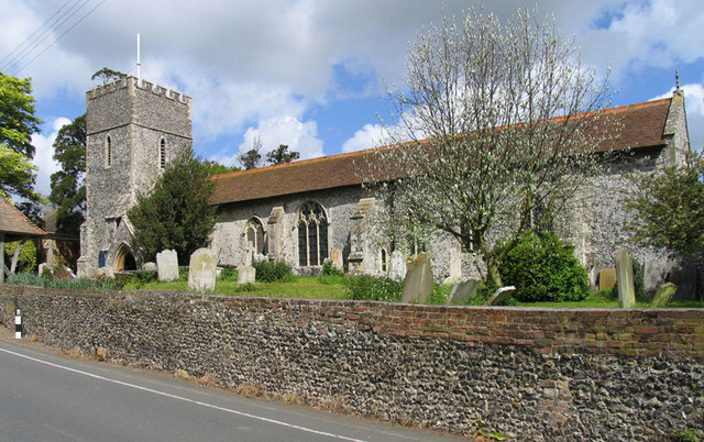
| Description | : | Staple's church is dedicated to St. James The Great, Apostle and Martyr, and patron saint of all travelers and pilgrims. The church is mainly 14th & 15th Century, with a tower and East window of 13th Century origin. The Church has a fine lychgate which bears the date 1664. The clock is one-handed, showing the hours only. It was given to the church in 1789 by Lady Lynch of Groves. The clock was second-hand, having been used elsewhere, and was made long before 1789. The bell tower houses four bells (one of the oldest bells in Kent,... Read More |
frequently asked questions (FAQ):
-
Where is St James the Great Churchyard?
St James the Great Churchyard is located at The Street Staple, Dover District ,Kent , CT3 1LNEngland.
-
St James the Great Churchyard cemetery's updated grave count on graveviews.com?
32 memorials
-
Where are the coordinates of the St James the Great Churchyard?
Latitude: 51.2636300
Longitude: 1.2515200
Nearby Cemetories:
1. St. Nicholas Churchyard
Ash, Dover District, England
Coordinate: 51.2786800, 1.2786400
2. Holy Cross
Goodnestone, Dover District, England
Coordinate: 51.2457190, 1.2290550
3. St Mary the Virgin Churchyard
Wingham, Dover District, England
Coordinate: 51.2721220, 1.2128950
4. St Clement Church
Knowlton, Dover District, England
Coordinate: 51.2348930, 1.2652130
5. Elmstone Churchyard
Preston, Dover District, England
Coordinate: 51.2967160, 1.2424980
6. Saint Mary The Virgin Churchyard
Woodnesborough, Dover District, England
Coordinate: 51.2628240, 1.3073810
7. St Mildred Churchyard
Preston, Dover District, England
Coordinate: 51.2985000, 1.2173980
8. St Mary the Virgin Churchyard
Eastry, Dover District, England
Coordinate: 51.2453000, 1.3100000
9. St Mary the Virgin Churchyard
Nonington, Dover District, England
Coordinate: 51.2258300, 1.2253800
10. Holy Innocents Churchyard
Adisham, City of Canterbury, England
Coordinate: 51.2440380, 1.1903320
11. St Andrew Churchyard
Wickhambreaux, City of Canterbury, England
Coordinate: 51.2844400, 1.1822300
12. Church of Saint George at Ham
Eastry, Dover District, England
Coordinate: 51.2444830, 1.3319350
13. St Mary the Virgin Churchyard
Betteshanger, Dover District, England
Coordinate: 51.2251200, 1.3118800
14. Saint Andrew Churchyard
Tilmanstone, Dover District, England
Coordinate: 51.2159790, 1.2950400
15. St .Mary's Churchyard
Sandwich, Dover District, England
Coordinate: 51.2771930, 1.3386580
16. Stodmarsh St Marys Churchyard
Wickhambreaux, City of Canterbury, England
Coordinate: 51.3009500, 1.1836900
17. St. Peter's Churchyard
Sandwich, Dover District, England
Coordinate: 51.2747680, 1.3405120
18. All Saints Churchyard
Stourmouth, Dover District, England
Coordinate: 51.3202600, 1.2365520
19. St Clement's Church
Sandwich, Dover District, England
Coordinate: 51.2736510, 1.3427270
20. St Nicholas’ Barfrestone Church Burial Ground
Eythorne, Dover District, England
Coordinate: 51.2056350, 1.2400870
21. Saint Nicholas Churchyard
Eythorne, Dover District, England
Coordinate: 51.2055720, 1.2400490
22. Saint Peter & Saint Paul Churchyard
Eythorne, Dover District, England
Coordinate: 51.2011990, 1.2616710
23. Eythorne Baptist Church Cemetery
Eythorne, Dover District, England
Coordinate: 51.1982330, 1.2661470
24. St Margaret of Antioch Churchyard
Womenswold, City of Canterbury, England
Coordinate: 51.2109850, 1.1878090