
| Memorials | : | 14 |
| Location | : | Hardin, Ray County, USA |
| Coordinate | : | 39.3078003, -93.8394012 |
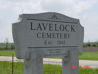
| Description | : | Located 1 mile west of Hardin on Hwy 10; 2 miles north on "A." You need to go through two cattle gates to get to the cemetery. There is a large sign at the entrance on the east side of Route A but the cemetery is loacted a distance from the road. History: In 1845 John W. Morris and wife deeded three acres for this cemetery. There were several conditions to this deed - the ground must be used for a place of worship, a public burying ground and a school be erected if advisable in the future.... Read More |
frequently asked questions (FAQ):
-
Where is Lavelock Cemetery?
Lavelock Cemetery is located at Hardin, Ray County ,Missouri ,USA.
-
Lavelock Cemetery cemetery's updated grave count on graveviews.com?
10 memorials
-
Where are the coordinates of the Lavelock Cemetery?
Latitude: 39.3078003
Longitude: -93.8394012
Nearby Cemetories:
1. Forester Cemetery
Hardin, Ray County, USA
Coordinate: 39.3125700, -93.8079100
2. Bohannon Cemetery
Hardin, Ray County, USA
Coordinate: 39.3291600, -93.8580600
3. Wakenda Cemetery
Hardin, Ray County, USA
Coordinate: 39.3519300, -93.8456900
4. Pugh Cemetery
Richmond, Ray County, USA
Coordinate: 39.3124800, -93.8968700
5. Hardin Cemetery
Hardin, Ray County, USA
Coordinate: 39.2661018, -93.8181000
6. Hickory Grove Cemetery
Richmond, Ray County, USA
Coordinate: 39.3288120, -93.9006293
7. Clark Cemetery
Hardin, Ray County, USA
Coordinate: 39.3499985, -93.7956009
8. Meinking-Wilson Cemetery
Ray County, USA
Coordinate: 39.3576200, -93.7995600
9. Liberty Cemetery
Hardin, Ray County, USA
Coordinate: 39.3331800, -93.7667800
10. Boggess Cemetery
Hardin, Ray County, USA
Coordinate: 39.2447200, -93.8205600
11. Woolard Cemetery
Hardin, Ray County, USA
Coordinate: 39.3769300, -93.8351500
12. McGaugh-Dickey Cemetery
Richmond, Ray County, USA
Coordinate: 39.2742800, -93.9229200
13. Nutter Cemetery
Richmond, Ray County, USA
Coordinate: 39.2966995, -93.9344025
14. Hill Cemetery
Richmond, Ray County, USA
Coordinate: 39.2933006, -93.9419022
15. Ray County Poor Farm Cemetery
Richmond, Ray County, USA
Coordinate: 39.3377110, -93.9391770
16. Lile Cemetery
Richmond, Ray County, USA
Coordinate: 39.2881700, -93.9477800
17. Berry Cemetery
Hardin, Ray County, USA
Coordinate: 39.3913800, -93.8710800
18. Oliphant Cemetery
Richmond, Ray County, USA
Coordinate: 39.3573300, -93.9362200
19. Gunnell Cemetery
Richmond, Ray County, USA
Coordinate: 39.3072014, -93.9569016
20. Richmond Memory Gardens
Richmond, Ray County, USA
Coordinate: 39.2771988, -93.9518967
21. Murray-Anderson Cemetery
Richmond, Ray County, USA
Coordinate: 39.2631400, -93.9447100
22. Watkins Cemetery
Richmond, Ray County, USA
Coordinate: 39.2633018, -93.9449997
23. Johnson Cemetery
Richmond, Ray County, USA
Coordinate: 39.3157997, -93.9630966
24. Carleton Cemetery
Ray County, USA
Coordinate: 39.4014200, -93.8712700