
| Memorials | : | 0 |
| Location | : | Starnberg, Landkreis Starnberg, Germany |
| Coordinate | : | 48.0026436, 11.3202034 |
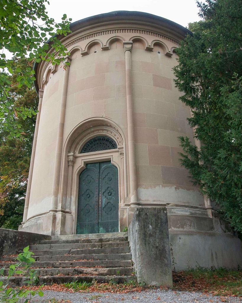
| Description | : | AKA Mausoleum des Prinzen Karl von Bayern Prince Carl of Bavaria (Karl von Bayern) had this mausoleum built from 1838 to 1840 for his beloved wife Marie Anne Sophie Petin. Designed by architect Joseph Daniel Ohlmüller. The prince lost his right to the Bavarian throne, when he married Marie in 1823, as she was considered a "commoner". His tomb and the ones for his two wives are located inside the mausoleum. Also, part of the park is a "Säulenhalle", which is the resting place for a few members of the Counts of Almeida. Just up the hill is the Friedhof Söcking and... Read More |
frequently asked questions (FAQ):
-
Where is Mausoleum Söcking?
Mausoleum Söcking is located at Andechser Strasse 29 Starnberg, Landkreis Starnberg ,Bavaria (Bayern) , 82319Germany.
-
Mausoleum Söcking cemetery's updated grave count on graveviews.com?
0 memorials
-
Where are the coordinates of the Mausoleum Söcking?
Latitude: 48.0026436
Longitude: 11.3202034
Nearby Cemetories:
1. Friedhof Söcking
Starnberg, Landkreis Starnberg, Germany
Coordinate: 48.0042229, 11.3223982
2. Starnberg-St. Josefs Kirche
Starnberg, Landkreis Starnberg, Germany
Coordinate: 47.9977130, 11.3382250
3. Friedhof Hanfelderstrasse
Starnberg, Landkreis Starnberg, Germany
Coordinate: 48.0041100, 11.3400000
4. Starnberg-Waldfriedhof
Starnberg, Landkreis Starnberg, Germany
Coordinate: 48.0146800, 11.3453700
5. St. Bartholomäus Kirchhof Maising
Maising, Landkreis Starnberg, Germany
Coordinate: 47.9861107, 11.2893600
6. Friedhof Gut Rieden. Starnberg
Starnberg, Landkreis Starnberg, Germany
Coordinate: 48.0248642, 11.3478146
7. Sankt Valentin Dorfkirche
Starnberg, Landkreis Starnberg, Germany
Coordinate: 47.9987640, 11.3646330
8. Friedhof Perchting
Starnberg, Landkreis Starnberg, Germany
Coordinate: 48.0003777, 11.2748775
9. Gemeindefriedhof Starnberg - Percha
Starnberg, Landkreis Starnberg, Germany
Coordinate: 48.0004616, 11.3668032
10. Alter Friedhof Pöcking
Pocking, Landkreis Starnberg, Germany
Coordinate: 47.9673424, 11.3019686
11. Neuer Friedhof Pöcking
Pocking, Landkreis Starnberg, Germany
Coordinate: 47.9680099, 11.2987900
12. Friedhof Leutstetten
Starnberg, Landkreis Starnberg, Germany
Coordinate: 48.0291634, 11.3668804
13. St. Alto Kirchhof
Starnberg, Landkreis Starnberg, Germany
Coordinate: 48.0291040, 11.3669780
14. Friedhof Hausen an der Dreifaltigkeitskriche
Gauting, Landkreis Starnberg, Germany
Coordinate: 48.0432190, 11.3306130
15. Friedhof Oberbrunn
Gauting, Landkreis Starnberg, Germany
Coordinate: 48.0502420, 11.3159280
16. Friedhof Feldafing
Feldafing, Landkreis Starnberg, Germany
Coordinate: 47.9526900, 11.2943300
17. Jüdischer Friedhof Feldafing
Feldafing, Landkreis Starnberg, Germany
Coordinate: 47.9525620, 11.2938840
18. Friedhof Aufkirchen
Berg am See, Landkreis Starnberg, Germany
Coordinate: 47.9570190, 11.3611760
19. Friedhof Aschering
Pocking, Landkreis Starnberg, Germany
Coordinate: 47.9659958, 11.2569561
20. Starnberg - Friedhof Wangen St. Ulrich
Wangen, Landkreis Starnberg, Germany
Coordinate: 48.0113419, 11.4031405
21. Friedhof Unterbrunn
Gauting, Landkreis Starnberg, Germany
Coordinate: 48.0657200, 11.3220630
22. Kirchenfriedhof Traubing
Tutzing, Landkreis Starnberg, Germany
Coordinate: 47.9440918, 11.2582502
23. Traubing New Cemetery
Tutzing, Landkreis Starnberg, Germany
Coordinate: 47.9450531, 11.2541561
24. Marienkirche Gauting
Gauting, Landkreis Starnberg, Germany
Coordinate: 48.0680700, 11.3787900