
| Memorials | : | 2 |
| Location | : | Coal County, USA |
| Coordinate | : | 34.6542015, -96.1849976 |
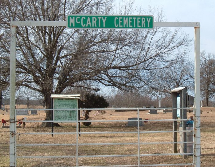
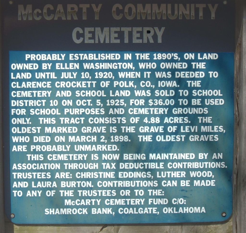
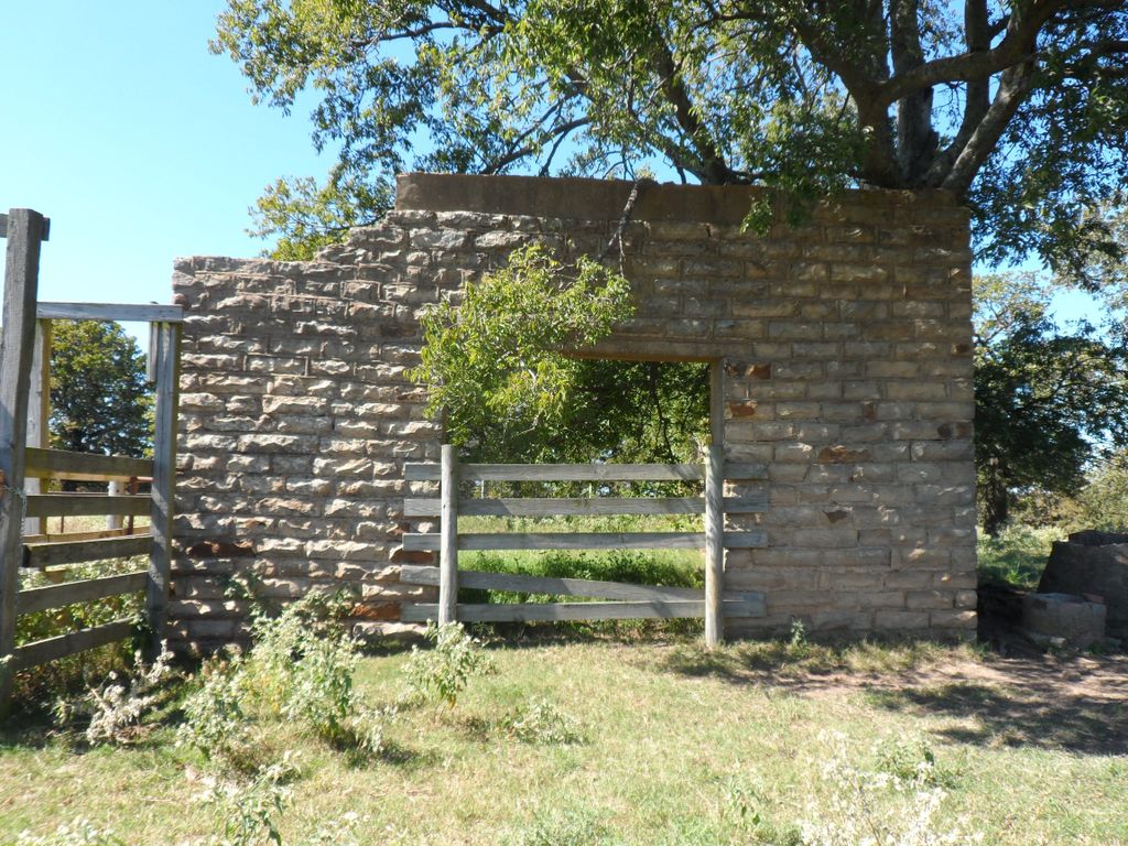
| Description | : | The cemetery is inside a fence near the old remains of McCarty School. The first burials in this cemetery were sometime in the 1890's, on land owned by Ellen Washington. On July 10, 1920, she deeded the land to Clarence Crockett of Polk County, Iowa. On October 5, 1925, the cemetery and school land was sold to School District No. 10 for $36.00, with the stipulation that the land could only be used for school purposes and cemetery grounds. The tract consists of 4.88 acres. The very oldest graves are probably unmarked, but the oldest marked grave is that of... Read More |
frequently asked questions (FAQ):
-
Where is McCarty Cemetery?
McCarty Cemetery is located at Coal County ,Oklahoma ,USA.
-
McCarty Cemetery cemetery's updated grave count on graveviews.com?
2 memorials
-
Where are the coordinates of the McCarty Cemetery?
Latitude: 34.6542015
Longitude: -96.1849976
Nearby Cemetories:
1. Ott Cemetery
Coal County, USA
Coordinate: 34.6244011, -96.1931000
2. Lone Star Cemetery
Coal County, USA
Coordinate: 34.6660995, -96.0914001
3. Pine Cemetery
Coal County, USA
Coordinate: 34.7263985, -96.2375031
4. Cairo Cemetery
Cairo, Coal County, USA
Coordinate: 34.5881004, -96.1082993
5. Coalgate Cemetery
Coalgate, Coal County, USA
Coordinate: 34.5628014, -96.2155991
6. King Cemetery
Coal County, USA
Coordinate: 34.7341995, -96.1128006
7. Woodman Cemetery
Coalgate, Coal County, USA
Coordinate: 34.5341988, -96.1996994
8. Wardville Cemetery
Wardville, Atoka County, USA
Coordinate: 34.6585780, -96.0364260
9. Globe Cemetery
Coal County, USA
Coordinate: 34.6921997, -96.3272018
10. Centrahoma Cemetery
Centrahoma, Coal County, USA
Coordinate: 34.6061707, -96.3365326
11. Bethel Cemetery
Atoka County, USA
Coordinate: 34.6070360, -96.0262340
12. Non Cemetery
Non, Hughes County, USA
Coordinate: 34.7835999, -96.2469025
13. Calvary Cemetery
Phillips, Coal County, USA
Coordinate: 34.5121994, -96.2136002
14. Round Lake Cemetery
Centrahoma, Coal County, USA
Coordinate: 34.5778008, -96.3371964
15. Kelly Cemetery
Wardville, Atoka County, USA
Coordinate: 34.6385994, -96.0066986
16. Ashland Cemetery
Ashland, Pittsburg County, USA
Coordinate: 34.7669440, -96.0655556
17. Bohannon Cemetery
Hughes County, USA
Coordinate: 34.7969444, -96.1144444
18. Boiling Springs Cemetery
Coal County, USA
Coordinate: 34.7225150, -96.3553670
19. Panther Creek Cemetery
Gerty, Hughes County, USA
Coordinate: 34.7672005, -96.3174973
20. Nixon Cemetery
Coalgate, Coal County, USA
Coordinate: 34.5345150, -96.3253070
21. Harpers Valley Cemetery
Kiowa, Pittsburg County, USA
Coordinate: 34.7172222, -95.9919444
22. Lehigh Cemetery
Lehigh, Coal County, USA
Coordinate: 34.4775900, -96.2319400
23. Limestone Gap Cemetery
Atoka County, USA
Coordinate: 34.6144180, -95.9702300
24. Boggy Bend Cemetery
Stringtown, Atoka County, USA
Coordinate: 34.4955556, -96.0775000