
| Memorials | : | 80 |
| Location | : | Borough Green, Tonbridge and Malling Borough, England |
| Website | : | omf.org/uk/ |
| Coordinate | : | 51.2937286, 0.3066902 |
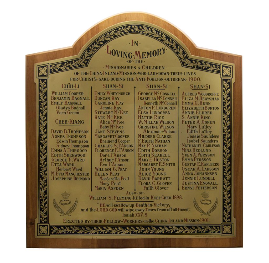
| Description | : | Memorial plaques of missionaries martyred in the Boxer Rebellion and on other occasions are displayed at this site. With only unmarked graves in China, these cenotaphs serve as the only memorial of their sacrifice. Regarding the feelings of the missionaries towards their aggressors, one survivor wrote, “Thank God, we bear them no malice, and can truly say, ‘Father, forgive them, for they know not what they do.’” Supporting information and photographs come from the book Martyred Missionaries of the China Inland Mission: with a record of the perils and sufferings of some who escaped edited by Marshall Broomhall, B.A. and published... Read More |
frequently asked questions (FAQ):
-
Where is OMF International UK?
OMF International UK is located at Unit 6; Station Approach Borough Green, Tonbridge and Malling Borough ,Kent , TN15 8BGEngland.
-
OMF International UK cemetery's updated grave count on graveviews.com?
80 memorials
-
Where are the coordinates of the OMF International UK?
Latitude: 51.2937286
Longitude: 0.3066902
Nearby Cemetories:
1. Borough Green Baptist Churchyard
Borough Green, Tonbridge and Malling Borough, England
Coordinate: 51.2916540, 0.3053750
2. Church of the Good Shepherd
Borough Green, Tonbridge and Malling Borough, England
Coordinate: 51.2910300, 0.3037660
3. St Mary the Virgin Churchyard
Platt, Tonbridge and Malling Borough, England
Coordinate: 51.2892070, 0.3252260
4. St Peter Churchyard
Ightham, Tonbridge and Malling Borough, England
Coordinate: 51.2891680, 0.2858450
5. St George Churchyard
Wrotham, Tonbridge and Malling Borough, England
Coordinate: 51.3088360, 0.3110130
6. Wrotham Cemetery
Wrotham, Tonbridge and Malling Borough, England
Coordinate: 51.3099430, 0.3108890
7. Plaxtol Parish Churchyard
Plaxtol, Tonbridge and Malling Borough, England
Coordinate: 51.2593498, 0.2945710
8. Plaxtol War Memorial
Plaxtol, Tonbridge and Malling Borough, England
Coordinate: 51.2592888, 0.2948450
9. St. Lawrence Churchyard
Seal Chart, Sevenoaks District, England
Coordinate: 51.2742910, 0.2537250
10. St Mary the Virgin Churchyard
Stansted, Tonbridge and Malling Borough, England
Coordinate: 51.3355120, 0.3060170
11. Ightham Mote
Ightham, Tonbridge and Malling Borough, England
Coordinate: 51.2584610, 0.2695830
12. St Peter and St Paul Churchyard
Trottiscliffe, Tonbridge and Malling Borough, England
Coordinate: 51.3201520, 0.3612360
13. St Michael Churchyard
Offham, Tonbridge and Malling Borough, England
Coordinate: 51.2974968, 0.3801070
14. St Mary the Virgin Churchyard
Kemsing, Sevenoaks District, England
Coordinate: 51.3068670, 0.2310220
15. St Mary's Churchyard Woodlands
West Kingsdown, Sevenoaks District, England
Coordinate: 51.3233700, 0.2428600
16. St Giles Churchyard
Shipbourne, Tonbridge and Malling Borough, England
Coordinate: 51.2471700, 0.2786090
17. St Peter and St Paul Churchyard
Seal, Sevenoaks District, England
Coordinate: 51.2907080, 0.2223010
18. St Dunstan Churchyard
West Peckham, Tonbridge and Malling Borough, England
Coordinate: 51.2486191, 0.3544910
19. St Lawrence Churchyard
Mereworth, Tonbridge and Malling Borough, England
Coordinate: 51.2587620, 0.3778260
20. St. Mary the Virgin Churchyard
West Malling, Tonbridge and Malling Borough, England
Coordinate: 51.2921700, 0.4068400
21. St Peter and St Paul Churchyard
Ash, Sevenoaks District, England
Coordinate: 51.3575990, 0.2989910
22. Greatness Park Cemetery
Sevenoaks, Sevenoaks District, England
Coordinate: 51.2906800, 0.2043260
23. St. Michael's Churchyard
East Peckham, Tonbridge and Malling Borough, England
Coordinate: 51.2442703, 0.3791970
24. St. Margaret's Churchyard
Underriver, Sevenoaks District, England
Coordinate: 51.2458191, 0.2291520