
| Memorials | : | 0 |
| Location | : | Bourbon Township, Boone County, USA |
| Coordinate | : | 39.1880989, -92.2833023 |
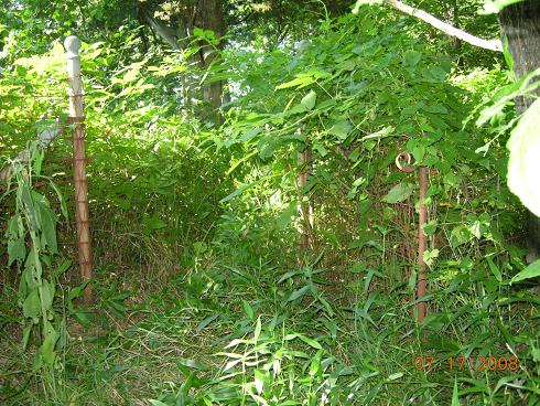
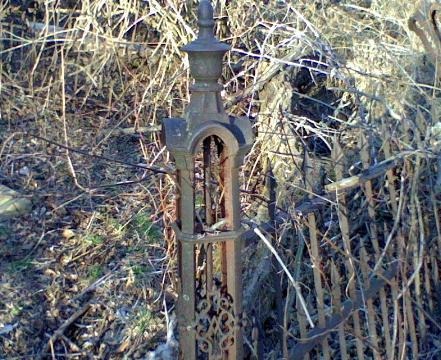
| Description | : | SW 1/4 Sec. 20, Town. 51, Range 12, Bourbon Township, Boone County, Missouri. This cemetery is located in a valley of a wheat field atop a little hill under the trees. It has not been kept up and cattle have run here so the stones have been trampled. |
frequently asked questions (FAQ):
-
Where is Palmer Cemetery?
Palmer Cemetery is located at Bourbon Township, Boone County ,Missouri ,USA.
-
Palmer Cemetery cemetery's updated grave count on graveviews.com?
0 memorials
-
Where are the coordinates of the Palmer Cemetery?
Latitude: 39.1880989
Longitude: -92.2833023
Nearby Cemetories:
1. Ruth Nowell Burial
Sturgeon, Boone County, USA
Coordinate: 39.1734026, -92.2921461
2. Palmer Family Cemetery
Sturgeon, Boone County, USA
Coordinate: 39.1666718, -92.2712555
3. Mount Horeb Cemetery
Sturgeon, Boone County, USA
Coordinate: 39.2158012, -92.2842026
4. Locust Grove Church Cemetery
Boone County, USA
Coordinate: 39.1702461, -92.3188477
5. Brink-Gibson Cemetery
Sturgeon, Boone County, USA
Coordinate: 39.2195540, -92.2956280
6. Locust Grove Baptist Church Cemetery
Sturgeon, Boone County, USA
Coordinate: 39.1698300, -92.3185900
7. Far West Cemetery
Sturgeon, Boone County, USA
Coordinate: 39.1986008, -92.2388992
8. Sturgeon Cemetery
Sturgeon, Boone County, USA
Coordinate: 39.2331009, -92.2936020
9. Naylor Cemetery
Riggs, Boone County, USA
Coordinate: 39.1589012, -92.3368988
10. Union Cumberland Presbyterian Church Cemetery
Riggs, Boone County, USA
Coordinate: 39.1716309, -92.3455200
11. Fountain Cemetery
Boone County, USA
Coordinate: 39.1963997, -92.2118988
12. Lick Fork Cemetery
Sturgeon, Boone County, USA
Coordinate: 39.2139282, -92.3494873
13. Mount Carmel Cemetery
Boone County, USA
Coordinate: 39.1627998, -92.3653030
14. Red Top Cemetery
Hallsville, Boone County, USA
Coordinate: 39.1201400, -92.2419000
15. Church of Christ Cemetery
Boone County, USA
Coordinate: 39.1183160, -92.2430560
16. Mount Pisgah Cemetery
Audrain County, USA
Coordinate: 39.2731500, -92.2908000
17. Chapel Grove Cemetery
Clark, Randolph County, USA
Coordinate: 39.2658005, -92.3424988
18. Friendship Churchyard
Hallsville, Boone County, USA
Coordinate: 39.0978000, -92.2897900
19. Union Church Cemetery
Centralia, Boone County, USA
Coordinate: 39.1749992, -92.1635971
20. Robinson Cemetery
Rucker, Boone County, USA
Coordinate: 39.2265500, -92.4009200
21. Applemans Chapel Cemetery
Saling, Audrain County, USA
Coordinate: 39.2646600, -92.1972400
22. Elington-Rice Cemetery
Randolph County, USA
Coordinate: 39.2744100, -92.3659200
23. Perche Church Cemetery
Rucker, Boone County, USA
Coordinate: 39.1990400, -92.4224400
24. Pleasant Grove Cemetery
Boone County, USA
Coordinate: 39.1514015, -92.1436005