| Memorials | : | 0 |
| Location | : | Crescent Springs, Kenton County, USA |
| Coordinate | : | 39.0494440, -84.6138890 |
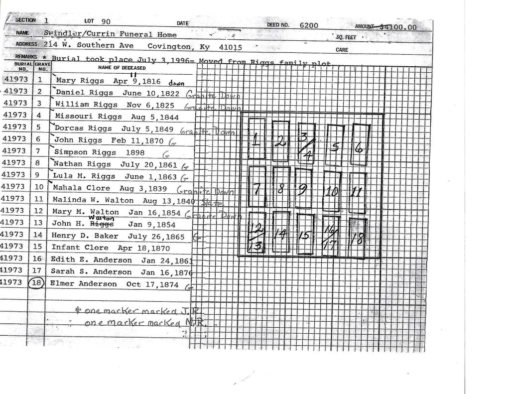
| Description | : | The cemetery is listed as Riggs Cemetery on pages 81-82 of Small Kenton County, Kentucky, Cemeteries, published by the Kenton County Historical Society, Cemetery Committee, and on pages 81-82 of Kenton County Cemeteries, published by the Kenton County Historical Society, Covington, Kentucky, 1981. The cemetery inscriptions were recorded in October 1978, reporting 18 graves with tombstones identifiable by inscription and no unidentifiable graves. The cemetery location is given as latitude 39° 02’ 58” and longitude 84° 36’ 50” in the Covington Quadrangle. The cemetery location is described as “East of I-275, 500 ft north of Dolwick Rd, ½ mi from... Read More |
frequently asked questions (FAQ):
-
Where is Riggs Cemetery (Defunct)?
Riggs Cemetery (Defunct) is located at Pacific Avenue Crescent Springs, Kenton County ,Kentucky , 41018USA.
-
Riggs Cemetery (Defunct) cemetery's updated grave count on graveviews.com?
0 memorials
-
Where are the coordinates of the Riggs Cemetery (Defunct)?
Latitude: 39.0494440
Longitude: -84.6138890
Nearby Cemetories:
1. Tupman Cemetery
Villa Hills, Kenton County, USA
Coordinate: 39.0528600, -84.6153440
2. Walton Cemetery
Hebron, Boone County, USA
Coordinate: 39.0456700, -84.6198900
3. Brown Family Cemetery
Florence, Boone County, USA
Coordinate: 39.0548528, -84.6346639
4. Passionist Monastery Cemetery
Erlanger, Kenton County, USA
Coordinate: 39.0350600, -84.6305300
5. Saint Walburg Cemetery
Villa Hills, Kenton County, USA
Coordinate: 39.0671860, -84.6001990
6. Saint Pius X Seminary Cemetery
Florence, Boone County, USA
Coordinate: 39.0289460, -84.6280990
7. Hood Cemetery
Hebron, Boone County, USA
Coordinate: 39.0708008, -84.6363983
8. Constance Cemetery
Constance, Boone County, USA
Coordinate: 39.0737306, -84.6356694
9. Masters Cemetery
Constance, Boone County, USA
Coordinate: 39.0675000, -84.6444440
10. Masters Cemetery #02
Constance, Boone County, USA
Coordinate: 39.0702780, -84.6441670
11. Casey Cemetery
Edgewood, Kenton County, USA
Coordinate: 39.0254170, -84.5865000
12. Peeno Cemetery #02
Constance, Boone County, USA
Coordinate: 39.0725000, -84.6455560
13. Peeno Cemetery
Constance, Boone County, USA
Coordinate: 39.0752983, -84.6446991
14. Beechwood Farm Cemetery
Crestview Hills, Kenton County, USA
Coordinate: 39.0304020, -84.5756360
15. Stevenson Cemetery (Defunct)
Edgewood, Kenton County, USA
Coordinate: 39.0163320, -84.5980660
16. Cleveland-McKay Family Cemetery
Villa Hills, Kenton County, USA
Coordinate: 39.0736230, -84.5802230
17. Perry Family Burying Ground
Lakeside Park, Kenton County, USA
Coordinate: 39.0333600, -84.5724130
18. Forest Lawn Memorial Park
Erlanger, Kenton County, USA
Coordinate: 39.0163994, -84.5932999
19. Saldridge Cemetery
Crescent Springs, Kenton County, USA
Coordinate: 39.0620860, -84.5690090
20. Mount Alverno Cemetery (Defunct)
Delhi, Hamilton County, USA
Coordinate: 39.0863890, -84.6083330
21. McNeal Family Cemetery
Florence, Boone County, USA
Coordinate: 39.0638790, -84.6581350
22. Reinhart Family Cemetery
Crescent Springs, Kenton County, USA
Coordinate: 39.0672510, -84.5707150
23. Flournoy Family Cemetery
Crescent Springs, Kenton County, USA
Coordinate: 39.0672830, -84.5706660
24. Brown Cemetery
Hebron, Boone County, USA
Coordinate: 39.0377780, -84.6613890

