
| Memorials | : | 0 |
| Location | : | Edgewood, Kenton County, USA |
| Coordinate | : | 39.0163320, -84.5980660 |
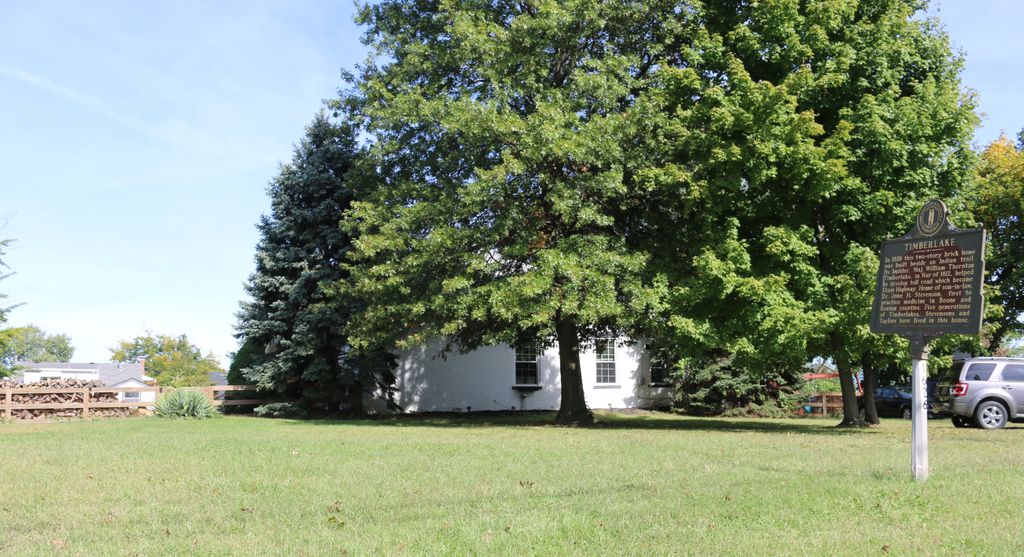
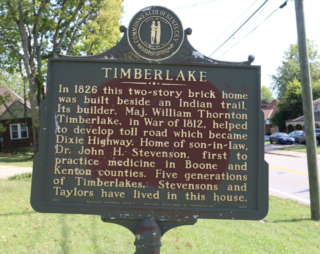
| Description | : | The cemetery was located in the area now occupied by Elizabeth Street, which was part of the property to the northeast of the Stevenson / Timberlake Home. All burials and markers were moved to the Highland Cemetery. The cemetery is listed as Stevenson Cemetery (Timberlake Cemetery) on page 101 of Small Kenton County, Kentucky, Cemeteries, published by the Kenton County Historical Society, Cemetery Committee, and on page 101 of Kenton County Cemeteries, published by the Kenton County Historical Society, Covington, Kentucky, 1981. No cemetery inscriptions were recorded. The cemetery location is given as latitude 39° 01’ 05” and... Read More |
frequently asked questions (FAQ):
-
Where is Stevenson Cemetery (Defunct)?
Stevenson Cemetery (Defunct) is located at Elizabeth Street Edgewood, Kenton County ,Kentucky , 41018USA.
-
Stevenson Cemetery (Defunct) cemetery's updated grave count on graveviews.com?
0 memorials
-
Where are the coordinates of the Stevenson Cemetery (Defunct)?
Latitude: 39.0163320
Longitude: -84.5980660
Nearby Cemetories:
1. Forest Lawn Memorial Park
Erlanger, Kenton County, USA
Coordinate: 39.0163994, -84.5932999
2. French Cemetery
Elsmere, Kenton County, USA
Coordinate: 39.0077780, -84.5944500
3. Casey Cemetery
Edgewood, Kenton County, USA
Coordinate: 39.0254170, -84.5865000
4. Mary E. Smith Cemetery
Elsmere, Kenton County, USA
Coordinate: 39.0029060, -84.5938560
5. Yager Cemetery
Erlanger, Kenton County, USA
Coordinate: 39.0027780, -84.5933330
6. Dry Creek Baptist Church Cemetery
Edgewood, Kenton County, USA
Coordinate: 39.0183330, -84.5769440
7. Beechwood Farm Cemetery
Crestview Hills, Kenton County, USA
Coordinate: 39.0304020, -84.5756360
8. Wilhoit Cemetery
Florence, Boone County, USA
Coordinate: 38.9974070, -84.6187990
9. Ashbrook-Cheek Cemetery (Defunct)
Florence, Boone County, USA
Coordinate: 39.0116670, -84.6308350
10. Perry Family Burying Ground
Lakeside Park, Kenton County, USA
Coordinate: 39.0333600, -84.5724130
11. Saint Pius X Seminary Cemetery
Florence, Boone County, USA
Coordinate: 39.0289460, -84.6280990
12. Clutterbuck Cemetery
Florence, Boone County, USA
Coordinate: 39.0041670, -84.6297230
13. Florence Cemetery
Florence, Boone County, USA
Coordinate: 39.0001000, -84.6309800
14. Passionist Monastery Cemetery
Erlanger, Kenton County, USA
Coordinate: 39.0350600, -84.6305300
15. Jarrell Cemetery
Erlanger, Kenton County, USA
Coordinate: 38.9901000, -84.5754870
16. Walton Cemetery
Hebron, Boone County, USA
Coordinate: 39.0456700, -84.6198900
17. Carpenter Family Cemetery
Florence, Boone County, USA
Coordinate: 38.9914700, -84.6298610
18. Riggs Cemetery (Defunct)
Crescent Springs, Kenton County, USA
Coordinate: 39.0494440, -84.6138890
19. Joshua Zimmerman Cemetery
Florence, Boone County, USA
Coordinate: 39.0074220, -84.6462590
20. Cain Cemetery
Edgewood, Kenton County, USA
Coordinate: 38.9905560, -84.5611110
21. Tupman Cemetery
Villa Hills, Kenton County, USA
Coordinate: 39.0528600, -84.6153440
22. Hoffman-Grubbs Cemetery
Florence, Boone County, USA
Coordinate: 38.9841670, -84.6283330
23. Ephriam Tanner Cemetery
Florence, Boone County, USA
Coordinate: 38.9880810, -84.6350260
24. John Stephens Cemetery
Florence, Boone County, USA
Coordinate: 38.9779730, -84.6171670