
| Memorials | : | 733 |
| Location | : | Westbury-on-Severn, Forest of Dean District, England |
| Coordinate | : | 51.8228858, -2.4117957 |
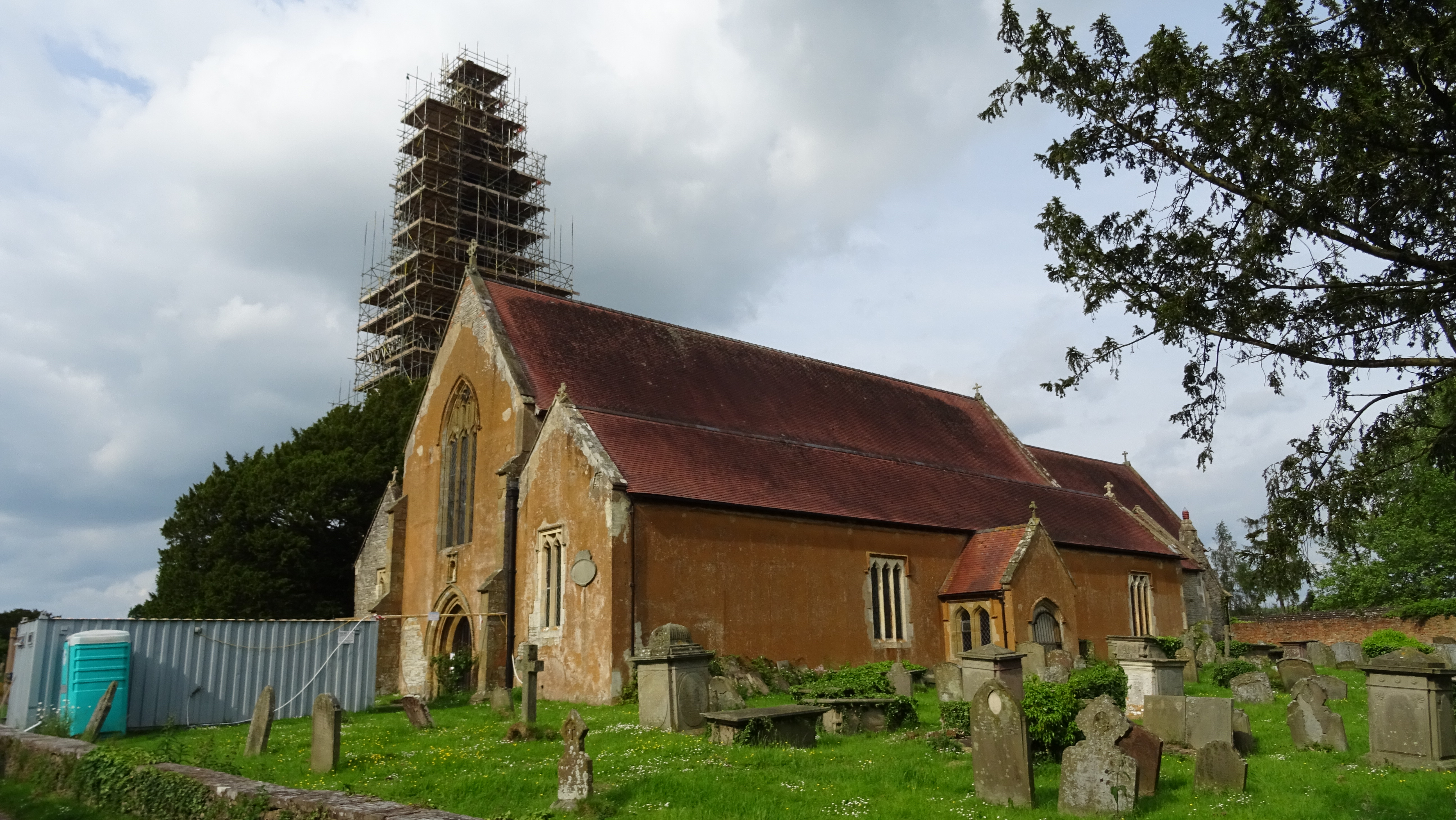
| Description | : | The parish church of St Mary, St Peter and St Paul is located in the small village of Westbury-on-Severn in Gloucestershire. The oldest parts still remaining are the north porch and north aisle, which were built in 1290. The chancel is largely 14th century, with ‘Decorated Gothic’ windows. It is an enormous church, the length of two cricket pitches, which suggests its historic importance in the area. A few yards away from the main building is a separate stone bell tower which is probably the only surviving part of an earlier church. Cromwell’s soldiers stabled their... Read More |
frequently asked questions (FAQ):
-
Where is Saint Peter and Saint Paul Churchyard?
Saint Peter and Saint Paul Churchyard is located at Westbury-on-Severn, Forest of Dean District ,Gloucestershire ,England.
-
Saint Peter and Saint Paul Churchyard cemetery's updated grave count on graveviews.com?
733 memorials
-
Where are the coordinates of the Saint Peter and Saint Paul Churchyard?
Latitude: 51.8228858
Longitude: -2.4117957
Nearby Cemetories:
1. Flaxley Abbey
Flaxley, Forest of Dean District, England
Coordinate: 51.8362390, -2.4511420
2. St Mary the Virgin Churchyard
Flaxley, Forest of Dean District, England
Coordinate: 51.8356600, -2.4535600
3. St. Mary the Virgin Churchyard
Arlingham, Stroud District, England
Coordinate: 51.7940080, -2.4263290
4. St. Peter's Churchyard
Newnham, Forest of Dean District, England
Coordinate: 51.8015700, -2.4501300
5. St. Peter's Church
Stroud District, England
Coordinate: 51.7927144, -2.3752327
6. St. Laurence Churchyard
Longney, Stroud District, England
Coordinate: 51.8100627, -2.3441589
7. St Mary the Virgin Churchyard
Fretherne, Stroud District, England
Coordinate: 51.7804140, -2.3873960
8. St John the Baptist Churchyard
Huntley, Forest of Dean District, England
Coordinate: 51.8712980, -2.4068210
9. St. Michael's Churchyard
Abenhall, Forest of Dean District, England
Coordinate: 51.8544700, -2.4786520
10. St James the Great Churchyard
Saul, Stroud District, England
Coordinate: 51.7830000, -2.3548500
11. St. Peter's Churchyard
Minsterworth, Tewkesbury Borough, England
Coordinate: 51.8511500, -2.3307800
12. St Andrews Churchyard
Whitminster, Stroud District, England
Coordinate: 51.7798400, -2.3487000
13. St John The Evangelist Churchyard
Cinderford, Forest of Dean District, England
Coordinate: 51.8125630, -2.5050510
14. St. Andrew's Churchyard
Churcham, Forest of Dean District, England
Coordinate: 51.8618970, -2.3375000
15. All Saints Churchyard
Longhope, Forest of Dean District, England
Coordinate: 51.8756910, -2.4597020
16. St. Michael and all Angels Churchyard
Mitcheldean, Forest of Dean District, England
Coordinate: 51.8646000, -2.4904000
17. Holy Trinity Churchyard
Drybrook, Forest of Dean District, England
Coordinate: 51.8460500, -2.5125400
18. St Mary Churchyard
Frampton-on-Severn, Stroud District, England
Coordinate: 51.7605650, -2.3730980
19. St. Stephen's Churchyard
Moreton Valence, Stroud District, England
Coordinate: 51.7857492, -2.3208765
20. St Nicholas Churchyard
Hardwicke, Stroud District, England
Coordinate: 51.8101200, -2.3007300
21. Forest of Dean Crematorium
Cinderford, Forest of Dean District, England
Coordinate: 51.8098440, -2.5259280
22. All Saints Churchyard
Blakeney, Forest of Dean District, England
Coordinate: 51.7615380, -2.4765280
23. St. James' Churchyard
Quedgeley, City of Gloucester, England
Coordinate: 51.8257770, -2.2811150
24. All Saints Churchyard
Viney Hill, Forest of Dean District, England
Coordinate: 51.7569980, -2.5017310