
| Memorials | : | 86 |
| Location | : | Longney, Stroud District, England |
| Coordinate | : | 51.8100627, -2.3441589 |
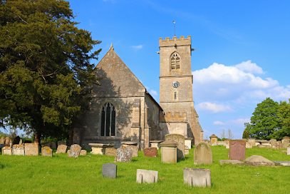
| Description | : | The church dates from the 13th century and has a 14th century tower. It has been designated as a Grade I listed building. The ecclesiastical parish is part of the benefice of Hardwicke and Elmore with Longney which is part of the Diocese of Gloucester. |
frequently asked questions (FAQ):
-
Where is St. Laurence Churchyard?
St. Laurence Churchyard is located at Longney, Stroud District ,Gloucestershire ,England.
-
St. Laurence Churchyard cemetery's updated grave count on graveviews.com?
86 memorials
-
Where are the coordinates of the St. Laurence Churchyard?
Latitude: 51.8100627
Longitude: -2.3441589
Nearby Cemetories:
1. St. Peter's Church
Stroud District, England
Coordinate: 51.7927144, -2.3752327
2. St Nicholas Churchyard
Hardwicke, Stroud District, England
Coordinate: 51.8101200, -2.3007300
3. St James the Great Churchyard
Saul, Stroud District, England
Coordinate: 51.7830000, -2.3548500
4. St. Stephen's Churchyard
Moreton Valence, Stroud District, England
Coordinate: 51.7857492, -2.3208765
5. St Andrews Churchyard
Whitminster, Stroud District, England
Coordinate: 51.7798400, -2.3487000
6. St Mary the Virgin Churchyard
Fretherne, Stroud District, England
Coordinate: 51.7804140, -2.3873960
7. St. Peter's Churchyard
Minsterworth, Tewkesbury Borough, England
Coordinate: 51.8511500, -2.3307800
8. St. James' Churchyard
Quedgeley, City of Gloucester, England
Coordinate: 51.8257770, -2.2811150
9. Saint Peter and Saint Paul Churchyard
Westbury-on-Severn, Forest of Dean District, England
Coordinate: 51.8228858, -2.4117957
10. St. Peter's Churchyard
Haresfield, Stroud District, England
Coordinate: 51.7921323, -2.2767870
11. St. Andrew's Churchyard
Churcham, Forest of Dean District, England
Coordinate: 51.8618970, -2.3375000
12. St Mary Churchyard
Frampton-on-Severn, Stroud District, England
Coordinate: 51.7605650, -2.3730980
13. St. Mary the Virgin Churchyard
Arlingham, Stroud District, England
Coordinate: 51.7940080, -2.4263290
14. St. Swithun's Churchyard
Hempsted, City of Gloucester, England
Coordinate: 51.8515740, -2.2719420
15. St. Michael and All Angels Churchyard
Eastington, Stroud District, England
Coordinate: 51.7501680, -2.3161330
16. St Margaret Church
Whaddon, Stroud District, England
Coordinate: 51.8214600, -2.2433000
17. St. Swithun Churchyard
Brookthorpe, Stroud District, England
Coordinate: 51.8087500, -2.2402900
18. St. Peter's Churchyard
Newnham, Forest of Dean District, England
Coordinate: 51.8015700, -2.4501300
19. St John the Baptist Churchyard
Harescombe, Stroud District, England
Coordinate: 51.7921570, -2.2373260
20. Holy Innocents Churchyard
Highnam, Tewkesbury Borough, England
Coordinate: 51.8740890, -2.2970050
21. Flaxley Abbey
Flaxley, Forest of Dean District, England
Coordinate: 51.8362390, -2.4511420
22. St Mary the Virgin Churchyard
Flaxley, Forest of Dean District, England
Coordinate: 51.8356600, -2.4535600
23. St John the Baptist Churchyard
Huntley, Forest of Dean District, England
Coordinate: 51.8712980, -2.4068210
24. Llanthony Secunda Priory
Hempsted, City of Gloucester, England
Coordinate: 51.8602130, -2.2572640