| Memorials | : | 0 |
| Location | : | Felbridge, Tandridge District, England |
| Coordinate | : | 51.1414480, -0.0392460 |
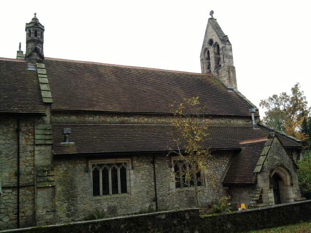
| Description | : | The church of St. John The Devine, Felbridge, was built in 1865, and a parish was formed out of the southern extremities of Godstone and Tandridge, which had originally been included in Blindley Heath, with part of East Grinstead in the county of Sussex and diocese of Chichester. The building is in stone, of 13th-century style, with a western bell-turret. |
frequently asked questions (FAQ):
-
Where is St John The Divine?
St John The Divine is located at Felbridge, Tandridge District ,Surrey ,England.
-
St John The Divine cemetery's updated grave count on graveviews.com?
0 memorials
-
Where are the coordinates of the St John The Divine?
Latitude: 51.1414480
Longitude: -0.0392460
Nearby Cemetories:
1. Mount Noddy Cemetery
East Grinstead, Mid Sussex District, England
Coordinate: 51.1316231, -0.0066281
2. St. Swithun's Churchyard
East Grinstead, Mid Sussex District, England
Coordinate: 51.1240380, -0.0058020
3. St John the Evangelist Churchyard
Dormansland, Tandridge District, England
Coordinate: 51.1597320, 0.0054300
4. All Saints Churchyard
Crawley Down, Mid Sussex District, England
Coordinate: 51.1211200, -0.0830650
5. Dormansland Baptist Chapelyard
Dormansland, Tandridge District, England
Coordinate: 51.1634300, 0.0073300
6. St Peter and St Paul Churchyard
Lingfield, Tandridge District, England
Coordinate: 51.1763840, -0.0142480
7. St John the Evangelist Churchyard
Copthorne, Crawley Borough, England
Coordinate: 51.1394100, -0.1175700
8. St Leonard's Church
Turners Hill, Mid Sussex District, England
Coordinate: 51.1023030, -0.0911310
9. St. Mary the Virgin Churchyard
Horne, Tandridge District, England
Coordinate: 51.1827330, -0.0886630
10. St. John the Evangelist Churchyard
Blindley Heath, Tandridge District, England
Coordinate: 51.1961510, -0.0536070
11. St Bartholomew Churchyard
Burstow, Tandridge District, England
Coordinate: 51.1558610, -0.1247750
12. Smallfield Ebenezer Chapel Cemetery
Smallfield, Tandridge District, England
Coordinate: 51.1770230, -0.1151960
13. Forest Row Cemetery
Forest Row, Wealden District, England
Coordinate: 51.0965560, 0.0299760
14. Holy Trinity Churchyard
Forest Row, Wealden District, England
Coordinate: 51.0980712, 0.0330168
15. St Margaret of Antioch Churchyard
West Hoathly, Mid Sussex District, England
Coordinate: 51.0762500, -0.0555430
16. Surrey and Sussex Crematorium
Crawley, Crawley Borough, England
Coordinate: 51.1357000, -0.1469230
17. St Nicholas Churchyard
Worth, Mid Sussex District, England
Coordinate: 51.1102870, -0.1415280
18. St John the Baptist Churchyard
Outwood, Tandridge District, England
Coordinate: 51.1981770, -0.1127510
19. St. Peter's Churchyard
Holtye, Wealden District, England
Coordinate: 51.1338783, 0.0821108
20. St. Lawrence's Catholic Churchyard
Edenbridge, Sevenoaks District, England
Coordinate: 51.1951354, 0.0654156
21. Cowden New Burial Ground
Cowden, Sevenoaks District, England
Coordinate: 51.1447210, 0.0958650
22. St Peter and St Paul Churchyard
Edenbridge, Sevenoaks District, England
Coordinate: 51.1959000, 0.0661400
23. Edenbridge Cemetery
Edenbridge, Sevenoaks District, England
Coordinate: 51.1962400, 0.0680000
24. All Saints Churchyard
Highbrook, Mid Sussex District, England
Coordinate: 51.0547981, -0.0573000

