
| Memorials | : | 0 |
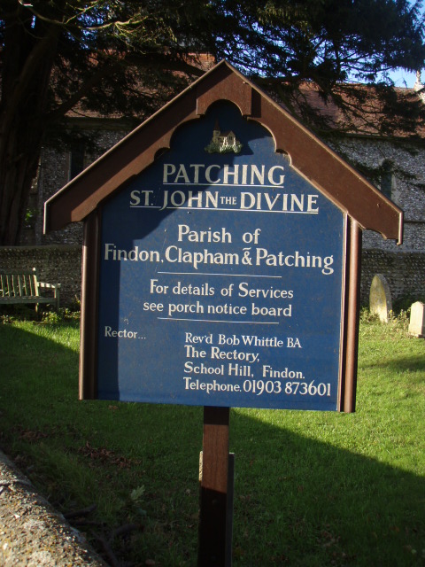
| Location | : | Patching, Arun District, England |
| Coordinate | : | 50.8485920, -0.4570270 |
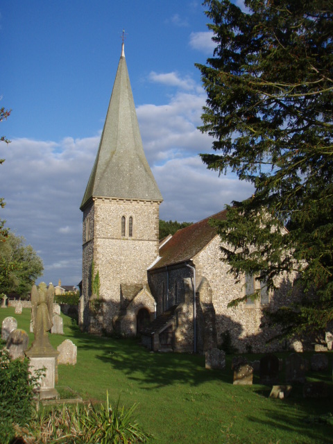
| Description | : | In the centre of the village is the 13th century Church of St John the Divine, restored in 1888. The Church has the simple early English lancet windows of its period. In spite of the smallness of the population, the Church was once considerably larger. There was probably a north aisle with the tower at its end, continued by an aisle or chapel on the north side of the chancel. Moreover the west end of the present nave has clearly been shortened but it is not known when these changes took place. A distinguished authority of 1830 states... Read More |
frequently asked questions (FAQ):
-
Where is St John the Divine Churchyard?
St John the Divine Churchyard is located at The Street Patching, Arun District ,West Sussex , BN13 3XFEngland.
-
St John the Divine Churchyard cemetery's updated grave count on graveviews.com?
0 memorials
-
Where are the coordinates of the St John the Divine Churchyard?
Latitude: 50.8485920
Longitude: -0.4570270
Nearby Cemetories:
1. Church of Saint Mary the Virgin
Clapham, Arun District, England
Coordinate: 50.8487294, -0.4446710
2. St Wilfrid Roman Catholic Cemetery
Angmering, Arun District, England
Coordinate: 50.8300437, -0.4858832
3. St. Margaret's Parish Churchyard
Angmering, Arun District, England
Coordinate: 50.8289920, -0.4860946
4. St John the Baptist Churchyard
Findon, Arun District, England
Coordinate: 50.8650400, -0.4148790
5. Findon Cemetery
Findon, Arun District, England
Coordinate: 50.8678500, -0.4100500
6. St Andrew's Churchyard
Ferring, Arun District, England
Coordinate: 50.8125800, -0.4482200
7. Worthing Crematorium
Findon, Arun District, England
Coordinate: 50.8728370, -0.4085170
8. St Nicholas Churchyard
Poling, Arun District, England
Coordinate: 50.8315400, -0.5144600
9. St Mary Churchyard
Goring-by-Sea, Worthing Borough, England
Coordinate: 50.8129310, -0.4245400
10. Durrington Cemetery
Durrington, Worthing Borough, England
Coordinate: 50.8390820, -0.3934460
11. St Mary the Virgin Churchyard
East Preston, Arun District, England
Coordinate: 50.8125610, -0.4897360
12. Brookside Cemetery
Rustington, Arun District, England
Coordinate: 50.8182133, -0.5048826
13. St Andrew Churchyard
Tarring, Worthing Borough, England
Coordinate: 50.8247000, -0.3956000
14. St. Mary the Virgin Churchyard
Burpham, Arun District, England
Coordinate: 50.8709730, -0.5244080
15. St Peter and St Paul Churchyard
Rustington, Arun District, England
Coordinate: 50.8103200, -0.5107400
16. Convent of Poor Clare Cemetery
Arundel, Arun District, England
Coordinate: 50.8468960, -0.5381370
17. Broadwater Cemetery
Worthing, Worthing Borough, England
Coordinate: 50.8277650, -0.3799460
18. Littlehampton Cemetery
Littlehampton, Arun District, England
Coordinate: 50.8190710, -0.5282800
19. St Matthew Churchyard
Worthing, Worthing Borough, England
Coordinate: 50.8178900, -0.3830100
20. St Marys Churchyard
Broadwater, Worthing Borough, England
Coordinate: 50.8277750, -0.3734920
21. Heene Cemetery
Worthing, Worthing Borough, England
Coordinate: 50.8121180, -0.3881260
22. Saint Marys Churchyard
Sullington, Horsham District, England
Coordinate: 50.9070090, -0.4391640
23. St Mary Magdalene Churchyard
Lyminster, Arun District, England
Coordinate: 50.8335650, -0.5485680
24. St Andrew the Apostle Churchyard
Worthing, Worthing Borough, England
Coordinate: 50.8153000, -0.3774100