
| Memorials | : | 15 |
| Location | : | Bourton-on-the-Hill, Cotswold District, England |
| Coordinate | : | 52.0531830, -1.7758910 |
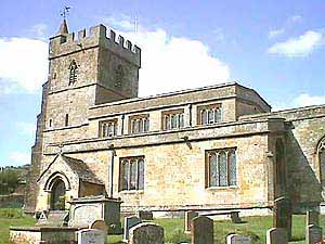
| Description | : | Bourton-on-the-Hill is a village and civil parish in the Cotswold district of Gloucestershire, England, about two miles west of Moreton-in-Marsh. Coordinates: 51‹59ŒN 1‹45ŒW |
frequently asked questions (FAQ):
-
Where is St Lawrence Churchyard?
St Lawrence Churchyard is located at Bourton-on-the-Hill, Cotswold District ,Gloucestershire ,England.
-
St Lawrence Churchyard cemetery's updated grave count on graveviews.com?
15 memorials
-
Where are the coordinates of the St Lawrence Churchyard?
Latitude: 52.0531830
Longitude: -1.7758910
Nearby Cemetories:
1. St James Churchyard
Chipping Campden, Cotswold District, England
Coordinate: 52.0532670, -1.7758760
2. St Catherine's Cemetery
Chipping Campden, Cotswold District, England
Coordinate: 52.0495800, -1.7850600
3. St Andrew's Church
Aston Subedge, Cotswold District, England
Coordinate: 52.0729286, -1.7994658
4. St. Lawrence's Churchyard
Mickleton, Cotswold District, England
Coordinate: 52.0895200, -1.7653900
5. St. Peter and St. Paul's Churchyard
Blockley, Cotswold District, England
Coordinate: 52.0124600, -1.7617000
6. St. Ecgwin Churchyard
Honeybourne, Wychavon District, England
Coordinate: 52.0946646, -1.8262611
7. St Saviour's Roman Catholic Churchyard
Broadway, Wychavon District, England
Coordinate: 52.0385690, -1.8569250
8. Honeybourne Cemetery
Honeybourne, Wychavon District, England
Coordinate: 52.0957393, -1.8266225
9. St Eadburgha Churchyard
Broadway, Wychavon District, England
Coordinate: 52.0343100, -1.8632560
10. St. Michael and All Angels Churchyard
Broadway, Wychavon District, England
Coordinate: 52.0343270, -1.8632960
11. St Marys Churchyard
Batsford, Cotswold District, England
Coordinate: 52.0030800, -1.7291600
12. St. Eadburgha New Churchyard
Broadway, Wychavon District, England
Coordinate: 52.0223000, -1.8591500
13. St. Mary the Virgin Churchyard
Ilmington, Stratford-on-Avon District, England
Coordinate: 52.0892430, -1.6955030
14. St. Peter's Churchyard
Stretton-on-Fosse, Stratford-on-Avon District, England
Coordinate: 52.0430778, -1.6754209
15. Stretton Cemetery
Stretton-on-Fosse, Stratford-on-Avon District, England
Coordinate: 52.0413935, -1.6733470
16. Bretforton Cemetery
Bretforton, Wychavon District, England
Coordinate: 52.0935996, -1.8625984
17. St. Leonard's Churchyard
Bretforton, Wychavon District, England
Coordinate: 52.0926100, -1.8657200
18. St. Peter's Churchyard
Pebworth, Wychavon District, England
Coordinate: 52.1200720, -1.8137810
19. St Mary's Churchyard
Childswickham, Wychavon District, England
Coordinate: 52.0440000, -1.8919000
20. St. Michael Churchyard Extension
Buckland, Tewkesbury Borough, England
Coordinate: 52.0223380, -1.8816020
21. St. Swithin Churchyard Extension
Quinton, Stratford-on-Avon District, England
Coordinate: 52.1209500, -1.7326740
22. St Leonard's
Moreton-in-Marsh, Cotswold District, England
Coordinate: 52.0087019, -1.6822226
23. St. Swithin's Churchyard
Quinton, Stratford-on-Avon District, England
Coordinate: 52.1213370, -1.7334890
24. St Barnabas Churchyard
Snowshill, Tewkesbury Borough, England
Coordinate: 52.0017600, -1.8608100