
| Memorials | : | 0 |
| Location | : | Drayton St Leonard, South Oxfordshire District, England |
| Phone | : | 01865 340007 |
| Website | : | www.achurchnearyou.com/church/95/ |
| Coordinate | : | 51.6640020, -1.1387005 |
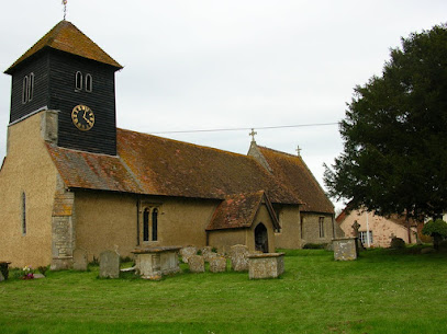
| Description | : | The small village church of St Leonard and St Catherine in Drayton St Leonard has been worshipped in for over 800 years. Much of the Nave is Norman, with two fine doorways, although the Chancel was added later. Its most striking feature is the free-standing tower, built of massive oak and chestnut beams standing within the main building and rising through the roof to a height of 43 feet. Internally the Victorian restoration aimed to return the church to the style in which it was originally built. |
frequently asked questions (FAQ):
-
Where is St Leonard and St Catherine?
St Leonard and St Catherine is located at Church Lane, Drayton St Leonard, Oxfordshire Drayton St Leonard, South Oxfordshire District ,Oxfordshire , OX10 7AUEngland.
-
St Leonard and St Catherine cemetery's updated grave count on graveviews.com?
0 memorials
-
Where are the coordinates of the St Leonard and St Catherine?
Latitude: 51.6640020
Longitude: -1.1387005
Nearby Cemetories:
1. St Giles Churchyard
Newington, South Oxfordshire District, England
Coordinate: 51.6638800, -1.1207600
2. St John the Baptist Churchyard
Stadhampton, South Oxfordshire District, England
Coordinate: 51.6848390, -1.1279600
3. Dorchester Cemetery
Dorchester, South Oxfordshire District, England
Coordinate: 51.6478130, -1.1649480
4. St Laurence Churchyard
Warborough, South Oxfordshire District, England
Coordinate: 51.6383330, -1.1358310
5. Dorchester Abbey
Dorchester, South Oxfordshire District, England
Coordinate: 51.6436250, -1.1644290
6. Friends Burying Ground
Warborough, South Oxfordshire District, England
Coordinate: 51.6374080, -1.1354510
7. Saint Birinus Catholic Churchyard
Dorchester, South Oxfordshire District, England
Coordinate: 51.6412600, -1.1649100
8. St Mary's Church Cemetery
Chalgrove, South Oxfordshire District, England
Coordinate: 51.6641000, -1.0802000
9. St. Peter's Churchyard
Little Wittenham, South Oxfordshire District, England
Coordinate: 51.6369880, -1.1830625
10. St James Churchyard
Little Milton, South Oxfordshire District, England
Coordinate: 51.7019280, -1.1072800
11. St Peter Churchyard
Marsh Baldon, South Oxfordshire District, England
Coordinate: 51.6941870, -1.1884550
12. St Michael Churchyard
Clifton Hampden, South Oxfordshire District, England
Coordinate: 51.6558680, -1.2103840
13. Benson War Memorial
Benson, South Oxfordshire District, England
Coordinate: 51.6207890, -1.1108700
14. St. Helen's Churchyard
Benson, South Oxfordshire District, England
Coordinate: 51.6200200, -1.1127400
15. St. Helen Churchyard Extension
Benson, South Oxfordshire District, England
Coordinate: 51.6201400, -1.1121200
16. St Lawrence Churchyard
Toot Baldon, South Oxfordshire District, England
Coordinate: 51.7051720, -1.1750220
17. All Saints Parish Churchyard
Nuneham Courtenay, South Oxfordshire District, England
Coordinate: 51.6882380, -1.2057616
18. St Mary the Virgin Churchyard
Long Wittenham, South Oxfordshire District, England
Coordinate: 51.6423650, -1.2092860
19. Saint Mary's Churchyard
Garsington, South Oxfordshire District, England
Coordinate: 51.7140100, -1.1600700
20. Old All Saints Church
Nuneham Courtenay, South Oxfordshire District, England
Coordinate: 51.6805300, -1.2181300
21. Brightwell Baldwin St Bartholomews Churchyard
Brightwell Baldwin, South Oxfordshire District, England
Coordinate: 51.6500670, -1.0569610
22. Saint James Churchyard
Brightwell cum Sotwell, South Oxfordshire District, England
Coordinate: 51.6120200, -1.1549800
23. St. Agatha New Churchyard
Brightwell cum Sotwell, South Oxfordshire District, England
Coordinate: 51.6131480, -1.1665480
24. St Peter Churchyard
Easington, South Oxfordshire District, England
Coordinate: 51.6684300, -1.0443070