
| Memorials | : | 0 |
| Location | : | Stafford, Stafford Borough, England |
| Coordinate | : | 52.8057000, -2.1187000 |
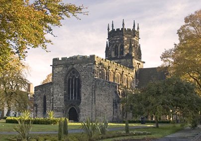
| Description | : | St. Mary's Church was built on the foundations of St. Bertelin's Chapel of the ninth century. The present church dates from the early 13th century, with 14th century transepts and 15th century clerestories and crossing tower. It was heavily restored by Sir George Gilbert Scott between 1841 and 1844. The church was collegiate when recorded in the Domesday Book in 1086. The church survived as a collegiate institution until the dissolution of colleges and chantries in 1548. For several generations the Aston family acted as patrons, despite the fact that the entire family converted to Catholicism... Read More |
frequently asked questions (FAQ):
-
Where is St. Mary's Churchyard?
St. Mary's Churchyard is located at Stafford, Stafford Borough ,Staffordshire , ST16 2AREngland.
-
St. Mary's Churchyard cemetery's updated grave count on graveviews.com?
0 memorials
-
Where are the coordinates of the St. Mary's Churchyard?
Latitude: 52.8057000
Longitude: -2.1187000
Nearby Cemetories:
1. St Chad
Stafford, Stafford Borough, England
Coordinate: 52.8061611, -2.1165797
2. Stafford Prison Cemetery
Stafford, Stafford Borough, England
Coordinate: 52.8122341, -2.1166098
3. Eccleshall Road Cemetery
Stafford, Stafford Borough, England
Coordinate: 52.8158760, -2.1252976
4. Stafford Crematorium and Burial Ground
Stafford, Stafford Borough, England
Coordinate: 52.8080900, -2.0747420
5. St James the Great Church
Salt, Stafford Borough, England
Coordinate: 52.8483296, -2.0701182
6. St Mary The Virgin Churchyard
Ingestre, Stafford Borough, England
Coordinate: 52.8196420, -2.0361510
7. St. James Churchyard
Acton Trussell, South Staffordshire Borough, England
Coordinate: 52.7546980, -2.0943120
8. St Giles Churchyard
Haughton, Stafford Borough, England
Coordinate: 52.7817750, -2.2005140
9. St Mary and All Saints
Bradley, Stafford Borough, England
Coordinate: 52.7599257, -2.1808769
10. Ranton All Saints
Ranton, Stafford Borough, England
Coordinate: 52.8151300, -2.2156400
11. St. Andrew's Church
Weston, Stafford Borough, England
Coordinate: 52.8412239, -2.0391501
12. All Saints Churchyard
Sandon, Stafford Borough, England
Coordinate: 52.8628160, -2.0696270
13. St Stephen Churchyard
Great Haywood, Stafford Borough, England
Coordinate: 52.8004360, -2.0049890
14. St Peter's Church
Gayton, Stafford Borough, England
Coordinate: 52.8540363, -2.0327095
15. All Saints Churchyard
Chebsey, Stafford Borough, England
Coordinate: 52.8546150, -2.2098560
16. St. Peter's Churchyard
Hixon, Stafford Borough, England
Coordinate: 52.8273830, -2.0004581
17. Ronton Priory
Ellenhall, Stafford Borough, England
Coordinate: 52.8157600, -2.2414900
18. St Mary Churchyard
Ellenhall, Stafford Borough, England
Coordinate: 52.8360140, -2.2372270
19. St Saviour Churchyard
Aston-by-Stone, Stafford Borough, England
Coordinate: 52.8841410, -2.1283140
20. Saint Mary's Abbey
Colwich, Stafford Borough, England
Coordinate: 52.7900000, -1.9895000
21. St. Michael & All Angels Churchyard
Penkridge, South Staffordshire Borough, England
Coordinate: 52.7245874, -2.1181258
22. St. Editha's Parish Church Graveyard
Church Eaton, Stafford Borough, England
Coordinate: 52.7560690, -2.2259540
23. Stone Cemetery
Stone, Stafford Borough, England
Coordinate: 52.8874860, -2.1369430
24. St. Michael and All Angels Church
Colwich, Stafford Borough, England
Coordinate: 52.7876070, -1.9853500