| Memorials | : | 0 |
| Location | : | Colwich, Stafford Borough, England |
| Coordinate | : | 52.7900000, -1.9895000 |
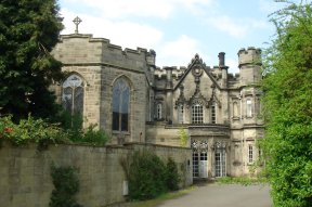
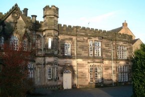
| Description | : | St Mary's Abbey of English Benedictine nuns has its origins in 1623 at Cambrai in the Spanish Netherlands. At that time, persecution made it impossible for women to become nuns in England. By 1645, the Cambrai community under Abbess Catherine Gascoigne had increased to 50 nuns, and was living in conditions of extreme poverty. On 6 February 1652, the community was established in Paris as the Priory of Our Lady of Good Hope under Dame Bridget More as their Prioress. She was a direct descendant of the martyr, St Thomas More, and had been taught at Cambrai under the spiritual supervision... Read More |
frequently asked questions (FAQ):
-
Where is Saint Mary's Abbey?
Saint Mary's Abbey is located at Colwich, Stafford Borough ,Staffordshire ,England.
-
Saint Mary's Abbey cemetery's updated grave count on graveviews.com?
0 memorials
-
Where are the coordinates of the Saint Mary's Abbey?
Latitude: 52.7900000
Longitude: -1.9895000
Nearby Cemetories:
1. St. Michael and All Angels Church
Colwich, Stafford Borough, England
Coordinate: 52.7876070, -1.9853500
2. St Stephen Churchyard
Great Haywood, Stafford Borough, England
Coordinate: 52.8004360, -2.0049890
3. St. Peter's Churchyard
Hixon, Stafford Borough, England
Coordinate: 52.8273830, -2.0004581
4. Rugeley Cemetery
Rugeley, Cannock Chase District, England
Coordinate: 52.7650720, -1.9370440
5. St Mary The Virgin Churchyard
Ingestre, Stafford Borough, England
Coordinate: 52.8196420, -2.0361510
6. The Old Chancel
Rugeley, Cannock Chase District, England
Coordinate: 52.7648400, -1.9355010
7. St. Augustine's Churchyard
Rugeley, Cannock Chase District, England
Coordinate: 52.7644253, -1.9345868
8. Stafford Crematorium and Burial Ground
Stafford, Stafford Borough, England
Coordinate: 52.8080900, -2.0747420
9. Stile Cop Cemetery
Rugeley, Cannock Chase District, England
Coordinate: 52.7423710, -1.9448220
10. Cannock Chase German Military Cemetery
Cannock, Cannock Chase District, England
Coordinate: 52.7370580, -2.0265050
11. Cannock Chase War Cemetery
Cannock, Cannock Chase District, England
Coordinate: 52.7370710, -2.0266340
12. St. Andrew's Church
Weston, Stafford Borough, England
Coordinate: 52.8412239, -2.0391501
13. St. Michael's Churchyard
Brereton, Cannock Chase District, England
Coordinate: 52.7451169, -1.9228718
14. St Peter's Church
Gayton, Stafford Borough, England
Coordinate: 52.8540363, -2.0327095
15. Hawkesyard Priory
Rugeley, Cannock Chase District, England
Coordinate: 52.7439175, -1.9032955
16. St. Nicholas Churchyard
Abbots Bromley, East Staffordshire Borough, England
Coordinate: 52.8184560, -1.8837460
17. St. James Churchyard
Acton Trussell, South Staffordshire Borough, England
Coordinate: 52.7546980, -2.0943120
18. St James the Great Church
Salt, Stafford Borough, England
Coordinate: 52.8483296, -2.0701182
19. St John the Baptist Churchyard
Armitage with Handsacre, Lichfield District, England
Coordinate: 52.7458638, -1.8851159
20. St Chad
Stafford, Stafford Borough, England
Coordinate: 52.8061611, -2.1165797
21. St. Mary's Churchyard
Stafford, Stafford Borough, England
Coordinate: 52.8057000, -2.1187000
22. Stafford Prison Cemetery
Stafford, Stafford Borough, England
Coordinate: 52.8122341, -2.1166098
23. St. Peter's Churchyard
Hednesford, Cannock Chase District, England
Coordinate: 52.7050630, -1.9918330
24. Our Lady of Lourdes Churchyard
Hednesford, Cannock Chase District, England
Coordinate: 52.7051311, -1.9969935


