
| Memorials | : | 4 |
| Location | : | Welford, Daventry District, England |
| Website | : | www.nasebygroup.org/welford-st-mary-the-virgin |
| Coordinate | : | 52.4172618, -1.0587465 |
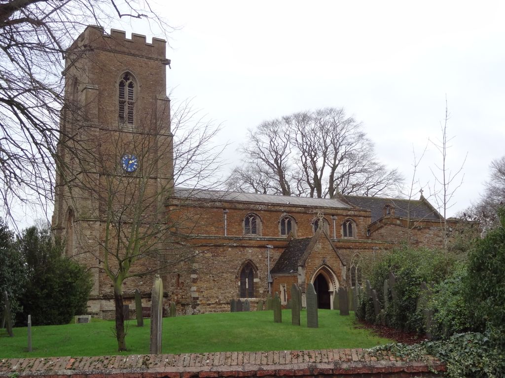
| Description | : | St. Mary’s the Virgin is the Church of England church for the parish of Welford. It is a Grade II* listed building and stands on the east side of the junction of Church Lane and West Street. There was presumably a church in Welford by 1086, when the Domesday Book records the presence of a priest there, although it does not mention a church building as such. The main structure of the present building was erected in the 13th to 15th centuries. In 1872, it was restored and the north aisle rebuilt by E. F. Law. The church now consists... Read More |
frequently asked questions (FAQ):
-
Where is St Mary the Virgin Churchyard?
St Mary the Virgin Churchyard is located at Church Lane Welford, Daventry District ,Northamptonshire ,England.
-
St Mary the Virgin Churchyard cemetery's updated grave count on graveviews.com?
1 memorials
-
Where are the coordinates of the St Mary the Virgin Churchyard?
Latitude: 52.4172618
Longitude: -1.0587465
Nearby Cemetories:
1. St. Mary's Churchyard Extension
Welford, Daventry District, England
Coordinate: 52.4173836, -1.0595687
2. Husbands Bosworth Cemetery
Husbands Bosworth, Harborough District, England
Coordinate: 52.4481064, -1.0583018
3. St. Andrew Churchyard
North Kilworth, Harborough District, England
Coordinate: 52.4432190, -1.0950880
4. St Nicholas Church
South Kilworth, Harborough District, England
Coordinate: 52.4316750, -1.1125110
5. All Saints Churchyard
Husbands Bosworth, Harborough District, England
Coordinate: 52.4536880, -1.0529010
6. St. Denys' Churchyard
Cold Ashby, Daventry District, England
Coordinate: 52.3806000, -1.0372700
7. St. Helen's Churchyard
Sibbertoft, Daventry District, England
Coordinate: 52.4386400, -0.9989200
8. All Saints Churchyard
Naseby, Daventry District, England
Coordinate: 52.3968790, -0.9889740
9. St. Nicholas's Churchyard
Stanford-on-Avon, Daventry District, England
Coordinate: 52.4045020, -1.1359770
10. St Nicholas' Churchyard
Stanford on Avon, Harborough District, England
Coordinate: 52.4045560, -1.1362100
11. St. Andrew's Churchyard
Clay Coton, Daventry District, England
Coordinate: 52.3871456, -1.1290185
12. All Saints Churchyard
Theddingworth, Harborough District, England
Coordinate: 52.4655020, -1.0185520
13. All Saints Churchyard
Yelvertoft, Daventry District, England
Coordinate: 52.3717866, -1.1164310
14. Yelvertoft Cemetery
Yelvertoft, Daventry District, England
Coordinate: 52.3707000, -1.1153400
15. Yelvertoft Independent Chapel Churchyard
Yelvertoft, Daventry District, England
Coordinate: 52.3736980, -1.1225680
16. St. Michael and All Angels Churchyard
Winwick, Daventry District, England
Coordinate: 52.3589063, -1.0820887
17. Baptist Graveyard
Clipston, Daventry District, England
Coordinate: 52.4296989, -0.9582000
18. All Saints Churchyard
Swinford, Harborough District, England
Coordinate: 52.4099260, -1.1642830
19. Greenhaven Woodland Burial Ground
Lilbourne, Daventry District, England
Coordinate: 52.3881390, -1.1545970
20. All Saints Churchyard
Clipston, Daventry District, England
Coordinate: 52.4273400, -0.9517300
21. Swinford cemetery
Swinford, Harborough District, England
Coordinate: 52.4088297, -1.1695096
22. Saint Michael's Churchyard
Haselbech, Daventry District, England
Coordinate: 52.3891890, -0.9556720
23. St. Nicholas' Churchyard
Marston Trussell, Daventry District, England
Coordinate: 52.4669200, -0.9804650
24. All Saints Churchyard
Kimcote, Harborough District, England
Coordinate: 52.4736330, -1.1390390