
| Memorials | : | 3 |
| Location | : | Merton, Cherwell District, England |
| Coordinate | : | 51.8559670, -1.1633060 |
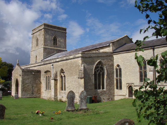
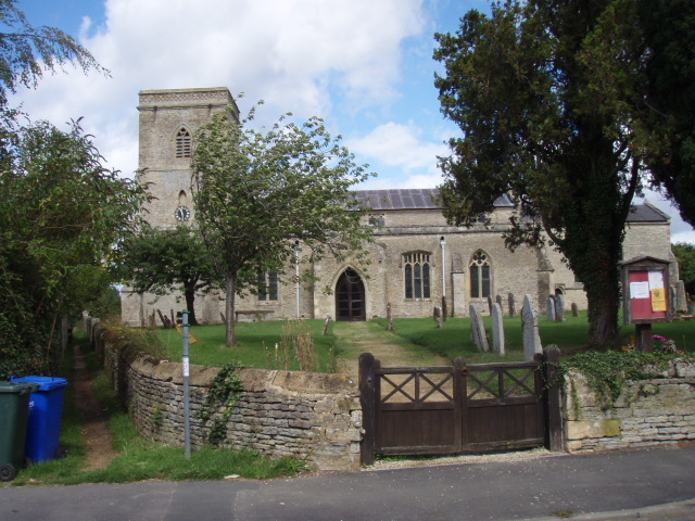
| Description | : | The church of St Swithun is almost entirely 14th Century. At one time it boasted a spire and peal of bells, but when the spire became unsafe, it had to be taken down and the work was financed by the sale of all but one of the bells. The church clock also became defunct and a few years ago the engine was replaced by an electronic device linked to the master clock at Rugby. The old engine is now on display within the church. The church is large enough to seat 200, but has no permanent system of heating. During the... Read More |
frequently asked questions (FAQ):
-
Where is St Swithuns Churchyard?
St Swithuns Churchyard is located at Merton, Cherwell District ,Oxfordshire ,England.
-
St Swithuns Churchyard cemetery's updated grave count on graveviews.com?
3 memorials
-
Where are the coordinates of the St Swithuns Churchyard?
Latitude: 51.8559670
Longitude: -1.1633060
Nearby Cemetories:
1. St Mary Church Cemetery
Charlton-on-Otmoor, Cherwell District, England
Coordinate: 51.8394100, -1.1838090
2. St. Mary the Virgin Churchyard
Charlton-on-Otmoor, Cherwell District, England
Coordinate: 51.8381510, -1.1859010
3. St Giles Churchyard
Wendlebury, Cherwell District, England
Coordinate: 51.8730580, -1.1901000
4. St Marys Churchyard
Ambrosden, Cherwell District, England
Coordinate: 51.8699990, -1.1255190
5. St Mary Churchyard
Chesterton, Cherwell District, England
Coordinate: 51.8879880, -1.1851540
6. St. Andrew Churchyard
Oddington, Cherwell District, England
Coordinate: 51.8291010, -1.1996230
7. Bicester Town Cemetery
Bicester, Cherwell District, England
Coordinate: 51.8945880, -1.1553730
8. St Edburg Churchyard
Bicester, Cherwell District, England
Coordinate: 51.8960060, -1.1541930
9. Independent Chapel Cemetery
Bicester, Cherwell District, England
Coordinate: 51.8960550, -1.1514940
10. St Marys Churchyard
Weston-on-the-Green, Cherwell District, England
Coordinate: 51.8632420, -1.2302540
11. Bicester Priory
Bicester, Cherwell District, England
Coordinate: 51.9000000, -1.1500000
12. St Barnabas Churchyard
Horton-cum-Studley, Cherwell District, England
Coordinate: 51.8077260, -1.1409690
13. St Giles Churchyard
Noke, Cherwell District, England
Coordinate: 51.8145050, -1.2114790
14. St Marys Churchyard
Launton, Cherwell District, England
Coordinate: 51.9006740, -1.1230300
15. Bethel Congregational Church
Launton, Cherwell District, England
Coordinate: 51.8979200, -1.1151020
16. Studley Priory
Horton-cum-Studley, Cherwell District, England
Coordinate: 51.8054560, -1.1346920
17. St. James' Churchyard
Boarstall, Aylesbury Vale District, England
Coordinate: 51.8218170, -1.0926460
18. St. Nicholas' Churchyard
Islip, Cherwell District, England
Coordinate: 51.8230010, -1.2375590
19. St Nicholas Churchyard
Piddington, Cherwell District, England
Coordinate: 51.8477520, -1.0723950
20. St John the Baptist Churchyard
Piddington, Cherwell District, England
Coordinate: 51.8477859, -1.0723360
21. Assumption of the Blessed Virgin Mary Churchyard
Beckley, South Oxfordshire District, England
Coordinate: 51.7972530, -1.1858920
22. St Giles Churchyard and Extension
Bletchingdon, Cherwell District, England
Coordinate: 51.8582500, -1.2655500
23. All Saints Churchyard
Middleton Stoney, Cherwell District, England
Coordinate: 51.9053470, -1.2295300
24. Woodeaton Holy Rood Churchyard
Woodeaton, South Oxfordshire District, England
Coordinate: 51.8031620, -1.2257910