
| Memorials | : | 12 |
| Location | : | Taylorsport, Boone County, USA |
| Coordinate | : | 39.0996972, -84.6945611 |
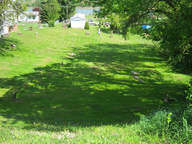
| Description | : | The cemetery is located on the northeast side of River Road (Kentucky State Highway 8) about 200 feet northwest of its intersection with Taylorsport Drive. The Boone County GIS unique ID assigned to this cemetery is 167 (Taylorsport Cemetery). The cemetery has an index number of 169 (Taylorsport Cemetery) on the Boone County Kentucky Cemetery Map published in 2005 by the Boone County Planning Commission in conjunction with Johnson-Wilson Cemetery Stewards Association. The cemetery is identified as Taylorsport in the index and listed as Taylorsport Cemetery on page 57 of the book “Boone County, Kentucky Cemeteries” by Stephen W. Worrel, M.A. & Anne... Read More |
frequently asked questions (FAQ):
-
Where is Taylorsport Cemetery?
Taylorsport Cemetery is located at 6438 River Road (Kentucky State Highway 8) Taylorsport, Boone County ,Kentucky , 41048USA.
-
Taylorsport Cemetery cemetery's updated grave count on graveviews.com?
12 memorials
-
Where are the coordinates of the Taylorsport Cemetery?
Latitude: 39.0996972
Longitude: -84.6945611
Nearby Cemetories:
1. Souther Cemetery
Taylorsport, Boone County, USA
Coordinate: 39.0972830, -84.7071080
2. Sand Run Baptist Church Cemetery
Francisville, Boone County, USA
Coordinate: 39.1035156, -84.7259293
3. Graves-Duncan Cemetery
Francisville, Boone County, USA
Coordinate: 39.0963080, -84.7268580
4. Klasserner-Wilson Family Cemetery
Taylorsport, Boone County, USA
Coordinate: 39.0895810, -84.6596880
5. Hicks Cemetery
Hebron, Boone County, USA
Coordinate: 39.0711110, -84.7013890
6. Darby-Lee Cemetery
Delhi, Hamilton County, USA
Coordinate: 39.0995930, -84.6535850
7. Hebron Lutheran Church Cemetery
Hebron, Boone County, USA
Coordinate: 39.0641677, -84.6988889
8. Van Blaricum Cemetery
Mack, Hamilton County, USA
Coordinate: 39.1335040, -84.6795180
9. Sisters of Charity Cemetery
Cincinnati, Hamilton County, USA
Coordinate: 39.0992700, -84.6476200
10. Nancy Harper Cemetery (Defunct)
Stringtown, Boone County, USA
Coordinate: 39.0800000, -84.6550000
11. Schumann Cemetery
Cincinnati, Hamilton County, USA
Coordinate: 39.0926860, -84.6464460
12. Calvin Peeno Cemetery
Stringtown, Boone County, USA
Coordinate: 39.0815917, -84.6461861
13. Colonel Abraham Depew Grave
Francisville, Boone County, USA
Coordinate: 39.1102982, -84.7474976
14. Love Cemetery
Hebron, Boone County, USA
Coordinate: 39.1067060, -84.7486480
15. Watts Cemetery
Hebron, Boone County, USA
Coordinate: 39.0788994, -84.7427979
16. Laycock Farm Cemetery
Anderson Ferry, Hamilton County, USA
Coordinate: 39.0877780, -84.6399190
17. Crigler-Clore-Smith Cemetery
Hebron, Boone County, USA
Coordinate: 39.0580560, -84.7141670
18. McNeal Family Cemetery
Florence, Boone County, USA
Coordinate: 39.0638790, -84.6581350
19. Peeno Cemetery
Constance, Boone County, USA
Coordinate: 39.0752983, -84.6446991
20. Saint Johns Cemetery
Cincinnati, Hamilton County, USA
Coordinate: 39.1147003, -84.6374969
21. Peeno Cemetery #02
Constance, Boone County, USA
Coordinate: 39.0725000, -84.6455560
22. Our Lady of Victory Cemetery
Cincinnati, Hamilton County, USA
Coordinate: 39.1083100, -84.6345100
23. Delhi Township Cemetery
Delhi Hills, Hamilton County, USA
Coordinate: 39.1133430, -84.6354500
24. Markland Cemetery
Hamilton County, USA
Coordinate: 39.1479300, -84.6870800