
| Memorials | : | 0 |
| Location | : | Redfield, Bristol Unitary Authority, England |
| Coordinate | : | 51.4589300, -2.5569000 |
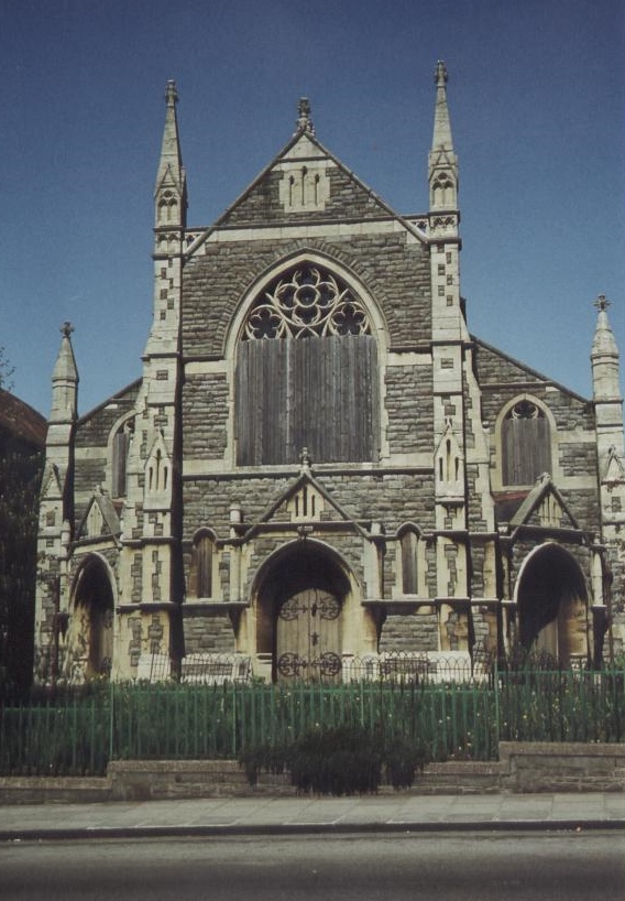
| Description | : | Redfield Wesleyan Methodist Church was, and the building still is, situated in the populous working district of East Bristol. It has a long and honourable history, linked with John Wesley. With Methodism in East Bristol on the rise Redfield eventually became part of the Kingswood circuit and as they prospered it was considered wise to construct a church for the congregation who first met in the back of a shop on Church Road. opposite Dove Lane. Land for this purpose was purchased, a trust was formed and the foundation stone for the new building was laid on 23rd August 1815. The... Read More |
frequently asked questions (FAQ):
-
Where is Wesleyan Methodist Church?
Wesleyan Methodist Church is located at Redfield, Bristol Unitary Authority ,Bristol ,England.
-
Wesleyan Methodist Church cemetery's updated grave count on graveviews.com?
0 memorials
-
Where are the coordinates of the Wesleyan Methodist Church?
Latitude: 51.4589300
Longitude: -2.5569000
Nearby Cemetories:
1. Avon View Cemetery
St George, Bristol Unitary Authority, England
Coordinate: 51.4574000, -2.5493680
2. St Luke’s Church burial ground
Barton Hill, Bristol Unitary Authority, England
Coordinate: 51.4544500, -2.5639600
3. Barton Hill School Memorial
Barton Hill, Bristol Unitary Authority, England
Coordinate: 51.4544350, -2.5640030
4. Greenbank Masjid
Easton, Bristol Unitary Authority, England
Coordinate: 51.4679410, -2.5578030
5. St Mark Churchyard
Easton, Bristol Unitary Authority, England
Coordinate: 51.4668240, -2.5646860
6. Greenbank Cemetery
Eastville, Bristol Unitary Authority, England
Coordinate: 51.4683610, -2.5540270
7. Holy Trinity Church
St Phillips, Bristol Unitary Authority, England
Coordinate: 51.4580335, -2.5760701
8. Barton Road Jewish Cemetery
St Phillips, Bristol Unitary Authority, England
Coordinate: 51.4531400, -2.5779800
9. Redcross Street Burial Ground (Defunct)
Bristol Unitary Authority, England
Coordinate: 51.4563073, -2.5833100
10. St. Mary Redcliffe Cemetery
Arnos Vale, Bristol Unitary Authority, England
Coordinate: 51.4428370, -2.5646220
11. Ridgeway Jewish Cemetery
Bristol, Bristol Unitary Authority, England
Coordinate: 51.4749930, -2.5488700
12. Holy Souls Catholic Cemetery
Arnos Vale, Bristol Unitary Authority, England
Coordinate: 51.4422800, -2.5639300
13. Ridgeway Park Cemetery
Bristol, Bristol Unitary Authority, England
Coordinate: 51.4755800, -2.5494800
14. Arnos Vale Cemetery and Crematorium
Arnos Vale, Bristol Unitary Authority, England
Coordinate: 51.4423740, -2.5648680
15. St Pauls Churchyard
Bristol, Bristol Unitary Authority, England
Coordinate: 51.4611550, -2.5847190
16. St Werburgh's Church
Bristol, Bristol Unitary Authority, England
Coordinate: 51.4717464, -2.5763725
17. St Philip and St Jacob Churchyard
Bristol, Bristol Unitary Authority, England
Coordinate: 51.4545420, -2.5844690
18. Whitfield's Tabernacle
St Pauls, Bristol Unitary Authority, England
Coordinate: 51.4579500, -2.5860800
19. Brunswick Square Unitarian Burying Ground
Bristol, Bristol Unitary Authority, England
Coordinate: 51.4605400, -2.5877800
20. Black Friars Priory
Bristol, Bristol Unitary Authority, England
Coordinate: 51.4572220, -2.5877780
21. Quakers Friars Burial Ground
Bristol, Bristol Unitary Authority, England
Coordinate: 51.4572220, -2.5877780
22. Temple Church Churchyard
Redcliffe, Bristol Unitary Authority, England
Coordinate: 51.4521160, -2.5867630
23. Temple Churchyard
Bristol, Bristol Unitary Authority, England
Coordinate: 51.4520010, -2.5868870
24. St. Peter's Churchyard
Bristol, Bristol Unitary Authority, England
Coordinate: 51.4553560, -2.5896930