
| Memorials | : | 0 |
| Location | : | West Woodhay, West Berkshire Unitary Authority, England |
| Coordinate | : | 51.3637960, -1.4385220 |
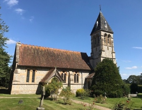
| Description | : | The medieval church of St. Laurence, next to West Woodhay House, was destroyed in 1716. A new building in classical style was erected in 1717. None of the memorials from the old church survived. This 1717 building was, in turn, pulled down in 1882 and a new church built on a different site. A fine example of Blomfield's Early English Revival style, it is built of local flint and bath stone. The sanctuary windows are by William Morris's company and the central crucifixion the work of Edward Burne-Jones. The nave windows illustrate the 'Te Deum'. The carvings over the altar are... Read More |
frequently asked questions (FAQ):
-
Where is West Woodhay Churchyard?
West Woodhay Churchyard is located at West Woodhay, West Berkshire Unitary Authority ,Berkshire ,England.
-
West Woodhay Churchyard cemetery's updated grave count on graveviews.com?
0 memorials
-
Where are the coordinates of the West Woodhay Churchyard?
Latitude: 51.3637960
Longitude: -1.4385220
Nearby Cemetories:
1. St. Martin's Churchyard
East Woodhay, Basingstoke and Deane Borough, England
Coordinate: 51.3511800, -1.4188700
2. Saint Swithun Churchyard
Combe, West Berkshire Unitary Authority, England
Coordinate: 51.3445800, -1.4728000
3. St. Michael's Churchyard
Inkpen, West Berkshire Unitary Authority, England
Coordinate: 51.3722999, -1.4877492
4. St. Thomas Churchyard
Woolton Hill, Basingstoke and Deane Borough, England
Coordinate: 51.3517900, -1.3841060
5. St. Mary the Virgin Churchyard
Kintbury, West Berkshire Unitary Authority, England
Coordinate: 51.4007840, -1.4505240
6. St Mary Churchyard
Hamstead Marshall, West Berkshire Unitary Authority, England
Coordinate: 51.3981940, -1.3977010
7. St Barnabas Churchyard
Faccombe, Test Valley Borough, England
Coordinate: 51.3204100, -1.4415400
8. St. James the Great
Buttermere, Wiltshire Unitary Authority, England
Coordinate: 51.3475000, -1.5090000
9. St. Michael and All Angels Churchyard
Enborne, West Berkshire Unitary Authority, England
Coordinate: 51.3893860, -1.3751660
10. St Michael Cemetery
Netherton, Test Valley Borough, England
Coordinate: 51.3175780, -1.4622810
11. St Peter Churchyard
Linkenholt, Test Valley Borough, England
Coordinate: 51.3205900, -1.4798200
12. Highclere Cemetery
Highclere, Basingstoke and Deane Borough, England
Coordinate: 51.3319240, -1.3625700
13. St James Churchyard
Ashmansworth, Basingstoke and Deane Borough, England
Coordinate: 51.3071600, -1.4122600
14. St Mary the Virgin Churchyard
Vernham Dean, Test Valley Borough, England
Coordinate: 51.3105630, -1.4994880
15. St Michael and All Angels Churchyard
Crux Easton, Basingstoke and Deane Borough, England
Coordinate: 51.3037600, -1.3918900
16. St Saviour Churchyard
Hungerford, West Berkshire Unitary Authority, England
Coordinate: 51.4207210, -1.5054790
17. Highclere Stud Equine Cemetery
Burghclere, Basingstoke and Deane Borough, England
Coordinate: 51.3125000, -1.3588400
18. Church of the Ascension Churchyard
Burghclere, Basingstoke and Deane Borough, England
Coordinate: 51.3466000, -1.3269200
19. St. Mary the Virgin Churchyard
Speen, West Berkshire Unitary Authority, England
Coordinate: 51.4076540, -1.3469800
20. Saint Lawrence Churchyard
Hungerford, West Berkshire Unitary Authority, England
Coordinate: 51.4164100, -1.5208820
21. St Mary and St John the Baptist Churchyard
Newtown, Basingstoke and Deane Borough, England
Coordinate: 51.3702000, -1.3169200
22. Newtown Road Cemetery
Newbury, West Berkshire Unitary Authority, England
Coordinate: 51.3924300, -1.3252900
23. Beacon Hill
Highclere, Basingstoke and Deane Borough, England
Coordinate: 51.3126090, -1.3467130
24. St Nicolas Churchyard
Newbury, West Berkshire Unitary Authority, England
Coordinate: 51.4009920, -1.3248370