
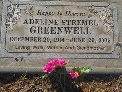

Adeline Stremel Greenwell
| Birth | : | 20 Dec 1914 Loretta, Rush County, Kansas, USA |
| Death | : | 29 Jun 2005 Sun City, Maricopa County, Arizona, USA |
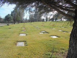
| Burial | : | New Auburn Cemetery, Auburn, Placer County, USA |
| Coordinate | : | 38.9026900, -121.0870800 |
| Plot | : | N/C-10-23-5 |
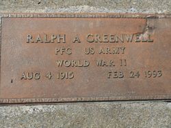
| Inscription | : | In loving memory of Mom & Dad |
| Description | : | A funeral Mass for Adeline S. Greenwell of Sun City, Ariz., was conducted Saturday at Saint Elizabeth Seton's in Sun City. Visitation for family and friends will be from 10 to 11 a.m. Friday at Chapel of the Hills in Auburn. Family services will be conducted at 11 a.m.. Friday at Chapel of the Hills in Auburn. Following the services, she will be buried next to her husband, Ralph A. Greenwell, in the Auburn Cemetery. Mrs. Greenwell died Wednesday, June 29, in Sun City. She was 90. She was born Dec. 20, 1914, in Loretta, Kan., to Leo... Read More |
frequently asked questions (FAQ):
-
Where is Adeline Stremel Greenwell's memorial?
Adeline Stremel Greenwell's memorial is located at: New Auburn Cemetery, Auburn, Placer County, USA.
-
When did Adeline Stremel Greenwell death?
Adeline Stremel Greenwell death on 29 Jun 2005 in Sun City, Maricopa County, Arizona, USA
-
Where are the coordinates of the Adeline Stremel Greenwell's memorial?
Latitude: 38.9026900
Longitude: -121.0870800
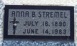
Family Members:
Parent
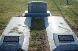
Spouse
Siblings


Nearby Cemetories:
1. New Auburn Cemetery
Auburn, Placer County, USA
Coordinate: 38.9026900, -121.0870800
2. Old Auburn Cemetery
Auburn, Placer County, USA
Coordinate: 38.9023720, -121.0812230
3. Clark Ashton Smith Gravesite
Auburn, Placer County, USA
Coordinate: 38.8952100, -121.0770500
4. Placer County Hospital Cemetery
Auburn, Placer County, USA
Coordinate: 38.9045120, -121.0721320
5. Bethlehem Lutheran Church Columbarium
Auburn, Placer County, USA
Coordinate: 38.8932350, -121.0749690
6. First Congregational Church Memorial Garden
Auburn, Placer County, USA
Coordinate: 38.9118660, -121.0711770
7. Chinese Cemetery
Auburn, Placer County, USA
Coordinate: 38.9183502, -121.0802383
8. Maidu Indian Burial Grounds
Auburn, Placer County, USA
Coordinate: 38.8744350, -121.0777290
9. Ophir Cemetery
Placer County, USA
Coordinate: 38.8928870, -121.1273790
10. Newcastle Cemetery
Newcastle, Placer County, USA
Coordinate: 38.8708880, -121.1444060
11. Wells Cemetery
Auburn, Placer County, USA
Coordinate: 38.9667000, -121.1054900
12. Gold Hill Cemetery
Gold Hill, Placer County, USA
Coordinate: 38.9025000, -121.1802200
13. Stewarts Flat Cemetery
Penryn, Placer County, USA
Coordinate: 38.8447360, -121.1507950
14. Bayley Family Cemetery
Pilot Hill, El Dorado County, USA
Coordinate: 38.8438800, -121.0148900
15. Lone Star Cemetery
Placer County, USA
Coordinate: 38.9757996, -121.1380997
16. Rattlesnake Bar Graveyard
Auburn, Placer County, USA
Coordinate: 38.8163050, -121.0895100
17. Clipper Gap Cemetery
Clipper Gap, Placer County, USA
Coordinate: 38.9784880, -121.0256590
18. Mansur Family Cemetery
Loomis, Placer County, USA
Coordinate: 38.8139600, -121.1214000
19. Pilot Hill Cemetery
Pilot Hill, El Dorado County, USA
Coordinate: 38.8301010, -121.0093307
20. Prosser Family Cemetery
Loomis, Placer County, USA
Coordinate: 38.8071900, -121.1285600
21. Esoteric Fraternity Cemetery
Applegate, Placer County, USA
Coordinate: 38.9946190, -120.9687490
22. Georgetown-Renke Cemetery Annex
Georgetown, El Dorado County, USA
Coordinate: 38.8964610, -120.9116240
23. Greenwood Pioneer Cemetery
Greenwood, El Dorado County, USA
Coordinate: 38.8985786, -120.9099274
24. Spanish Dry Diggings Cemetery
Greenwood, El Dorado County, USA
Coordinate: 38.9431600, -120.9158000