
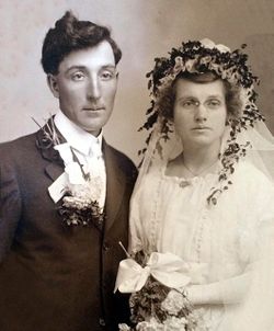
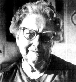
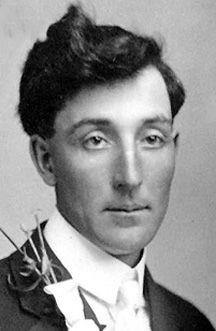
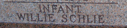
Alma Anna Sophia Schlie Koenig
| Birth | : | 14 Nov 1894 |
| Death | : | 1 Feb 1990 |
| Burial | : | Saint Anne's Church, Woodplumpton, City of Preston, England |
| Coordinate | : | 53.8038130, -2.7621940 |
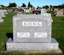
| Inscription | : | KOENIG Fred H. 1886 - 1968 Alma A. 1895 - 1990 |
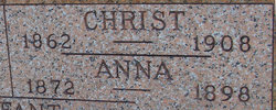
| Description | : | Alma Anna Sophia Frieda Schlie Koenig b. November 14, 1894 in rural Grand Meadow Township, Clayton County, Iowa d. February 01, 1990 in the Postville Community Memorial Hospital in Postville, Allamakee, Iowa married Fred Henry Koenig January 24, 1917 in the Saint Paul Lutheran Parsonage in Postville, Allamakee County, Iowa Father: Christian John Schlie b. about 1871 in Passon, Ostpreussen d. 3 Dec 1908 in Forest City Township, Howard, Iowa Mother: Anna Louisa Mohs b. 25 Nov 1872 in Mecklenburg-Schwerin, Germany d. 22 Jul 1898 in Iowa Obituary from the "Postville Herald": Funeral services for Alma Koenig were held Saturday, Feb. 3,... Read More |
frequently asked questions (FAQ):
-
Where is Alma Anna Sophia Schlie Koenig's memorial?
Alma Anna Sophia Schlie Koenig's memorial is located at: Saint Anne's Church, Woodplumpton, City of Preston, England.
-
When did Alma Anna Sophia Schlie Koenig death?
Alma Anna Sophia Schlie Koenig death on 1 Feb 1990 in
-
Where are the coordinates of the Alma Anna Sophia Schlie Koenig's memorial?
Latitude: 53.8038130
Longitude: -2.7621940
Family Members:
Parent

Spouse
Siblings

Children
Flowers:


Nearby Cemetories:
1. Saint Anne's Church
Woodplumpton, City of Preston, England
Coordinate: 53.8038130, -2.7621940
2. St Andrew George Haydock Roman Catholic Churchyard
Cottam, City of Preston, England
Coordinate: 53.7879280, -2.7591570
3. St Mary's Newhouse
Barton, City of Preston, England
Coordinate: 53.8205240, -2.7406500
4. St. John Baptist Churchyard
Broughton-in-Amounderness, City of Preston, England
Coordinate: 53.8033700, -2.7170400
5. St. Lawrence Churchyard
Barton, City of Preston, England
Coordinate: 53.8289213, -2.7366654
6. St. Mary's Churchyard
Lea, City of Preston, England
Coordinate: 53.7733810, -2.7942770
7. St. Andrew's Churchyard
Ashton-on-Ribble, City of Preston, England
Coordinate: 53.7687030, -2.7359180
8. St. John the Evangelist Churchyard
Clifton, Fylde Borough, England
Coordinate: 53.7758600, -2.8158500
9. Christ Church Churchyard
Fulwood, City of Preston, England
Coordinate: 53.7771920, -2.7028700
10. St. Peters Churchyard
Inskip with Sowerby, Wyre Borough, England
Coordinate: 53.8347100, -2.8175200
11. Christ Churchyard
Treales, Fylde Borough, England
Coordinate: 53.8045970, -2.8440710
12. St Walburge's RC Church
Preston, City of Preston, England
Coordinate: 53.7629690, -2.7149620
13. St. Mary's Churchyard
Preston, City of Preston, England
Coordinate: 53.8010830, -2.6779600
14. St. Hilda's Churchyard
Bilsborrow, Wyre Borough, England
Coordinate: 53.8522170, -2.7420090
15. Inskip Baptist Churchyard
Inskip with Sowerby, Wyre Borough, England
Coordinate: 53.8353150, -2.8299610
16. Saint Peter Churchyard
Preston, City of Preston, England
Coordinate: 53.7634100, -2.7080700
17. St Mary Churchyard
Penwortham, South Ribble Borough, England
Coordinate: 53.7551800, -2.7234210
18. Grey Friars' Church
Preston, City of Preston, England
Coordinate: 53.7601480, -2.7084600
19. Holy Trinity
Preston, City of Preston, England
Coordinate: 53.7613030, -2.7030580
20. Friends Meeting House Burial Ground (Defunct)
Preston, City of Preston, England
Coordinate: 53.7610250, -2.7030380
21. Christ Church Churchyard
Preston, City of Preston, England
Coordinate: 53.7573210, -2.7103080
22. St. Ignatius RC Churchyard
Preston, City of Preston, England
Coordinate: 53.7635270, -2.6965870
23. St. George the Martyr
Preston, City of Preston, England
Coordinate: 53.7591220, -2.7025660
24. St. Wilfrid's Catholic Cemetery
Preston, City of Preston, England
Coordinate: 53.7581670, -2.7044930