
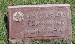
| Birth | : | 9 Jan 1852 Indiana, USA |
| Death | : | 10 Nov 1941 Indiana, USA |
| Burial | : | Cottage Hill Cemetery, Brazil, Clay County, USA |
| Coordinate | : | 39.5186005, -87.1517029 |
frequently asked questions (FAQ):
-
Where is Alonzo Wilfred O'Brien's memorial?
Alonzo Wilfred O'Brien's memorial is located at: Cottage Hill Cemetery, Brazil, Clay County, USA.
-
When did Alonzo Wilfred O'Brien death?
Alonzo Wilfred O'Brien death on 10 Nov 1941 in Indiana, USA
-
Where are the coordinates of the Alonzo Wilfred O'Brien's memorial?
Latitude: 39.5186005
Longitude: -87.1517029
Family Members:
Parent

Spouse
Siblings
Children
Flowers:


Nearby Cemetories:
1. Old Hill Cemetery
Brazil, Clay County, USA
Coordinate: 39.5198300, -87.1432100
2. Clearview Cemetery
Posey Township, Clay County, USA
Coordinate: 39.5141983, -87.1733017
3. Summit Lawn Cemetery
Brazil, Clay County, USA
Coordinate: 39.4998190, -87.1445310
4. Bee Ridge Cemetery
Brazil, Clay County, USA
Coordinate: 39.5367584, -87.1687469
5. Wools Cemetery
Staunton, Clay County, USA
Coordinate: 39.4895690, -87.1446970
6. Stunkard Cemetery
Brazil, Clay County, USA
Coordinate: 39.5463982, -87.1346970
7. Brazil Cemetery
Brazil, Clay County, USA
Coordinate: 39.5352500, -87.1149000
8. Restlawn Cemetery
Brazil, Clay County, USA
Coordinate: 39.5353000, -87.1142000
9. Reffet Cemetery
Brazil, Clay County, USA
Coordinate: 39.4891960, -87.1260020
10. Otter Creek Cemetery
Cardonia, Clay County, USA
Coordinate: 39.5473500, -87.1224000
11. Billtown Cemetery
Billtown, Clay County, USA
Coordinate: 39.5083008, -87.1996994
12. Vest Cemetery
Staunton, Clay County, USA
Coordinate: 39.4795685, -87.1728516
13. Poplar Cemetery
Knightsville, Clay County, USA
Coordinate: 39.5042000, -87.0980988
14. Staunton German Lutheran Cemetery
Staunton, Clay County, USA
Coordinate: 39.4806510, -87.1839270
15. Harpold Cemetery
Ehrmandale, Vigo County, USA
Coordinate: 39.5205994, -87.2144012
16. Saint John's Evangelical Lutheran Cemetery
Center Point, Clay County, USA
Coordinate: 39.4683609, -87.1544952
17. German Cemetery
Clay County, USA
Coordinate: 39.4681015, -87.1547012
18. Bemis Cemetery
Ehrmandale, Vigo County, USA
Coordinate: 39.5483550, -87.2061220
19. Sampson Cemetery
Clay County, USA
Coordinate: 39.5750008, -87.1643982
20. Harmony Cemetery
Harmony, Clay County, USA
Coordinate: 39.5310740, -87.0762920
21. Moreland Cemetery
Ehrmandale, Vigo County, USA
Coordinate: 39.5443600, -87.2239600
22. Union Cemetery
Hoosierville, Clay County, USA
Coordinate: 39.4746390, -87.0958110
23. Webster Cemetery
Brazil, Clay County, USA
Coordinate: 39.5771930, -87.1772110
24. Carter Cemetery
Clay County, USA
Coordinate: 39.5703011, -87.1964035