

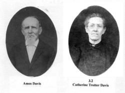
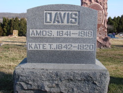
Amos Davis
| Birth | : | 22 Jan 1841 |
| Death | : | 28 May 1919 Indiana, USA |
| Burial | : | Gilroes Cemetery and Crematorium, Leicester, Leicester Unitary Authority, England |
| Coordinate | : | 52.6514359, -1.1721700 |
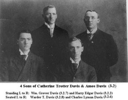
| Description | : | On April 15, 1868 at Hardinsburg he married Catherine (Kate) Trotter who was the second child of William B. Trotter (3.0) and Dorcas Marshall Trotter. Amos was the son of James A. and Mary Roland Davis of Floyd County, Indiana. After their marriage they became residents of Hardinsburg, where Mr. Davis owned an interest in a mill. After 18 months they moved to a farm in Posey Township, where they remained until 1875. They then moved to a home in Madison Township. Amos Davis was trustee of Madison Twp. from 1907 to 1911. |
frequently asked questions (FAQ):
-
Where is Amos Davis's memorial?
Amos Davis's memorial is located at: Gilroes Cemetery and Crematorium, Leicester, Leicester Unitary Authority, England.
-
When did Amos Davis death?
Amos Davis death on 28 May 1919 in Indiana, USA
-
Where are the coordinates of the Amos Davis's memorial?
Latitude: 52.6514359
Longitude: -1.1721700
Family Members:
Parent
Spouse
Siblings
Children


Flowers:


Nearby Cemetories:
1. Gilroes Cemetery and Crematorium
Leicester, Leicester Unitary Authority, England
Coordinate: 52.6514359, -1.1721700
2. St Peter's Church
Glenfield, Blaby District, England
Coordinate: 52.6490490, -1.2063180
3. Leicester Abbey
Leicester, Leicester Unitary Authority, England
Coordinate: 52.6489600, -1.1369470
4. Anstey Cemetery
Anstey, Charnwood Borough, England
Coordinate: 52.6680480, -1.1955570
5. St Mary's Church
Anstey, Charnwood Borough, England
Coordinate: 52.6720090, -1.1888250
6. All Saints Church
Leicester, Leicester Unitary Authority, England
Coordinate: 52.6381940, -1.1403170
7. St Margaret Churchyard
Leicester, Leicester Unitary Authority, England
Coordinate: 52.6403430, -1.1363440
8. St. Nicholas Church
Leicester, Leicester Unitary Authority, England
Coordinate: 52.6351400, -1.1408940
9. Great Meeting Unitarian Chapel
Leicester, Leicester Unitary Authority, England
Coordinate: 52.6379400, -1.1360390
10. Leicester Cathedral
Leicester, Leicester Unitary Authority, England
Coordinate: 52.6347430, -1.1370210
11. St. Mary de Castro Churchyard
Leicester, Leicester Unitary Authority, England
Coordinate: 52.6322610, -1.1404000
12. Church of the Annunciation of St. Mary
Leicester, Leicester Unitary Authority, England
Coordinate: 52.6308229, -1.1417201
13. Belgrave Cemetery
Belgrave, Leicester Unitary Authority, England
Coordinate: 52.6653570, -1.1311220
14. St. Peter's Churchyard
Belgrave, Leicester Unitary Authority, England
Coordinate: 52.6594208, -1.1255690
15. St Peter's Churchyard
Braunstone, Blaby District, England
Coordinate: 52.6208940, -1.1812900
16. St George's Church
Leicester, Leicester Unitary Authority, England
Coordinate: 52.6344300, -1.1267420
17. St. Philip and St. James Churchyard
Groby, Hinckley and Bosworth Borough, England
Coordinate: 52.6639220, -1.2278540
18. Greengate Lane Cemetery
Birstall, Charnwood Borough, England
Coordinate: 52.6800110, -1.1346940
19. Groby Village Cemetery
Groby, Hinckley and Bosworth Borough, England
Coordinate: 52.6542170, -1.2348310
20. St Bartholomew Churchyard
Kirby Muxloe, Blaby District, England
Coordinate: 52.6371750, -1.2320940
21. St James the Great Churchyard
Birstall, Charnwood Borough, England
Coordinate: 52.6741150, -1.1189210
22. All Saints Churchyard
Thurcaston, Charnwood Borough, England
Coordinate: 52.6906870, -1.1647320
23. Kirby Muxloe Cemetery
Kirby Muxloe, Blaby District, England
Coordinate: 52.6373740, -1.2337780
24. St Peter's Church (Defunct)
Leicester, Leicester Unitary Authority, England
Coordinate: 52.6300260, -1.1164980