
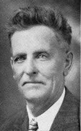
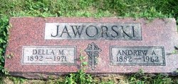
Andrew Anthony Jaworski Sr.
| Birth | : | 22 Oct 1882 Tarnov, Platte County, Nebraska, USA |
| Death | : | 6 Jul 1962 Columbus, Platte County, Nebraska, USA |
| Burial | : | Breachwood Green Baptist Church, Kings Walden, North Hertfordshire District, England |
| Coordinate | : | 51.8843200, -0.3293700 |
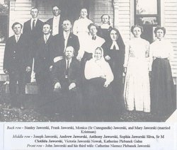
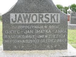
| Description | : | Son of John & Anna (Savage) Jaworski. Married to Della M. Augustyn on 11-15-1910 at St. Josaphat's Catholic Church at Loup City, NE. Occupation: Farmer near Tarnov, NE. He also served as Tarnov Village Clerk 1911-18/Assessor1912-14/Secretary Treasurer of the Tarnov Farmers Elevator 1916-46/recording secretary of the Polish Roman Catholic Union of America 1913-42. -------------------------- http://www.rootsweb.ancestry.com/~neplatte/vitals/vitals1962.html The Daily Telegram, July 7, 1962 JAWORSKI--Andrew Jaworski dies, funeral services Monday Andrew Jaworski, 79, lifetime resident of the Tarnov community, died Friday afternoon in St. Mary's hospital. He had been ill for several years. Funeral services will be at 10 a.m.... Read More |
frequently asked questions (FAQ):
-
Where is Andrew Anthony Jaworski Sr.'s memorial?
Andrew Anthony Jaworski Sr.'s memorial is located at: Breachwood Green Baptist Church, Kings Walden, North Hertfordshire District, England.
-
When did Andrew Anthony Jaworski Sr. death?
Andrew Anthony Jaworski Sr. death on 6 Jul 1962 in Columbus, Platte County, Nebraska, USA
-
Where are the coordinates of the Andrew Anthony Jaworski Sr.'s memorial?
Latitude: 51.8843200
Longitude: -0.3293700
Family Members:
Parent
Spouse

Siblings
Children

Flowers:


Nearby Cemetories:
1. Breachwood Green Baptist Church
Kings Walden, North Hertfordshire District, England
Coordinate: 51.8843200, -0.3293700
2. St Martins
Preston, North Hertfordshire District, England
Coordinate: 51.9091932, -0.2876494
3. All Saints Churchyard
St Pauls Walden, North Hertfordshire District, England
Coordinate: 51.8865400, -0.2689200
4. Ss Peter and Paul Churchyard
Kimpton, North Hertfordshire District, England
Coordinate: 51.8527990, -0.2918240
5. Luton Vauxhall Motors War Memorial
Luton, Luton Borough, England
Coordinate: 51.8745100, -0.3967500
6. St Mary Magdalene Churchyard
Offley, North Hertfordshire District, England
Coordinate: 51.9277300, -0.3357400
7. Vale Cemetery and Crematorium
Luton, Luton Borough, England
Coordinate: 51.9070900, -0.3924930
8. Quaker Burial Ground
Luton, Luton Borough, England
Coordinate: 51.8791910, -0.4023320
9. Church Burial Ground
Luton, Luton Borough, England
Coordinate: 51.8794640, -0.4027310
10. Holy Trinity Churchyard
East Hyde, Central Bedfordshire Unitary Authority, England
Coordinate: 51.8433710, -0.3640760
11. Minsden Chapel
Hitchin, North Hertfordshire District, England
Coordinate: 51.9069200, -0.2595700
12. St. Mary's Churchyard
Luton, Luton Borough, England
Coordinate: 51.8788681, -0.4100020
13. Friend's Burial Ground
Luton, Luton Borough, England
Coordinate: 51.8738060, -0.4170870
14. National Children's Home Cemetery
Harpenden, St Albans District, England
Coordinate: 51.8305000, -0.3563000
15. St Lawrence Churchyard
Ayot St Lawrence, Welwyn Hatfield District, England
Coordinate: 51.8379490, -0.2717340
16. Luton General Cemetery
Luton, Luton Borough, England
Coordinate: 51.8773780, -0.4242060
17. Westfield Road Cemetery
Harpenden, St Albans District, England
Coordinate: 51.8270720, -0.3540300
18. Ayot St Lawrence Old Churchyard
Ayot St Lawrence, Welwyn Hatfield District, England
Coordinate: 51.8377038, -0.2678795
19. St Ippolyts Church
St Ippolyts, North Hertfordshire District, England
Coordinate: 51.9298460, -0.2591680
20. St Andrew Woodside Churchyard
Slip End, Central Bedfordshire Unitary Authority, England
Coordinate: 51.8577160, -0.4306600
21. Hitchin Cemetery
Hitchin, North Hertfordshire District, England
Coordinate: 51.9429090, -0.2732690
22. Holy Trinity Churchyard
Biscot, Luton Borough, England
Coordinate: 51.9028700, -0.4375560
23. St Nicholas Churchyard
Harpenden, St Albans District, England
Coordinate: 51.8169470, -0.3583300
24. St. Mary's Churchyard
Knebworth, North Hertfordshire District, England
Coordinate: 51.8723580, -0.2160890