


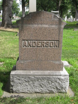
Anna Fredrika Gamberg Anderson
| Birth | : | 9 Sep 1863 Krakemala, Oskarshamns kommun, Kalmar län, Sweden |
| Death | : | 15 Dec 1916 Walla Walla, Walla Walla County, Washington, USA |
| Burial | : | St Dubricius Churchyard, Porlock, West Somerset District, England |
| Coordinate | : | 51.2083000, -3.5955000 |
| Plot | : | MV-51-15-15 |
| Description | : | Anna is the daughter of Gustof Nilson Gamberg and Anna Lisa Danielsdotter. She is a sister to Emma Charlotta, Thilda Sofia, and Johanna Olivia Gamberg. Anna immigrated in 1884. She and Jon Peter (JP) were married in Chicago, IL on 18 September 1889. They moved to Clyde, Walla Walla, Washington where they homesteaded. She had asthma and was terribly bothered by the dust. They moved to the Bryant Street place in Walla Walla in 1898 (Linda Jacky). |
frequently asked questions (FAQ):
-
Where is Anna Fredrika Gamberg Anderson's memorial?
Anna Fredrika Gamberg Anderson's memorial is located at: St Dubricius Churchyard, Porlock, West Somerset District, England.
-
When did Anna Fredrika Gamberg Anderson death?
Anna Fredrika Gamberg Anderson death on 15 Dec 1916 in Walla Walla, Walla Walla County, Washington, USA
-
Where are the coordinates of the Anna Fredrika Gamberg Anderson's memorial?
Latitude: 51.2083000
Longitude: -3.5955000
Family Members:
Spouse

Children


Flowers:


Nearby Cemetories:
1. St Dubricius Churchyard
Porlock, West Somerset District, England
Coordinate: 51.2083000, -3.5955000
2. Porlock Cemetery
Porlock, West Somerset District, England
Coordinate: 51.2033790, -3.5954070
3. Luccombe Extension Cemetery
Luccombe, West Somerset District, England
Coordinate: 51.1897360, -3.5609100
4. St. Mary's Churchyard
Luccombe, West Somerset District, England
Coordinate: 51.1895770, -3.5596880
5. Stoke Pero Churchyard
Porlock, West Somerset District, England
Coordinate: 51.1796510, -3.6060674
6. Selworthy Extension Cemeteries
Selworthy, West Somerset District, England
Coordinate: 51.2098330, -3.5481240
7. All Saints Churchyard
Selworthy, West Somerset District, England
Coordinate: 51.2101800, -3.5475440
8. Culbone St. Bueno's Churchyard
Oare, West Somerset District, England
Coordinate: 51.2213640, -3.6594820
9. All Saints Churchyard
Wootton Courtenay, West Somerset District, England
Coordinate: 51.1801840, -3.5203550
10. Minehead Cemetery
Minehead, West Somerset District, England
Coordinate: 51.2050650, -3.4982030
11. St. Michael's Anglican Church Cemetery
Minehead, West Somerset District, England
Coordinate: 51.2110390, -3.4808250
12. St. Petrock's Churchyard
Timberscombe, West Somerset District, England
Coordinate: 51.1680950, -3.4948210
13. St. Mary the Virgin Churchyard
Oare, West Somerset District, England
Coordinate: 51.2124350, -3.7164290
14. St. John the Evangelist Churchyard
Cutcombe, West Somerset District, England
Coordinate: 51.1424576, -3.5295319
15. St. Mary Magdalene Churchyard
Exford, West Somerset District, England
Coordinate: 51.1341450, -3.6342160
16. Grabbist Hill Cemetery
Dunster, West Somerset District, England
Coordinate: 51.1820510, -3.4492540
17. George Street Cemetery
Dunster, West Somerset District, England
Coordinate: 51.1833740, -3.4483046
18. Priory Churchyard of St. George
Dunster, West Somerset District, England
Coordinate: 51.1832000, -3.4459000
19. Saint Andrew's Churchyard
Withypool, West Somerset District, England
Coordinate: 51.1078060, -3.6492700
20. Winsford Churchyard
Winsford, West Somerset District, England
Coordinate: 51.1038000, -3.5665000
21. Blesssed Virgin Mary Churchyard
Luxborough, West Somerset District, England
Coordinate: 51.1321490, -3.4680500
22. Saint John the Baptist Churchyard
Carhampton, West Somerset District, England
Coordinate: 51.1746000, -3.4186000
23. St.Luke's Churchyard
Simonsbath, West Somerset District, England
Coordinate: 51.1408600, -3.7514560
24. St Peter's Church Exton
Exton, West Somerset District, England
Coordinate: 51.0925840, -3.5352300