

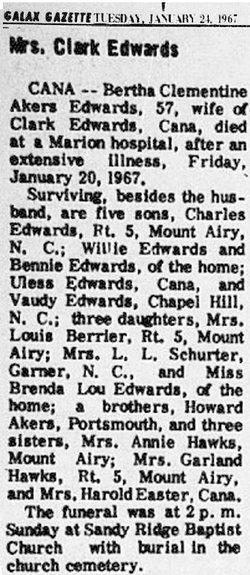
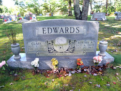
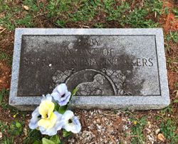
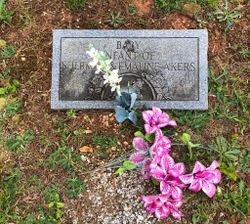
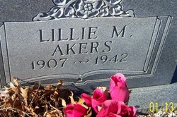
Bertha Clementine Akers Edwards
| Birth | : | 6 Oct 1909 Carroll County, Virginia, USA |
| Death | : | 20 Jan 1967 Marion, Smyth County, Virginia, USA |
| Burial | : | Meadow Branch Cemetery, Bean Station, Grainger County, USA |
| Coordinate | : | 36.3572006, -83.2822037 |
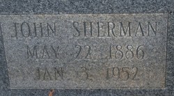
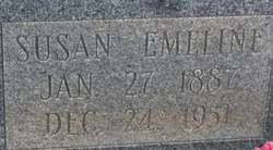
| Description | : | Parents: John Sherman Akers (1886-1952)and Susan Emeline Cagle (1887-1951) |
frequently asked questions (FAQ):
-
Where is Bertha Clementine Akers Edwards's memorial?
Bertha Clementine Akers Edwards's memorial is located at: Meadow Branch Cemetery, Bean Station, Grainger County, USA.
-
When did Bertha Clementine Akers Edwards death?
Bertha Clementine Akers Edwards death on 20 Jan 1967 in Marion, Smyth County, Virginia, USA
-
Where are the coordinates of the Bertha Clementine Akers Edwards's memorial?
Latitude: 36.3572006
Longitude: -83.2822037
Family Members:
Parent
Spouse
Siblings

Children

Flowers:


Nearby Cemetories:
1. Meadow Branch Cemetery
Bean Station, Grainger County, USA
Coordinate: 36.3572006, -83.2822037
2. Holt Cemetery #2
Bean Station, Grainger County, USA
Coordinate: 36.3630560, -83.2844440
3. Moores Chapel Cemetery
Bean Station, Grainger County, USA
Coordinate: 36.3488998, -83.2897034
4. Central United Methodist Church Cemetery
Bean Station, Grainger County, USA
Coordinate: 36.3422740, -83.2798470
5. DeBord Cemetery
Bean Station, Grainger County, USA
Coordinate: 36.3315000, -83.2834000
6. Garrett Cemetery
Grainger County, USA
Coordinate: 36.3414001, -83.3082962
7. Samsel Lakeview Cemetery
Bean Station, Grainger County, USA
Coordinate: 36.3475800, -83.3189468
8. Samsel Cemetery
Bean Station, Grainger County, USA
Coordinate: 36.3424020, -83.3167060
9. County Line Cemetery
Bean Station, Grainger County, USA
Coordinate: 36.3207700, -83.2789850
10. Meek Cemetery
Bean Station, Grainger County, USA
Coordinate: 36.3207180, -83.2797150
11. Dalton Cemetery
Bean Station, Grainger County, USA
Coordinate: 36.3428001, -83.3296967
12. First Independent Freewill Baptist Church Cemetery
Bean Station, Grainger County, USA
Coordinate: 36.3158860, -83.2855850
13. Adriel Baptist Church Cemetery
Bean Station, Grainger County, USA
Coordinate: 36.3125000, -83.2897034
14. Samsel Cemetery
Bean Station, Grainger County, USA
Coordinate: 36.3114014, -83.2925034
15. Bowlin Cemetery
Hancock County, USA
Coordinate: 36.4067001, -83.2581024
16. Bowlin Cemetery
Bray, Hancock County, USA
Coordinate: 36.4141340, -83.2956790
17. Dodson Cemetery
Bean Station, Grainger County, USA
Coordinate: 36.2989006, -83.2869034
18. Rocky Summit Cemetery
Bean Station, Grainger County, USA
Coordinate: 36.2984750, -83.2799030
19. Adams Cemetery
Hancock County, USA
Coordinate: 36.4134570, -83.3106410
20. Grantham Cemetery
Grainger County, USA
Coordinate: 36.2946860, -83.2794570
21. Harville Cemetery
Grainger County, USA
Coordinate: 36.3811802, -83.3543986
22. Harris Cemetery
Grainger County, USA
Coordinate: 36.3055992, -83.3308029
23. Greene Cemetery
Hancock County, USA
Coordinate: 36.4184400, -83.2531400
24. Armstrong Cemetery
Hawkins County, USA
Coordinate: 36.3417015, -83.2031021