
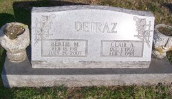
Bertie Mae Walker Detraz
| Birth | : | 18 Feb 1911 |
| Death | : | 26 Jul 2007 |
| Burial | : | Zinnamon Cemetery, West Fork, Washington County, USA |
| Coordinate | : | 35.8230000, -94.2682000 |
| Description | : | ************************************** Madison Courier---July 27, 2007 Madison Courier---July 28, 2007 Bertie Mae Walker Detraz, 96, of Spencer, formerly of Vevay, died Thursday, July 26, 2007, at Owen Valley Health Campus in Spencer. She was born Feb. 18, 1911, in Trimble County, Ky., the daughter of John and Ellen Tingle Walker. She was raised in Trimble County, Ky., later moving to Switzerland County where she lived until 1999 when she moved to Spencer to be near her son. She and her daughter, Frances, sang and played music for revivals, community church services, family gatherings and reunions. She was a member of the Cedar... Read More |
frequently asked questions (FAQ):
-
Where is Bertie Mae Walker Detraz's memorial?
Bertie Mae Walker Detraz's memorial is located at: Zinnamon Cemetery, West Fork, Washington County, USA.
-
When did Bertie Mae Walker Detraz death?
Bertie Mae Walker Detraz death on 26 Jul 2007 in
-
Where are the coordinates of the Bertie Mae Walker Detraz's memorial?
Latitude: 35.8230000
Longitude: -94.2682000
Family Members:
Spouse


Nearby Cemetories:
1. Serenity Place Cemetery
Washington County, USA
Coordinate: 35.8312100, -94.2665000
2. Fall Creek Cemetery
Strickler, Washington County, USA
Coordinate: 35.8344110, -94.3098330
3. English Cemetery
Strickler, Washington County, USA
Coordinate: 35.7970000, -94.3015770
4. Dripping Springs Cemetery
Onda, Washington County, USA
Coordinate: 35.8584310, -94.2932080
5. Liberty 86 Cemetery
Strickler, Washington County, USA
Coordinate: 35.7844009, -94.2910995
6. Old Bethlehem Baptist Church Cemetery
Washington County, USA
Coordinate: 35.8481865, -94.2252731
7. McClelland Cemetery
Washington County, USA
Coordinate: 35.8635950, -94.2410980
8. Baker Cemetery
Onda, Washington County, USA
Coordinate: 35.8680992, -94.2910995
9. McDonald Cemetery
Onda, Washington County, USA
Coordinate: 35.8806000, -94.2799988
10. Morrow Cemetery
Washington County, USA
Coordinate: 35.8492012, -94.3380966
11. Dunkard Cemetery
Strickler, Washington County, USA
Coordinate: 35.7775002, -94.3217010
12. Low Gap Cemetery
West Fork, Washington County, USA
Coordinate: 35.8658218, -94.2063904
13. Brewster Simpson Cemetery
Washington County, USA
Coordinate: 35.8609620, -94.3390260
14. Choate Cemetery
Onda, Washington County, USA
Coordinate: 35.8938200, -94.2732500
15. Bugscuffle Cemetery
Strickler, Washington County, USA
Coordinate: 35.7841500, -94.3419460
16. Burris Cemetery
Washington County, USA
Coordinate: 35.8935000, -94.2482650
17. Scott Cemetery
Prairie Grove, Washington County, USA
Coordinate: 35.8591995, -94.3460999
18. Holcomb Cemetery
West Fork, Washington County, USA
Coordinate: 35.8954065, -94.2519087
19. Parks Cemetery
Hogeye, Washington County, USA
Coordinate: 35.8988991, -94.2906036
20. Clanton Cemetery
Floss, Washington County, USA
Coordinate: 35.7935110, -94.3619370
21. Howell Cemetery
Prairie Grove, Washington County, USA
Coordinate: 35.9056015, -94.2835999
22. Oak Grove Cemetery
Crawford County, USA
Coordinate: 35.7504005, -94.3262787
23. Union Star Cemetery
West Fork, Washington County, USA
Coordinate: 35.8922005, -94.2031021
24. Phillips Cemetery
Hogeye, Washington County, USA
Coordinate: 35.9119760, -94.2556360