
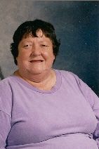
Bonnie Kay Vanmeter Baldwin
| Birth | : | 11 Nov 1943 Petersburg, Grant County, West Virginia, USA |
| Death | : | 6 Jan 2010 Winchester, Frederick County, Virginia, USA |
| Burial | : | Rakaia Cemetery, Rakaia, Ashburton District, New Zealand |
| Coordinate | : | -43.7548910, 171.9939270 |
| Description | : | Bonnie Kay Baldwin, age 66 of Lee St., Moorefield, WV passed away Wednesday evening, January 6, 2010 at the Winchester Medical Center in Winchester, VA. Born November 11, 1943 in Petersburg, WV she was the daughter of the late Garfield L. & Elizabeth (Mongold) Vanmeter. Her husband, James F. Baldwin preceded her in death in March 2008. A sister, Betty Whetzel also preceded her in death. Surviving are two sons: Eddie Baldwin of Moorefield, WV and Robert G. Vanmeter of Keyser, WV; a daughter, Barbara Baldwin of Franklin, WV; six sisters, Karen Whetzel of Moorefield, WV, Sharon Crites of Dorcas,... Read More |
frequently asked questions (FAQ):
-
Where is Bonnie Kay Vanmeter Baldwin's memorial?
Bonnie Kay Vanmeter Baldwin's memorial is located at: Rakaia Cemetery, Rakaia, Ashburton District, New Zealand.
-
When did Bonnie Kay Vanmeter Baldwin death?
Bonnie Kay Vanmeter Baldwin death on 6 Jan 2010 in Winchester, Frederick County, Virginia, USA
-
Where are the coordinates of the Bonnie Kay Vanmeter Baldwin's memorial?
Latitude: -43.7548910
Longitude: 171.9939270
Family Members:
Spouse
Flowers:


Nearby Cemetories:
1. Chertsey Cemetery
Chertsey, Ashburton District, New Zealand
Coordinate: -43.8030500, 171.9319400
2. Barrhill Cemetery
Barrhill, Ashburton District, New Zealand
Coordinate: -43.6756950, 171.8480790
3. Dunsandel Cemetery
Dunsandel, Selwyn District, New Zealand
Coordinate: -43.6710940, 172.1382620
4. Dorie Cemetery
Dorie, Ashburton District, New Zealand
Coordinate: -43.8772900, 172.0862500
5. Killinchy Cemetery
Leeston, Selwyn District, New Zealand
Coordinate: -43.7325610, 172.2411540
6. Kyle Cemetery
Dorie, Ashburton District, New Zealand
Coordinate: -43.9193236, 172.0979192
7. Bishops Corner Cemetery
Southbridge, Selwyn District, New Zealand
Coordinate: -43.7824100, 172.2422900
8. St James Churchyard
Southbridge, Selwyn District, New Zealand
Coordinate: -43.8092360, 172.2502680
9. Ellesmere Public Cemetery
Leeston, Selwyn District, New Zealand
Coordinate: -43.7775690, 172.2599220
10. Ellesmere Catholic Cemetery
Leeston, Selwyn District, New Zealand
Coordinate: -43.7845860, 172.2690990
11. Ashburton Public Cemetery
Ashburton, Ashburton District, New Zealand
Coordinate: -43.8903240, 171.7702810
12. Brookside Cemetery
Brookside, Selwyn District, New Zealand
Coordinate: -43.6751800, 172.2683700
13. Greendale Cemetery
Greendale, Selwyn District, New Zealand
Coordinate: -43.5447560, 172.0772460
14. Highbank Cemetery
Highbank, Ashburton District, New Zealand
Coordinate: -43.6228060, 171.7387780
15. St Luke's Anglican Churchyard
Brookside, Selwyn District, New Zealand
Coordinate: -43.6903100, 172.3029000
16. Pioneer Park Memorial
Ashburton, Ashburton District, New Zealand
Coordinate: -43.9106400, 171.7485300
17. Hororata Cemetery
Hororata, Selwyn District, New Zealand
Coordinate: -43.5196600, 171.9461100
18. St Johns Churchyard
Hororata, Selwyn District, New Zealand
Coordinate: -43.5189100, 171.9457550
19. Sedgemere Cemetery
Sedgemere, Selwyn District, New Zealand
Coordinate: -43.8366600, 172.3149500
20. Glenroy War Memorial
Glenroy, Selwyn District, New Zealand
Coordinate: -43.5199750, 171.8345040
21. Methven Cemetery
Methven, Ashburton District, New Zealand
Coordinate: -43.6346810, 171.6563070
22. St Joseph's Catholic Cemetery
Darfield, Selwyn District, New Zealand
Coordinate: -43.4918030, 172.1081060
23. South Malvern Cemetery
Glentunnel, Selwyn District, New Zealand
Coordinate: -43.4807300, 171.9475200
24. Trinity Church Columbarium
Darfield, Selwyn District, New Zealand
Coordinate: -43.4888350, 172.1052750