
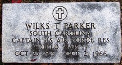
Capt Wilkes Thomas “Skinny” Parker
| Birth | : | 25 Oct 1915 |
| Death | : | 21 Oct 1966 |
| Burial | : | St. Thomas' Churchyard, Simpson, Milton Keynes Borough, England |
| Coordinate | : | 52.0170487, -0.7142377 |
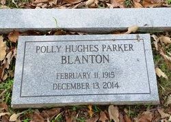
| Description | : | S C Captain U S Air Force WWII HO Polly Hughes Parker Polly married 2nd William Smith Blanton Polly's 2nd marriage furnished by http://www.findagrave.com/cgi-bin/fg.cgi?page=mr&MRid=47078032 |
frequently asked questions (FAQ):
-
Where is Capt Wilkes Thomas “Skinny” Parker's memorial?
Capt Wilkes Thomas “Skinny” Parker's memorial is located at: St. Thomas' Churchyard, Simpson, Milton Keynes Borough, England.
-
When did Capt Wilkes Thomas “Skinny” Parker death?
Capt Wilkes Thomas “Skinny” Parker death on 21 Oct 1966 in
-
Where are the coordinates of the Capt Wilkes Thomas “Skinny” Parker's memorial?
Latitude: 52.0170487
Longitude: -0.7142377
Family Members:
Parent
Spouse
Siblings
Children

Flowers:


Nearby Cemetories:
1. St. Thomas' Churchyard
Simpson, Milton Keynes Borough, England
Coordinate: 52.0170487, -0.7142377
2. St. Michael's Churchyard Open University
Milton Keynes Borough, England
Coordinate: 52.0233487, -0.7118339
3. St Marys Churchyard
Woughton on the Green, Milton Keynes Borough, England
Coordinate: 52.0298869, -0.7234442
4. St. Martin's Churchyard
Fenny Stratford, Milton Keynes Borough, England
Coordinate: 51.9982400, -0.7157800
5. Bletchley Cemetery
Bletchley, Milton Keynes Borough, England
Coordinate: 51.9947900, -0.7189600
6. Holy Trinity Churchyard
Milton Keynes, Milton Keynes Borough, England
Coordinate: 52.0390700, -0.7253500
7. St. Mary's Churchyard
Wavendon, Milton Keynes Borough, England
Coordinate: 52.0257000, -0.6730000
8. All Saints Churchyard
Milton Keynes, Milton Keynes Borough, England
Coordinate: 52.0438000, -0.7070000
9. St. Mary's Churchyard
Bletchley, Milton Keynes Borough, England
Coordinate: 51.9960183, -0.7444740
10. Whalley Drive Cemetery
Bletchley, Milton Keynes Borough, England
Coordinate: 51.9964870, -0.7456010
11. Holy Trinity Churchyard
Woolstone, Milton Keynes Borough, England
Coordinate: 52.0450548, -0.7245233
12. All Saints Churchyard
Bow Brickhill, Milton Keynes Borough, England
Coordinate: 52.0005240, -0.6737110
13. All Saints Churchyard Extension
Bow Brickhill, Milton Keynes Borough, England
Coordinate: 52.0002300, -0.6737940
14. Selbourne Avenue Cemetery
Bletchley, Milton Keynes Borough, England
Coordinate: 51.9880347, -0.7493144
15. St. Lawrence's Churchyard
Broughton, Milton Keynes Borough, England
Coordinate: 52.0522000, -0.6980000
16. St. Mary Magdalene Churchyard
Little Brickhill, Milton Keynes Borough, England
Coordinate: 51.9831000, -0.6763200
17. St. Michael's Churchyard
Woburn Sands, Milton Keynes Borough, England
Coordinate: 52.0087770, -0.6485350
18. Woburn Sands & Aspley Heath War Memorial
Woburn, Central Bedfordshire Unitary Authority, England
Coordinate: 52.0115470, -0.6473350
19. All Saints Churchyard
Loughton, Milton Keynes Borough, England
Coordinate: 52.0326533, -0.7797109
20. St Marys Roman Catholic Cemetery
Woburn Sands, Milton Keynes Borough, England
Coordinate: 52.0103000, -0.6413000
21. Willen Churchyard
Campbell Park, Milton Keynes Borough, England
Coordinate: 52.0624000, -0.7200000
22. St. Mary Churchyard
Milton Keynes Borough, England
Coordinate: 52.0222200, -0.7885200
23. St Mary Churchyard
Great Brickhill, Aylesbury Vale District, England
Coordinate: 51.9682720, -0.6896390
24. Great Brickhill Churchyard Extension
Great Brickhill, Aylesbury Vale District, England
Coordinate: 51.9670890, -0.6898000